
1882 Vincente Ordozgoiti Map Basque Map of San Sebastian, Spain

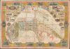

Plano de la Ciudad de San Sebastian.
San Sebastián’s past, present, and imagined future.
- Digital Map Information
- Suitable for large format printing
- Full resolution TIFF file
- ICC color profile embedded
- Delivered instantly via download link
San Sebastián’s past, present, and imagined future.
This is Adolfo Morales de los Ríos's striking 1882 chromolithographic map of San Sebastián, Spain, printed and published by Vicente Ordozgoiti. Combining the vanished fortified town, the expanding modern city, and ambitious proposals for its future, the map captures San Sebastián amid reinvention. Its architect-cartographer helped shape that transformation: Morales de los Ríos (the mapmaker) and Luis Aladrén designed the Gran Casino, whose construction began in the year this plan appeared.A Closer Look
At a scale of 1:2,000, the map combines detailed urban cartography with architectural views and an elaborate advertising border. Color distinguishes existing buildings, proposed construction, public buildings, and structures predating the demolition of the city walls. The result is both a practical city plan and a visual record of San Sebastián's emergence as a fashionable seaside resort.José Manterola offered an unusually detailed contemporary assessment in Euskal-Erria: Revista Bascongada, vol. VII (1882), pp. 122-123. His review conveys both the map's scope and the excitement surrounding the city's transformation. The following is an English translation:
This respected lithographic establishment has just published a handsome map of the capital of Guipúzcoa, remarkable not only for its dimensions - 1.25 × 0.88 meters - but also for its thoughtful conception and careful execution. It is the most complete map published to date and is exceptionally interesting in every respect, embracing, so to speak, the past, present, and future of this beautiful city. Alongside the old quarter, within which the entire town was confined scarcely 20 years ago, and the fortifications and defensive slopes that were the paradise of our childhood and remain among the fondest memories of our youth, it shows the new extension of the city, which has risen as if by magic in an astonishingly short time and already commands the admiration of residents and visitors alike. It also depicts the proposed developments in the Amara district and the land being reclaimed from the sea on both banks of the Urumea, which offer some of the brightest hopes for the future.
Drawn at a scale of 1:2,000, this handsome work extends from the sea washing the slopes below the Castillo de la Mota in the north to the limits of the proposed Urumea promenade and the promenade of the Fountain of Health (Osasun-iturri) in the south; and from the new Gros district - the Salamanca concession - and the Atocha promenade in the east to the bay and promenade of La Concha in the west.
At the Castillo de la Mota, on Mount Urgull, the map depicts not only the fortifications crowning the hill and the picturesque English Cemetery, but also the magnificent proposed promenade encircling it. Plans for this promenade have been studied, and its construction is eagerly awaited by all who take an interest in the future of our cultivated city.
The map indicates existing buildings in blue, proposed buildings or those under construction in pink, public buildings in purple, and, in red, the structures that stood outside the city walls before their demolition in 1863, on land now occupied by the urban extension. Thus, at a glance, one gains a remarkably precise understanding of the city's present extent and all the proposed improvements. The principal public buildings, consulates, inns, and other places of interest are also clearly marked and identified.
Along the Urumea, the map clearly indicates the wall that bounded the river until 1863; the present Zurriola wall; the wall of the Salamanca development, now under construction, together with its extension as far as the approach to the Castillo de la Mota; the old wooden bridge and the modern stone bridge; the river's former course and its future channelization, as it will appear with the proposed layout of the new Urumea promenade; and the various iron bridges proposed to serve the Gros district and the railway station.
Also particularly interesting is the proposed expansion of the Amara district, designed by the municipal architect José Goicoa and shown in its entirety. Finally, the details of the old fortifications and the area outside the walls greatly enhance the map and give it considerable historical value. They recall the magnificent Imperial Tower, which rose majestically opposite the old square; the historic Land Gate; the Breach; the pelota court; the bastions of San Felipe and Santiago; the Amezqueta Tower; the King's Garden (Errege baratza); the splendid hornwork; the meadow and defensive slopes; the Santa Catalina district and promenade; the Triangle; the old Madrid road; the old bullring; and other places - silent witnesses to our childhood, whose memory was gradually fading. The excellent map by Mr. Morales de los Ríos vividly restores their locations and boundaries. It is further embellished with six medallions containing views of the Grand Casino, City Hall, Market, Santa María, San Vicente, and the public buildings of the Plaza de Guipúzcoa, and supplemented by an extensive and varied collection of commercial advertisements.
The map is available for ten reales at the establishment of its publisher, Vicente Ordozgoiti; the Jornet brothers' stationery shop; Rubinat's bookshop; the shop of the widow of Vilinch; and other outlets. Completing it are an intriguing seal depicting San Sebastián's old coat of arms and a general map of the city and its surroundings at a scale of 1:20,000, filling two otherwise vacant spaces in this magnificent work. We warmly recommend it to our readers and congratulate our esteemed friends and contributors, Messrs. Morales de los Ríos and Ordozgoiti, on its execution. -M.
Chromolithography
Chromolithography, sometimes called oleography, is a color lithographic technique developed in the mid-19th century. The process uses multiple lithographic stones, one for each color, to yield a rich composite effect. Generally, a chromolithograph begins with a black basecoat upon which subsequent colors are layered. Some chromolithographs used 30 or more separate lithographic stones to achieve the desired effect. Chromolithograph color can be blended for even more dramatic results. The process became extremely popular in the late 19th and early 20th centuries when it emerged as the dominant method of color printing. The vivid color chromolithography made it exceptionally effective for advertising and propaganda.Publication History and Census
This map was drawn by Spanish architect Adolfo Morales de los Ríos, likely while he was designing and building the Gran Casino de San Sebastián. Litografia Vicente Ordozgoiti printed it in San Sebastián. Each corner bears a secondary name, likely the lithographic artists; these are Francisco Obrero, Marcos Obrero, Antonio Obrero, and Pepín Borero - presumably all from the same family, though we have found no references to them. The OCLC notes a single confirmed example, located at the Biblioteca Nacional de España.Cartographer
Vicente Ordozgoiti (fl. c. 1880 - 1900) was a Spanish lithographer, illustrator, and map publisher based in San Sebastián, in the Basque province of Guipúzcoa. His establishment, Litografía de Vicente Ordozgoiti, operated at 4 Calle Oquendo and advertised artistic, industrial, and commercial lithography. His principal documented cartographic publication is Adolfo Morales de los Ríos's Plano de la Ciudad de San Sebastián (1882), a large color lithographic plan combining detailed urban mapping with architectural views and advertisements for local businesses. Ordozgoiti also collaborated with Morales de los Ríos on architectural publishing: in 1882, his press issued a view of the proposed Gran Casino, drawn by Morales de los Ríos from the design he developed with Luis Aladrén. A contemporary notice described this print as the first in a projected series devoted to the building. Beyond maps and architectural views, Ordozgoiti produced portraits, illustrations, and musical lithography, and contributed to José Manterola's cultural journal Euskal-Erria: Revista Bascongada. A November 1883 legal notice documents his standing in the local printing trade by naming him as the appraiser of lithographic presses, equipment, and drawings on printing stones belonging to another San Sebastián printer. His surviving work connects the city's architectural transformation and commercial growth with the contemporary revival of Basque cultural publishing. His birth and death dates, training, and the founding and closure dates of his establishment remain unconfirmed. Further Details...
Condition
Excellent. Slight wear on old fold lines. Laid on original linen (stable).
References
Manterola, José, 'Noticias bibliográficas y literarias: Plano de la Ciudad de San Sebastián', Euskal-Erria: Revista Bascongada, vol. VII (July–December 1882), pp. 122–123. OCLC 431352245.