1965 Blondel La Rougery Pictorial Scuba Diving Map of the Mediterranean Sea
Mediterranean-blondellarougery-1965$2,900.00


Title
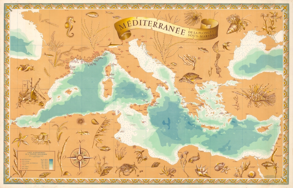
Méditerranée, de la plongée sous-marine; Carte bathymétrique de la plongée sous-marine.
1965 (dated) 27 x 42.5 in (68.58 x 107.95 cm) 1 : 3500000
1965 (dated) 27 x 42.5 in (68.58 x 107.95 cm) 1 : 3500000
Description
A large, scarce 1965 Blondel La Rougery bathymetric pictorial map of the Mediterranean Sea celebrating the nascent scuba craze and detailing regional diving schools and sites.
A Closer Look
Coverage embraces the Mediterranean Basin. Color shading indicates sea depth, while more detailed soundings are provided near coastlines. Diving schools, including those managed by the Club Méditerranée (Club Med) are noted, along with locations of the Confédération Mondiale des Activités Subaquatiques and agents of La Spirotechnique, a division of the firm Air Liquide which sold regulators and other diving equipment, including a revolutionary regulator co-designed by Jacques Cousteau. Finally, the locations of ancient and modern shipwrecks are marked, for any diver curious to explore them. Surrounding the map are illustrations of sea creatures, shipwrecks, and marine flora.Making Diving Accessible
Prior to the Second World War, diving was very difficult and highly dangerous, hardly the stuff for tourists and casual swimmers. But new inventions (such as the Cousteau-Gagnan regulator), businesses, and organizations made the sport much more accessible in the postwar period. Diving took off on both sides of the Atlantic in the 1950s and by the 1960s was an established subculture within the world of maritime sport and recreation.Publication History and Census
This map was drawn and published by the firm Blondel La Rougery in 1965, with assistance from Studio P.I.T. This is the only known example in private hands. We note one institutional holding at the Bibliothèque nationale de France.Cartographer
Blondel la Rougery was a French publishing house founded in Paris around 1902 by the publisher and aerophile Édouard Blondel la Rougery (July 9, 1877 - July 20, 1955). The company specialized in maps and books, particularly those related to aviation and maritime themes. Over time, Blondel la Rougery became well-known for its detailed maps, which were used extensively during both World Wars. In 1934, the firm inherited the aviation and cartographic copyrights of Georges Besançon (1866 - 1934), erstwhile publisher of L'Aérophile. In 1955, his son Max Blondel la Rougery took over the business and continued to manage it until 1976. The company continued to operate until the early 21st century, with its focus remaining largely on map production. The publisher’s works are notable for their precision and artistic quality, making them highly regarded in both historical and cartographic circles. More by this mapmaker...
Condition
Very good. Light foxing in left margin. Other minor imperfections, mostly confined to margins.
References
OCLC 495070583.