This item has been sold, but you can get on the Waitlist to be notified if another example becomes available, or purchase a digital scan.
1974 U.S. Geological Survey Map of the Planet Mercury
MercuryMariner10-usgs-1974$75.00

Title
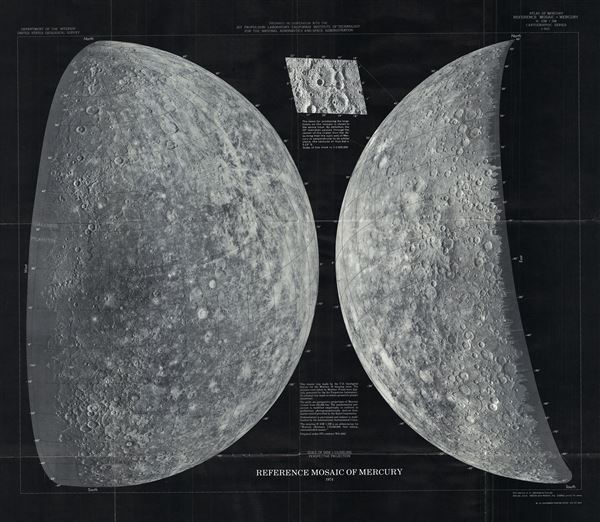
Reference Mosaic of Mercury.
1974 (dated) 23 x 26 in (58.42 x 66.04 cm) 1 : 10000000
1974 (dated) 23 x 26 in (58.42 x 66.04 cm) 1 : 10000000
Description
This is a stunning 1974 mosaic of the planet Mercury by the U. S. Geological Survey for the Mariner 10 imaging team. This map represents the surface of Mercury as photographed by Mariner 10 and digitally processed by NASA's Jet Propulsion Laboratory.
The Mariner 10, launched in November 1973, was on a flyby mission to study the atmosphere, surface and physical characteristics of the planet Mercury. It was also assigned to explore the planet Venus. The Mariner 10 was not only the first spacecraft to visit the planet Mercury, it also was the first to make multiple flybys of any planet (it had three encounters with Mercury as it looped around the Sun). Contact with the Mariner 10 ceased in March 1975, though it is still believed to be orbiting the Sun.
Prepared in cooperation with the Jet Propulsion Laboratory, California Institute of Technology, for the National Aeronautics and Space Administration and published as cartographic series I-903 in the U.S. Geological Survey's Atlas of Mercury.
Cartographer
The Office of the Coast Survey (later the U.S. Geodetic Survey) (1807 - present), founded in 1807 by President Thomas Jefferson and Secretary of Commerce Albert Gallatin, is the oldest scientific organization in the U.S. Federal Government. Jefferson created the "Survey of the Coast," as it was then called, in response to a need for accurate navigational charts of the new nation's coasts and harbors. The first superintendent of the Coast Survey was Swiss immigrant and West Point mathematics professor Ferdinand Hassler. Under the direction of Hassler, from 1816 to 1843, the ideological and scientific foundations for the Coast Survey were established. Hassler, and the Coast Survey under him developed a reputation for uncompromising dedication to the principles of accuracy and excellence. Hassler lead the Coast Survey until his death in 1843, at which time Alexander Dallas Bache, a great-grandson of Benjamin Franklin, took the helm. Under the leadership A. D. Bache, the Coast Survey did most of its most important work. During his Superintendence, from 1843 to 1865, Bache was steadfast advocate of American science and navigation and in fact founded the American Academy of Sciences. Bache was succeeded by Benjamin Pierce who ran the Survey from 1867 to 1874. Pierce was in turn succeeded by Carlile Pollock Patterson who was Superintendent from 1874 to 1881. In 1878, under Patterson's superintendence, the U.S. Coast Survey was reorganized as the U.S. Coast and Geodetic Survey (C & GS or USGS) to accommodate topographic as well as nautical surveys. Today the Coast Survey is part of the National Oceanic and Atmospheric Administration or NOAA. More by this mapmaker...
Source
Atlas of Mercury. Department of the Interior. United States Geological Survey.
Condition
Very good. Original fold lines visible. Blank on verso.