1749 Bellin Map of Nova Zembla and the Entrance to the Kara Sea
MerGlaciale-bellin-1780$250.00

Title
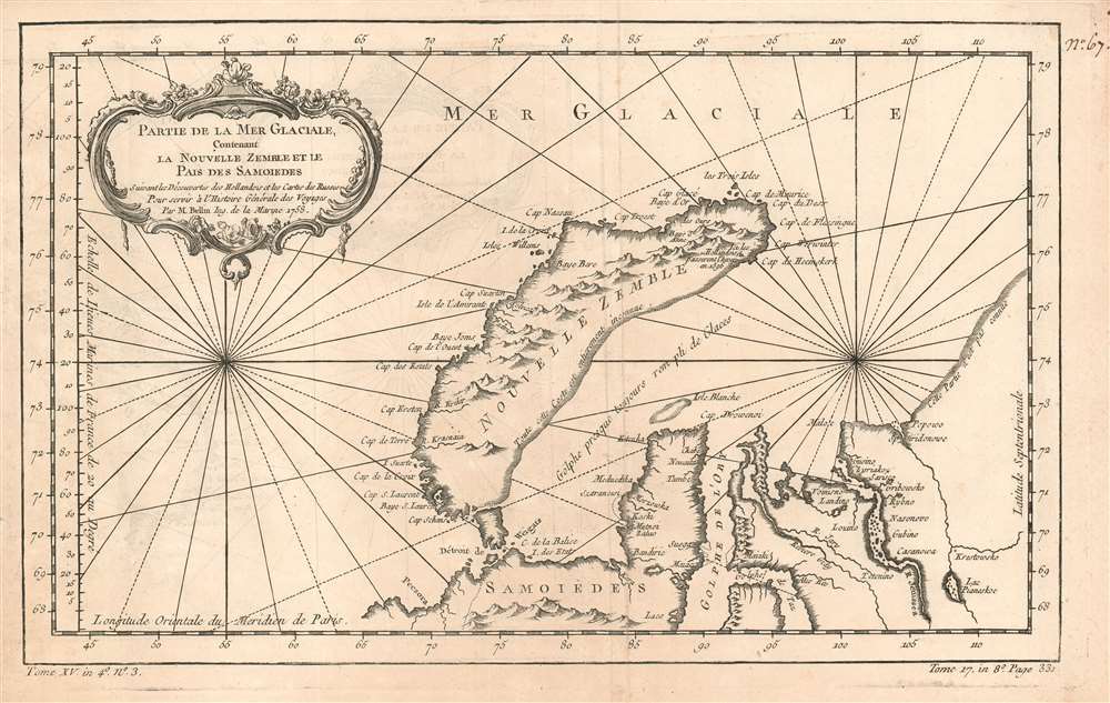
Partie de la Mer Glaciale, Contenant La Nouvelle Zemble et le Pais de Samoiedes suivant les Découvertes des Hollandois et les Cartes des Russes Pour servir à l'Histoire Générale des Voyages Par M. Bellin Ing. de la Marine 1758.
1780 (dated) 8.5 x 13.75 in (21.59 x 34.925 cm) 1 : 6700000
1780 (dated) 8.5 x 13.75 in (21.59 x 34.925 cm) 1 : 6700000
Description
This is a 1758 Bellin map of the northwestern coast of Russia, focusing on the island of Nova Zembla, the mouth of the River Ob, and the limits of European efforts to achieve a northeast passage. The eastern shore of Nova Zembla is sketched in and noted to be entirely unknown; The Kara sea is not named, but it is accurately described as a gulf 'nearly always full of ice.' The site of Barentz's famous refuge in the north of Nova Zembla is marked Ici les Hollandois basserent l'hiver en 1596. The Ob and the Yenisea rivers are shown with reasonable accuracy, but beyond the mouth of the unnamed Pyasina River, the coastline is conjectural and, again, n'est pas connue.
Despite its appearance in Prévost's Histoire générale des voyages - a work perhaps better known for its imaginative flourish than its factuality - Bellin drew on state-of-the-art knowledge for the maps he contributed. Though the map was intended to contextualize Prévost's discussion of Russia's indigenous tributaries to the Tsars, Bellin's map presents a reasonably accurate depiction of what western Europeans understood of the geography of this remote region.
Despite its appearance in Prévost's Histoire générale des voyages - a work perhaps better known for its imaginative flourish than its factuality - Bellin drew on state-of-the-art knowledge for the maps he contributed. Though the map was intended to contextualize Prévost's discussion of Russia's indigenous tributaries to the Tsars, Bellin's map presents a reasonably accurate depiction of what western Europeans understood of the geography of this remote region.
Publication History and Census
This map appears on the market from time to time; OCLC lists only three copies of the separate map in institutional collections, but Prévost's Histoire and the Harpe editions of it are well represented.CartographerS
Jacques-Nicolas Bellin (1703 - March 21, 1772) was one of the most important cartographers of the 18th century. With a career spanning some 50 years, Bellin is best understood as geographe de cabinet and transitional mapmaker spanning the gap between 18th and early-19th century cartographic styles. His long career as Hydrographer and Ingénieur Hydrographe at the French Dépôt des cartes et plans de la Marine resulted in hundreds of high quality nautical charts of practically everywhere in the world. A true child of the Enlightenment Era, Bellin's work focuses on function and accuracy tending in the process to be less decorative than the earlier 17th and 18th century cartographic work. Unlike many of his contemporaries, Bellin was always careful to cite his references and his scholarly corpus consists of over 1400 articles on geography prepared for Diderot's Encyclopedie. Bellin, despite his extraordinary success, may not have enjoyed his work, which is described as "long, unpleasant, and hard." In addition to numerous maps and charts published during his lifetime, many of Bellin's maps were updated (or not) and published posthumously. He was succeeded as Ingénieur Hydrographe by his student, also a prolific and influential cartographer, Rigobert Bonne. More by this mapmaker...
Antoine François Prévost d'Exiles (April 1, 1697 – November 25, 1763), usually known the Abbé Prévost, was a French author and novelist. Having had difficulty in his youth determining a preference for life in the military or life among the Jesuits, he eventually wound up with the Benedictines, with whom he took vows. Despite his taking the vows, the vows evidently did not take with him: in 1728 he abandoned his abbey and fled to London. Naturally, he became a writer. In this he was prolific, both producing his own work and translations of others. Beginning in 1726, he published the first volume of his Histoire générale des voyages, which he worked on for the remained of his life and which was completed by his associates after his death, stretching to 25 volumes. Learn More...
Source
De la Harpe, Abrégé de l'histoire générale des voyages. (Paris) 1780.
Condition
Very good condition. Original folds visible, else a bold, sharp example.
References
OCLC 163344405.