This item has been sold, but you can get on the Waitlist to be notified if another example becomes available, or purchase a digital scan.
1713 Delisle Map of the Southern Champagne Region, France
MeridionaleDeChampagne-delisle-1713$200.00

Title
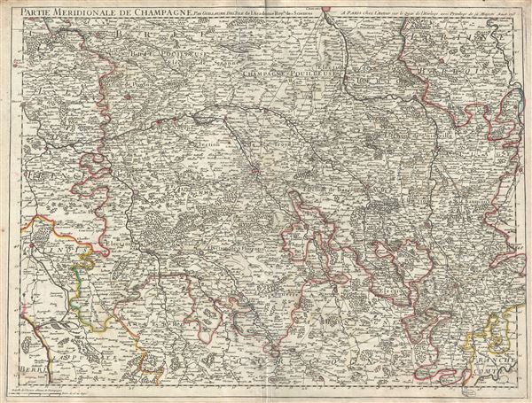
Partie Meridionale de Champagne.
1713 (dated) 19 x 25.5 in (48.26 x 64.77 cm) 1 : 400000
1713 (dated) 19 x 25.5 in (48.26 x 64.77 cm) 1 : 400000
Description
A beautiful 1713 map of the southern part of the Champagne Region in France by Guillaume De L'isle. It covers the Champagne-Ardenne and the Ile-de-France regions in northeast France. The map covers from Nemours east to Vaucouleurs and from Chalons south as far as Gray and includes the whole and parts of the departments of Aube, Yonne, Marne, Haute Marne, Seine-et-Marne and Cote-d'Or. The map renders the entire region in extraordinary detail offering both topographical and political information with mountains and forests beautifully rendered in profile.
The Champagne region is famous around the world for its spectacular sparkling wines of the same name. The map is centered on the department of Aube. The regions of Aube and Yonne (here located in the lower left quadrant of the map) are known for their production of Chaource cheese. Chaource is a cow's milk cheese, cylindrical in shape. The central pate is soft, creamy in color, and slightly crumbly, and is surrounded by a white penicillium candidum rind.
Historically the province of Champagne was bounded on the north by the bishopric of Liege and by Luxembourg, on the east by Lorraine, on the south by Burgundy, and on the west by Ilele-de-France, and by Picardy. Along with the other original French provinces, Champagne was abolished as a separate entity in 1790.
The Haute Marne region, mapped here in the bottom right quadrant, is known for a variety of wines from the Coiffy-le-Haut vineyard, champagne from Rizaucourt-Argentolles, and the local favorite, 'Choue' beer. It is also famous for its production of Langres, a salty cheese with a pronounced odor. In the top left quadrant the region if Brie is noted. Part of the Seine-et-Marne department, this region produces a wide variety of wines and hosts an annual wine and cheese fair. This area is known for its production of a brie-style cheese called 'Fromage de Meaux.' Over 25 liters of milk are used produce just one wheel of this raw-milk cheese. When ripe, its rind breaks at the slightest touch, allowing the beautiful, hay-colored, almost liquid paste to ooze out. The map also includes part of the Cote-d'Or, a premier wine-growing region of France. It produces what are arguably the world's finest, and most expensive Pinot noir and Chardonnay wines.
Overall, a fabulous decorative piece for perfect for wine store, Champagne wine cellars, and French restaurants. This map was created by Guillaume De L'isle in 1713.
Cartographer
The De L'Isle family (fl. c. 1700 - c. 1760) (also written Delisle) were, in composite, a mapmaking tour de force who redefined early 18th century European cartography. Claude De L'Isle (1644 -1720), the family patriarch, was Paris based a historian and geographer under Nicholas Sanson. De L'Isle and his sons were proponents of the school of "positive geography" and were definitive figures, defining the heights of the Golden Age of French Cartography. Of his twelve sons, four, Guillaume (1675 - 1726), Simon Claude (1675 - 1726), Joseph Nicholas (1688 - 1768) and Louis (1720 - 1745), made a significant contributions to cartography. Without a doubt Guillaume was the most remarkable member of the family. It is said that Guillaume's skill as a cartographer was so prodigious that he drew his first map at just nine years of age. He was tutored by J. D. Cassini in astronomy, science, mathematics and cartography. By applying these diverse disciplines to the vast stores of information provided by 18th century navigators, Guillaume created the technique that came to be known as "scientific cartography", essentially an extension of Sanson's "positive geography". This revolutionary approach transformed the field of cartography and created a more accurate picture of the world. Among Guillaume's many firsts are the first naming of Texas, the first correct map of the Mississippi, the final rejection of the insular California fallacy, and the first identification of the correct longitudes of America. Stylistically De L'Isle also initiated important changes to the medium, eschewing the flamboyant Dutch style of the previous century in favor of a highly detailed yet still decorative approach that yielded map both beautiful and informative. Guillaume was elected to the French Academie Royale des Sciences at 27. Later, in 1718, he was also appointed "Premier Geographe du Roi", an office created especially for him. De L'Isle personally financed the publication of most of his maps, hoping to make heavy royalties on their sales. Unfortunately he met an untimely death in 1728, leaving considerable debt and an impoverished child and widow. De L'Isle's publishing firm was taken over by his assistant, Phillipe Buache who became, posthumously, his son in law. The other De L'Isle brothers, Joseph Nicholas and Louis De L'Isle, were employed in the Service of Peter the Great of Russia as astronomers and surveyors. They are responsible for cataloguing and compiling the data obtained from Russian expeditions in the Pacific and along the northwest coast of America, including the seminal explorations of Vitus Bering and Aleksei Chirikov. The De L'Isles, like their rivals the Vaugondys , must be considered speculative geographers. Speculative geography was a genre of mapmaking that evolved in Europe, particularly Paris, in the middle to late 18th century. Cartographers in this genre would fill in unknown areas on their maps with speculations based upon their vast knowledge of cartography, personal geographical theories, and often dubious primary source material gathered by explorers and navigators. This approach, which attempted to use the known to validate the unknown, naturally engendered many rivalries. The era of speculatively cartography effectively ended with the late 18th century explorations of Captain Cook, Jean Francois de Galaup de La Perouse, and George Vancouver. More by this mapmaker...
Condition
Very good. Minor wear along original centerfold. Original platemark visible. Minor creasing, top and bottom margins, near centerfold.