This item has been sold, but you can get on the Waitlist to be notified if another example becomes available, or purchase a digital scan.
1849 Greenleaf Map of Mexico and Republic pre-Compromise Texas
Mexico-greenleaf-1849$200.00

Title
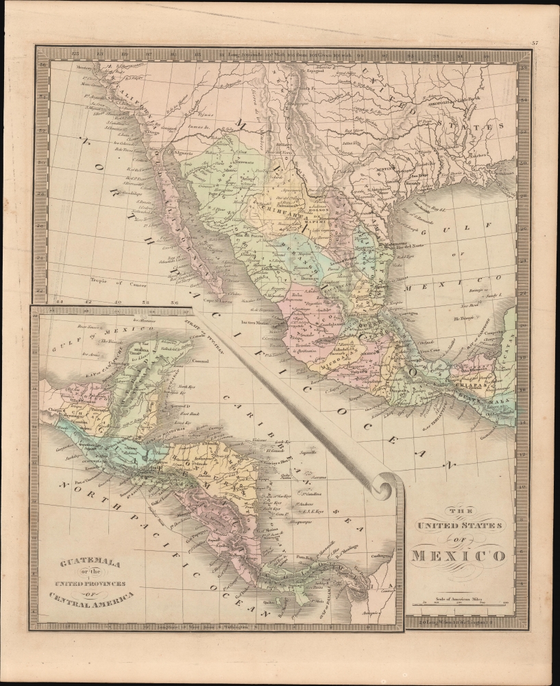
The United States of Mexico. / Guatemala or the United Provinces of Central America.
1849 (undated) 14 x 11 in (35.56 x 27.94 cm) 1 : 12700000
1849 (undated) 14 x 11 in (35.56 x 27.94 cm) 1 : 12700000
Description
This is Jeremiah Greenleaf's 1849 map of Mexico and Central America. The map reflects the original boundaries of the Republic of Texas and the short-lived United Provinces of Central America (Guatemala).
A Closer Look
Essentially two maps on one sheet. The map roughly follows the engraving and scope of the 1832/33 David H. Burr map. Here the color model takes into count the events of the Mexican-American War (1846 - 1848). The boundaries of the Republic of Texas are here identical to those appearing on Burr's map of 1835 (per Rumsey). This reflects a western boundary at the Nueces River and a northern boundary at the Arkansas. Although few changes have been made to the engraving, the color model recognizes the 1848 Treaty of Guadeloupe-Hidalgo.The United Provinces of Central America
This inset is here subtitled 'Guatemala or the United Provinces of Central America'. Another layover from the 1832 Burr, this recognizes the Guatemala led federation that existed from 1823-1841. The name was officially changed to the Federal Republic of Central America in 1824. By 1841, cultural and political differences led to infighting and the dissolution of the Union. As with Texas, the color coding here has been updated to reflect the new political reality, but the engraving, with all of Central America being named 'Guatemala', remains.Publication History and Census
This map is a much-updated revision of the David Hugh Burr map of 1833. The Burr map plates eventually fell into the hands of Jeremiah Greenleaf, who revised them for publication in his own Universal Atlas. The present example is from the 1849 edition of the atlas, the last and final, which nonetheless was extensively revised over the 1848. We note an example in the David Rumsey collection, which has been populated digitally throughout OCLC, making a comprehensive survey of existing physical examples nearly impossible. Nonetheless, the 1849 edition of the atlas is rare, which Rumsey correctly noted that it is not in Karpinski. We do note an example, however, in Phillips.Cartographer
Jeremiah Greenleaf (1791 - 1864) is a little known but highly admired American cartographer of the early 19th century. He published from roughly 1830 to 1850. His most important work is A New Universal Atlas; Comprising of all the Principal Empires, Kingdoms, and States Throughout the World and Forming a distinct Atlas of the United States, published in several editions in the 1840s. Many of his maps are reformatted versions of his contemporary David Burr's much admired cartographic works. Greenleaf's maps are extremely rare and admired for their stunningly vivid pastel color washes. More by this mapmaker...
Source
Greenleaf, J., New Universal Atlas, (Brattleboro, Vermont: Greenleaf) 1849.
Condition
Very good.
References
Rumsey 15176.000.