This item has been sold, but you can get on the Waitlist to be notified if another example becomes available, or purchase a digital scan.
1701 Moll Map of Florida, Mexico and the Gulf Coast
MexicoFloridaNewSpain-moll-1701$200.00

Title
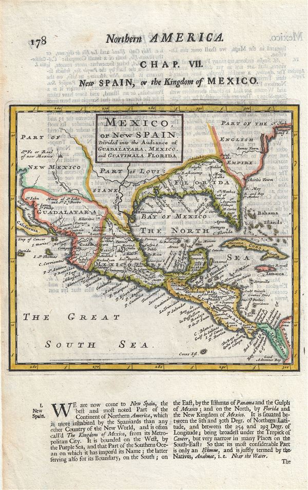
Mexico, or New Spain Divided into the Auddiance of Guadalayara, Mexico, and Guatimala, Florida.
1701 (undated) 9 x 8 in (22.86 x 20.32 cm) 1 : 28500000
1701 (undated) 9 x 8 in (22.86 x 20.32 cm) 1 : 28500000
Description
An uncommon 1701 map by Herman Moll of Mexico, the Gulf Coast, and Florida. Centered on the Gulf Of Mexico (the Bay of Mexico here), this map covers from Baja California to Florida and Cuba, covering in the process, the Gulf of Mexico, parts of New Mexico as far north as New York and Santa Fe, and as far as south as Panama. Based on Moll's maps from the same issue of A System of Geography, the southern part of what appears to be Baja California here is presumably a part of Insular California. The Spainich possession of Florida extends west as far as Louisiana, while Texas is 'Part of Louisiana.' The Ohio River flows west past the Mississippi, into texas.
Perhaps this maps most striking features are the 'Mines of St. John and St. Barbe.' Although called by some the El Dorado of New Spain, these mines are in fact real and were well known in the 17th century. The Mines of St. Barbe are better known as the Santa Barbara silver mines of Chihuahua-Durango. These mines were first discovered in 1567 by the Spanish Conquistador Rodrigo del Rio de Losa. Although initially difficult to exploit due to extreme remoteness and lack of indigenous labor in the region, by 1600 Santa Barbara had grown to a population of 7000 and was well on its way to becoming a wealthy silver town.
Rene Robert Cavalier, Sieur de La Salle, a French nobleman, explored the lower reaches of the Mississippi from the north, reaching the delta in 1682. Recognizing the enormous profit potential in controlling the Mississippi River, thus linking French colonies in Canada with the Gulf of Mexico, La Salle returned to Europe to petition the King to build a settlement at the mouth of the river. Permission granted, he returned to the Gulf Coast to found Fort St. Louis. Unfortunately, La Salle was unable to rediscover the mouth of the Mississippi due to difficulties in measuring longitude as well as the inherently confusing nature of that coastline and instead founded his colony far west of its intended location.
Although it may have been an error that La Salle founded his colony far to the west of the Mississippi at Matagorda Bay, he was certainly aware of the political implication of its perceived proximity to the Santa Barbara Mines. In addition to several eastward expeditions in search of the mouth of the Mississippi, there is strong evidence that La Salle also traveled extensively west of the Mississippi, no doubt in hopes of seizing the Santa Barbara mines. Louis Hennepin, a Franciscan Recollect priest, both a high ranking member of La Salle's expedition and a potent rival to La Salle, claimed that La Salle intended to seize glory in the form of the Santa Barbara mines before he set out on his first expedition. Such was not an impractical ambition. When La Salle sailed from France to found his colony France and Spain were at war. Seizing Santa Barbara would have been a major blow to the Spanish and both a territorial and financial coup for the French. Little did he know that the war with Spain ended just two weeks after he sailed from France and the two nations had become cautious allies.
Curiously, despite Santa Barbara being a prominent and wealthy silver city, and one of the northernmost outposts of New Mexico, back in France La Salle's failure to discover it gave the city an El Dorado mystique. John Law, the Scottish economist, millionaire, con-artist, and murder, wasted no time in capitalizing the Santa Barbara legend to promote his nascent Mississippi Company. He disseminated rumors that the 'mines of St. Barbe' had been discovered and passed out gold ingots supposedly from this mine. Speculation on the mines, as well as other scams, pushed the stock price to astronomical highs, creating one of the world's first bubble economies. This was possible because of cartographers like Moll who made the legend of the Mines de St. Barbe part of early 18th century French popular mythology.
This map was issued as part of the 1701 issue of Herman Moll's System of Geography.
Cartographer
Herman Moll (1654 - 1732) was an important 18th century map publisher and engraver based in London and Holland. Moll's origins are disputed with some suggesting he was born in the Netherlands and others Germany - the Moll name was common in both countries during this period. Most likely Moll was a German from Bremen, as his will, friends, and contemporaries suggest. What is known for certain is that he moved to London in 1678, possibly fleeing the Scanian War, where he worked as an engraver for Moses Pitt and other London map publishers. Around the turn of the century, Moll set up his own shop where he produced a large corpus of work known for its high quality and decorative flair. As a new émigré to England, Moll made himself more English than the English, and through his cartography proved a fierce advocate for his adopted nation. Most of Moll's early maps were issued as loose sheets that would be bound to order, however, he did publish several important atlases late in his career. Moll is said to have made the bold claim that without a doubt "California is an Island" and that he "had in [his] office mariners who have sailed round it." While California may not be an island (yet), it is true that moll had talent for attracting interesting friends and acquaintances. He frequented London's first stock exchange, Jonathan's Coffeehouse at Number 20 Exchange Alley, Cornhill. At the time Jonathan's was known as "a place of very considerable concourse for Merchants, sea faring Men and other traders" (Erleigh, The Viscount, The South Sea Bubble, Manchester: Peter Davies, Ltd., 1933, 21). Eventually this activity attracted the interest of stock brokers, who inspired by sailor's tales, sponsored the ill-fated South Sea Company, the world's first stock bubble. Moll's close circle, mostly from the Coffee House, included scientist Robert Hooke, the writers Daniel Defoe (Robinson Crusoe) and Jonathan Swift (Gulliver's Travels), the pirates William Dampier, William Hacke and Woodes Rogers, and the archeologist William Stukeley. Herman Moll's work was highly regarded for its decorative beauty and was pirated, most notably by the Irish publisher George Grierson, both in his lifetime and after his 1732 death at St. Clement Danes, London. More by this mapmaker...
Source
Moll, H., A System of Geography: Or, A New and Accurate Description of the Earth In all its Empires, Kingdoms and States (London), 1701.
Herman Moll's A System of Geography was first published in 1701. A System of Geography was essentially a larger version of Timothy Childe and Abel Swall's 1695 Thesaurus Geographicus, for which Moll engraved several maps. The enormous success of the Thesaurus Geographicus most likely provided the inspiration for Moll to publish a more complete atlas of his own, which finally resolved into the 1701 issue of A System of Geography. The additional maps included in A System of Geography were stamped 'New' to distinguish them from those rolled over from the Thesaurus. A System of Geography was issued in two parts containing numerous maps as well as extensive descriptive text. It was printed in London by both Timothy Childe and J. Churchill.
Condition
Very good. Original platemark visible. Minor spotting. Text on verso.
References
OCLC: 49398706