1826 Charles Smith Map of Mexico and the West Indies
MexicoWestIndies-smith-1826$500.00

Title
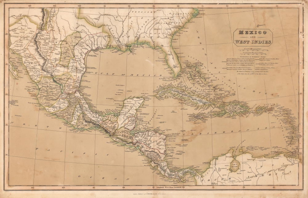
Mexico and the West Indies.
1826 (undated) 15.25 x 23.25 in (38.735 x 59.055 cm) 1 : 8448000
1826 (undated) 15.25 x 23.25 in (38.735 x 59.055 cm) 1 : 8448000
Description
This is a striking old color example of Charles Smith rare 1826 map of Mexico, the West Indies, and Central America.
A Closer Look
Coverage embraces from North Carolina south to northern South America, embracing the entirety of the Gulf of Mexico, Florida, and the West Indies. Islands throughout the West Indies are labeled, including individual islands within the Bahamas and the Virgin Islands. Cities, towns, and villages, along with coastal capes and bays, are labeled in Cuba, Santo Domingo, Puerto Rico (Porto Rico), and many of the Lesser Antilles. In Mexico, cities, towns, and villages appear, and black dots mark significant mines. In Central America, inland detail includes a few cities and towns. Rivers are illustrated throughout, including the Rio Grande del Norte (Rio Grande) in modern-day Texas and the Mississippi. Only rivers and state names (without borders) appear within the U.S. Text below the title and scale notes which islands were the colonial possessions of which European power.Publication History and Census
This map was drawn by J. Smith, engraved by J. Pickett, and published by Charles Smith in 1826. We note four examples cataloged in OCLC: Southern Methodist University, the University of North Texas, the University of Texas at Arlington, and the Daughters of the Republic of Texas Library in San Antonio, Texas.Cartographer
Charles Smith (1768 - 1854) was 19th century British publisher of maps, atlases, and charts, most of which focused on England and London. Smith was appointed map seller to the Prince of Wales in 1809. His early work stylistically resembles the work of Pinkerton, Cary, and Thomson, though on a much smaller scale. From 1826 to 1854 the business traded as Charles Smith and Son. After Charles Smith's death in 1852 the it was taken over by his son William Smith, and later his grandson Guildford Smith (1838 - 1917), who continued to publish maps well into the 20th century. The younger Smith is best known for his introduction of the 'Tape Indicator Map'. This map, which came with a tape measure, enabled users to triangulate their location based coordinates given in an attached guide. The firm was taken over by George Philip in 1916. More by this mapmaker...
Condition
Good. Original outline and wash color. Closed margin tears professionally repaired on verso. Verso repair to centerfold separation. Light wear along original centerfold. Light soiling. Upper margin trimmed to page numbers.
References
OCLC 55496470.