This item has been sold, but you can get on the Waitlist to be notified if another example becomes available, or purchase a digital scan.
1838 Bradford Map of Michigan
Michigan-bradford-1838$225.00

Title
Michigan.
1838 (dated) 15 x 12 in (38.1 x 30.48 cm) 1 : 1600000
1838 (dated) 15 x 12 in (38.1 x 30.48 cm) 1 : 1600000
Description
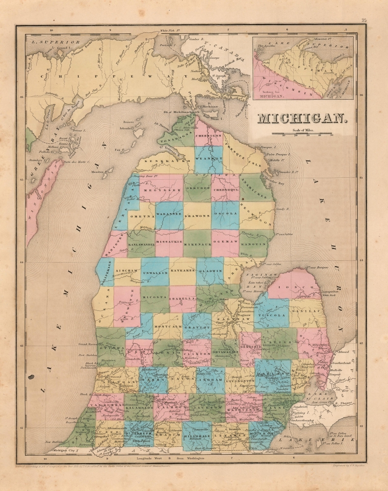
This is an 1841 Thomas G. Bradford map of Michigan. Although just four years after statehood, 1841 Michigan was already a bustling frontier region, with rapid population growth and flourishing agricultural and timber industries.
Each county is illustrated, labeled, and shaded for differentiation. Cities and towns are labeled, including Detroit and Ann Arbor (Ann Arbour). An inset map, entitled 'Northwest Part of Michigan' is situated in the upper right and depicts the western part of the Upper Peninsula and northeastern Wisconsin.
A Closer Look
The map depicts the region from Lake Superior, Green Bay, and Wisconsin to Lake Huron and from Lake Superior to Indiana and Lake Erie. Although still dated 1838, this 1841 state is significantly updated: the Lower Peninsula is entirely divided into counties, whereas in 1838 the northern half of the peninsula was illustrated as being one large county, just as the Upper Peninsula is here. The Central Railroad of Michigan is marked in with a dotted line, only depicting the trackage extending to Allegan. The railroad was initially chartered in 1831 as the Detroit and St. Joseph Railroad, in 1837 renamed the Central Railroad of Michigan, In 1846 it would become the Michigan Central Railroad prior to being absorbed by the New York Central.Each county is illustrated, labeled, and shaded for differentiation. Cities and towns are labeled, including Detroit and Ann Arbor (Ann Arbour). An inset map, entitled 'Northwest Part of Michigan' is situated in the upper right and depicts the western part of the Upper Peninsula and northeastern Wisconsin.
Publication History and Census
This map was engraved by George Boynton; this specific example appeared in the 1841 edition of Bradford and Goodrich's A Universal Illustrated Atlas.CartographerS
Thomas Gamaliel Bradford (1802 - 1887) was born in Boston, Massachusetts, where he worked as an assistant editor for the Encyclopedia Americana. Bradford's first major cartographic work was his revision and subsequent republishing of an important French geography by Adrian Balbi, Abrege de Geographie published in America as Atlas Designed to Illustrate the Abridgment of Universal Geography, Modern and Ancient. Afterwards Bradford revised and expanded this work into his own important contributions to American cartography, the 1838 An Illustrated Atlas Geographical, Statistical and Historical of the United States and Adjacent Countries. Bradford's cartographic work is significant as among the first to record Texas as an independent nation. In his long career as a map publisher Bradford worked with William Davis Ticknor of Boston, Freeman Hunt of New York, Charles De Silver of Philadelphia, John Hinton, George Washington Boynton, and others. We have been able to discover little of Bradford's personal life. More by this mapmaker...
George Washington Boynton (fl. c. 1830 - 1850) was a Boston based cartographer and map engraver active in the first half of the 19th century. Boynton engraved and compiled maps for numerous publishers including Thomas Bradford, Nathaniel Dearborn, Daniel Adams, and S. G. Goodrich. His most significant work is most likely his engraving of various maps for Bradford's Illustrated Atlas, Geographical, Statistical, and Historical, of the United States and the Adjacent Countries and Universal Illustrated Atlas. He also engraved for the Boston Almanac. In 1835, Boynton is listed as an employee of the Boston Bewick Company, an engraving, stereotype, and printing concern based at no. 47 Court Street, Boston. Little else is known of his life. Learn More...
Source
Bradford, T. G. and Goodrich, S. G., A Universal Illustrated Atlas, exhibiting a Geographical, Statistical, and Historical view of the World, (Boston: Charles D. Strong) 1841.
Condition
Very good. Even overall toning. Original wash color.
References
Rumsey 0089.021 (1838 edition).