
This item below is out of stock, but another example (left) is available. To view the available item, click "Details."
Details
1868 Farmer's Railroad and Township Map of Michigan
1868 (dated) $2,000.00
1873 Farmer's Railroad and Township Map of Michigan
Michigan-farmer-1873$900.00

Title
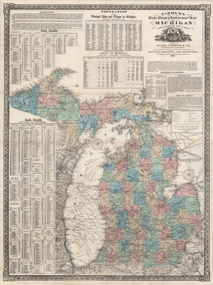
Farmer's Railroad and Township Map of Michigan and Chart of the Lakes.
1873 (dated) 32 x 23.75 in (81.28 x 60.325 cm) 1 : 1140480
1873 (dated) 32 x 23.75 in (81.28 x 60.325 cm) 1 : 1140480
Description
This is an 1868 Silas Farmer railroad and township map of Michigan. Farmer's maps appeared as the federal government was privatizing over 26 million acres of Michigan land for emigration and settlement. With a veritable land rush in progress, both father, John Farmer, and son, Silas Farmer, worked assiduously to keep their maps updated, publishing editions annually and sometimes biannually. Such maps were essential for emigrants, not only for travel, but also to plan frontier life.
Privatizing Michigan
Under the Land Ordinance of 1785 and the Northwest Ordinance of 1787, most of Michigan was officially owned by the Federal government - despite often ignored overlapping claims by various American Indian nations. Although the land was marked for sale to the general public, federal law required it to be fully surveyed first. The gridding of Michigan took roughly 60 years, and by 1840, most of the lower peninsula was platted - the Upper Peninsula took a while longer. The land rush followed when the Territory became a state in 1837. Most of the land was put up for public auction, where it was frequently acquired by wealthy real estate speculators, who then sold it at enormous profit. Other land was put through the agency system, which was in high demand, as advertised here, 'Tenth Thousand Agents Wanted.' The influx of migrants was such that new towns popped up overnight, and existing towns grew rapidly, some into instant cities.A Closer Look
The map embraces modern-day Michigan and parts of Lakes Superior and Huron. The state is divided into counties and surrounded by historical data and statistics of value to prospective emigrants. Navigation routes crisscross Lakes Michigan and Huron, with depth soundings and navigation aids in the most challenging waters. A breakdown of railways appears in the lower left, with lists of stations and distances provided. Census statistics by county from 1840 - 1860 are located at left center. Other information includes discussions of the history of Michigan's name, and the state's salt, mining, and mineral industries.Publication History and Census
This map was created and published by Silas Farmer and Company in 1868. The map is based on an earlier map engraved by Silas' father, John Farmer, prior to his 1859 death. All editions of Farmer's maps are sought after by collectors and are scarce on the market.CartographerS
John Farmer (February 9, 1798 - March 24, 1859) was an American cartographer based in Detroit, Michigan, in the first half of the 19th century. Farmer was born in the town of Half Moon, Saratoga County, New York where he trained to become a school teacher, mastering, among other academic skills, drafting. At the time, Michigan Territory has a shortage of school teachers and, in 1821, recruited Farmer to head the Lancasterian School in Detroit. Farmer supplemented his salary by using his drafting skills to copy manuscript surveys for new settlers arriving in Michigan. This work must have brought him to the attention government officials, who employed him to compile and draft a map of Michigan's first federally funded road. In 1826, he also published, along with Orange Risdon, one of the earliest maps of Michigan. Working in the 1830s, Farmer taught himself engraving in order to issue a second, more detailed map focusing on the southern half of Michigan's lower peninsula. In 1835, he issued an important general map of the Territories of Michigan and Wisconsin, which became one of his most enduring maps, going the various editions for nearly 25 years. Most of his early map plates he sold to J. H. Colton, who republished them under his own name and imprint. In 1844, Farmer issued State of Michigan and the Surrounding Country, the map that most defined his career. It became the essential Michigan map, indispensable for anyone planning to emigrate to Michigan, do business, or even move about the state. He updated and revised this map throughout the remainder of his life. He also issued a rare wall map of Michigan measuring 5 x 6 ft. After his death, in March of 1859, following a long mental decline, the Farmer map plates passed to his widow Rachel, and sons, Silas, Arthur, and John, who continued the business under Farmer's imprint. More by this mapmaker...
Silas Farmer (June 6, 1839 - December 28, 1902) was an American publisher, historian, and author, and son of the famous cartographer John Farmer. Silas began his career working with his father in the family publishing firm, and continued working for the firm after his father's death. Silas published at least three histories of Detroit, Michigan, entitled The History of Detroit and Michigan (1884), All About Detroit (1899), Guide and Souvenir of Detroit (1891). He died suddenly on December 28, 1902 of an apparent heart attack. Silas married Orpha C. Littlefield in 1868. Learn More...
Condition
Very good. Backed on archival tissue for stability. Slight wear along original fold lines.
References
OCLC 31717435.