This item has been sold, but you can get on the Waitlist to be notified if another example becomes available, or purchase a digital scan.
1855 Public Survey Map of Michigan
Michigan-publicsurvey-1855$125.00

Title
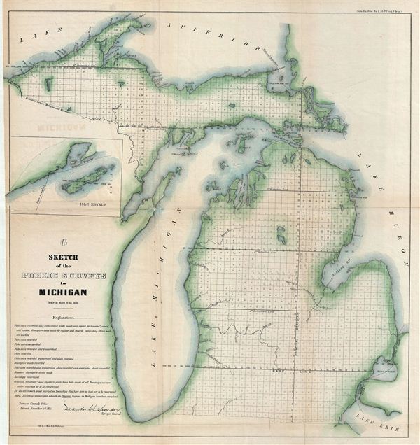
G Sketch of the Public Surveys in Michigan.
1855 (dated) 22 x 21 in (55.88 x 53.34 cm)
1855 (dated) 22 x 21 in (55.88 x 53.34 cm)
Description
This is an attractive example of the 1855 public survey map of Michigan. It covers the entire state of Michigan from Lake Superior to Lake erie, including the entirety of Lake Michigan. An inset map near the left margin details Isle Royale. The state of the Land Survey in this region is illustrated via a series of square plats representing the survey grid. A key in the lower left quadrant offers an explanation of the markings in the survey plats. Numerous rivers and islands and other geographical features are noted. This map was prepared and signed by Leander Chapman, Surveyor- General of Michigan and Indiana, on November 1, 1855. It was engraved by A. Hoen and Company, government printers, in Baltimore, Maryland.
CartographerS
The General Land Office (1812 - 1946) was an independent agency charged with the administration and sale of public lands of the western territories of the United States under the Preemption Act of 1841 and the Homestead Act of 1862. During a time of frenetic energy and rapid westward expansion, the Land Office oversaw the surveying, platting, mapping and eventually the sale of much of the Western United States and Florida. The structural layout of the western United States that we see today, and many of their district and county divisions, are direct result of the early surveying work of the General Land Office. More importantly, as a branch of the Federal Government in Washington D.C. and the only agency able to legally sell and administer public lands in the western territories of the United States, the General Land Office played a pivotal role in consolidating power away from the original states and into the hands of the centralized federal government. The General Land Office was absorbed into the Department of Interior in 1849 and in 1946 merged with the United States Grazing Service to become the Bureau of Land Management. Today the Bureau of Land Management administers the roughly 246 million acres of public land remaining under federal ownership. More by this mapmaker...
August Hoen and Company (fl. c. 1840 - 1981) was a Baltimore based engraving and lithography firm active in the middle part of the 19th century. A. Hoen and Co. was originally founded by Edward Weber under the name 'E. Weber and Company.' Weber died in the early 1850s and his company was taken over by German immigrant August Hoen (18?? - 1886) and his brothers, Henry and Ernest Hoen. As general interest lithographers, the Hoen firm's corpus includes posters, cigar boxes, sheet music covers, and posters as well as maps. They are best known for their pioneering multi-color lithographic techniques. After the death of August Hoen, the business passed on to his son, Albert Hoen. Another son, Earnest A. Hoen, moved to Richmond, Virginia and opened a branch of the firm there where he was granted a charter to produce Civil War era Confederate Currency. Their contributions to the cartographic field are generally in association with engraving and printing work done for Jacob Monk and the U.S. Geological Survey. The Hoen family maintained an active interest in the firm for the next 100 years or so until it finally filed for bankruptcy in 1981. Learn More...
Source
Maps and Views to Accompany Message and Documents 1855-56, (Washington: Nicholson) 1856.
Condition
Very good. Original fold lines visible. Professionally flattened and backed with archival tissue. Some wear and toning on original fold lines.