This item has been sold, but you can get on the Waitlist to be notified if another example becomes available, or purchase a digital scan.
1833 S.D.U.K. Map of Michigan and Wisconsin (w/ Lake Michigan)
MichiganTerritory3-sduk-1833$100.00

Title
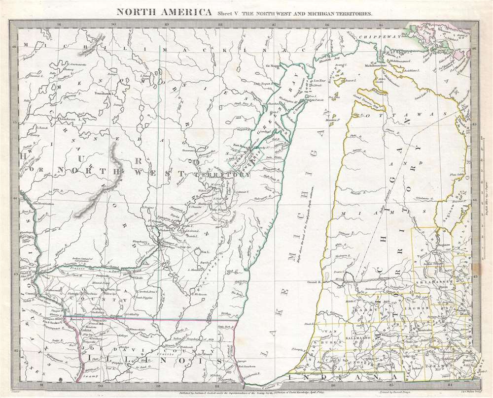
North America Sheet V The North West and Michigan Territories.
1833 (dated) 13 x 15.75 in (33.02 x 40.005 cm) 1 : 1790000
1833 (dated) 13 x 15.75 in (33.02 x 40.005 cm) 1 : 1790000
Description
This is a scarce and important map issued by the Society for the Diffusion of Useful Knowledge, or S.D.U.K., in 1833, depicting Lake Michigan, the second largest of the five Great Lakes, and the only one that lies entirely within the United States. Centered on Lake Michigan, the map depicts the Huron or Northwest Territory (modern day Wisconsin) and the Michigan Territory (modern day Michigan) along with parts of northern Illinois. Territories and counties are identified using outline color. Lake Michigan is slightly malformed and distended on the vertical axis. Several Indian tribes are noted, including the Ottawa and the Chippeway. The Bad Axe River where the Bad Axe Massacre or the Battle of Bad Axe was fought at the end of the Black Hawk War in 1832, a year before this map was issued, is also labeled.
This map was engraved by J. and C. Walker for the Society for the Diffusion of Useful Knowledge and was published by Baldwin and Cradock in 1833.
The Black Hawk War
The Black Hawk War was a battle fought between the United States state militia and the Native American tribes Sauk and Fox. The leader of the Native American tribes was a Sauk warrior Black Hawk, who hoped to resettle on the land that was ceded to the United States in a disputed 1804 treaty. The Bad Axe Massacre took place as an aftermath to the Battle of Wisconsin. In this historic last stand, a mere 60 Sauk warriors held off over 700 U.S. regulars and militia under the command of Henry Dodge while the Indian women and children crossed the river to safety. At dawn the Sauk chief Neapope, concealed in a tree, verbally offered to negotiate surrender. The U.S. soldiers, lacking an interpreter, ignored his plea. Fleeing the aftermath of the Battle of Wisconsin Heights the remaining Sauk, mostly women and children, were cornered near the mouth of Bad Axe River and slaughtered. The war is most remembered for giving young Abraham Lincoln his brief military service.This map was engraved by J. and C. Walker for the Society for the Diffusion of Useful Knowledge and was published by Baldwin and Cradock in 1833.
CartographerS
The "Society for the Diffusion of Useful Knowledge" (1826 - 1848) was a Whiggish organization founded in 1828 at the instigation of idealistic British lord Henry Peter Brougham. The admirable goal of the Society was to distribute useful information via a series of publications to the English working and middle classes. It promoted self-education and the egalitarian sharing of all knowledge. While closely tied to the London University and publishing houses on the order of Baldwin and Cradock, Chapman and Hall, and Charles Knight, the Society failed to achieve its many lofty goals in finally closed its doors in 1848. Most likely the failure of the Society resulted from its publications being too expensive for its intended lower to middle class markets and yet not large and fine enough to appeal to the aristocratic market. Nonetheless, it did manage to publish several extraordinary atlases of impressive detail and sophistication. Their most prominent atlas consisted of some 200 separately issued maps initially published by Baldwin and Cradock and sold by subscription from 1829 to 1844. Afterwards, the Society combined the maps into a single world atlas published under the Chapman and Hall imprint. In its day, this atlas was unprecedented in its quality, scope, and cost effectiveness. Today Society, or S.D.U.K. as it is commonly known, maps are among the most impressive examples of mid-19th century English mass market cartographic publishing available. The S.D.U.K. is especially known for its beautiful and accurately detailed city plans. More by this mapmaker...
John Walker (1787 - April 19, 1873) was a British map seller, engraver, lithographer, hydrographer, geographer, draughtsman, and publisher active in London during the 19th century. Walker published both nautical charts and geographical maps. His nautical work is particularly distinguished as he was an official hydrographer for the British East India Company, a position, incidentally, also held by his father of the same name. Walker's maps, mostly published after 1827, were primarily produced with his brothers Charles Walker and Alexander Walker under the imprint J. and C. Walker. Among their joint projects are more than 200 maps for the influential Society for the Diffusion of Useful Knowledge Atlas (SDUK). In addition they published numerous charts for James Horsburgh and the British Admiralty Hydrographic Office, including Belcher's important map of Hong Kong and Carless' exploratory map of Karachi. The J. and C. Walker firm continued to publish after both Walkers died in the 1870s. Learn More...
Baldwin and Cradock (fl. c. 1810 - 1860) were London based publishers working in the early to mid 19th century. They are best known for their publication of the Society for the Diffusion of Useful Knowledge's ground breaking subscription atlas. They also published John Thomson's magnificent New General Atlas from 1814 - c. 1820. In addition to their cartographic corpus, the firm had wide ranging publishing interests in many other areas, including books, broadsides, and an investment in Blackwoods Magazine. They had their offices at 47 Paternoster Row, London, England. This firm also published under the imprint Baldwin, Cradock, and Joy and Cradock and Joy. Learn More...
Condition
Very good. Even overall toning. Blank on verso.
References
Rumsey 0890.132. Phillips (Atlases) 794. OCLC 11132736.