This item has been sold, but you can get on the Waitlist to be notified if another example becomes available, or purchase a digital scan.
1827 Vandermaelen Map of New Jersey, Delaware and the Mid-Atlantic States
MidAtlantic-vandermaelen-1827$275.00

Title
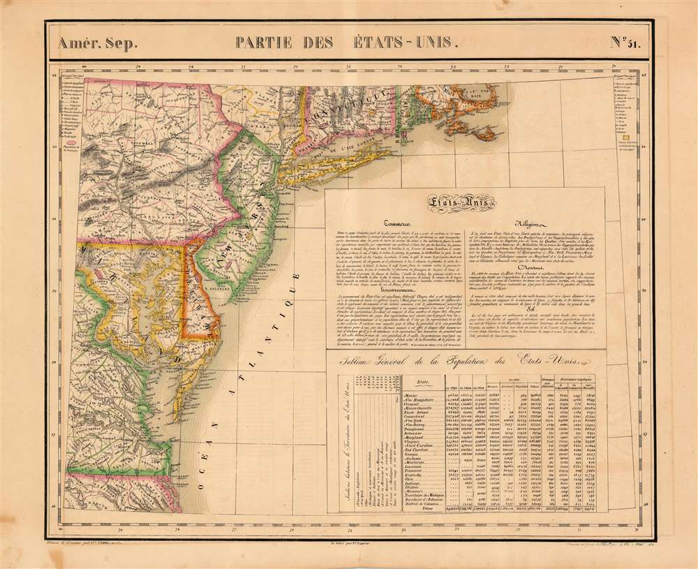
Parties des Etats-Unis. Amer. Sep. 51.
1827 (dated 1825) 19.25 x 22.5 in (48.895 x 57.15 cm) 1 : 1641836
1827 (dated 1825) 19.25 x 22.5 in (48.895 x 57.15 cm) 1 : 1641836
Description
This is the 1827 Vandermaelen map of the Mid-Atlantic United States. Delaware and New Jersey are shown in completion; northeastern North Carolina, the eastern parts of Virginia, Maryland and Pennsylvania, southeastern New York, and the southern extents of Connecticut, Rhode Island and Massachusetts are shown as well. The map includes an extensive text gloss on the United States' trade offerings, religious groups, government, wealth and climate. A table tracks the young nation's population growth from 1790 to 1820, distinguishing between white, slave, and free black populations broken down state-by-state. Native American populations in each state are noted as well. Topography is shown with hachures. In addition to placenames, the map shows the location of Revolutionary War battles, urban populations, and various mineral resources (specific ones are noted using a key)
Publication History
This map appeared in the fourth part, 'Quatrième partie, Amér. sept.' of Vandermaelen's Atlas universel de géographie physique, politique, statistique et minéralogique. The atlas was produced in one edition in 1827; only 810 complete sets were sold. The full set of six volumes appears in eleven institutional collections in OCLC; the 4th volume alone is listed in 9. This map is listed as a separate only in the Clements Library and in Fordham University.Cartographer
Philippe Marie Guillaume Vandermaelen (December 23, 1795 - May 29, 1869) was a Flemish cartographer active in Brussels during the first part of the 19th century. Vandermaelen is created with "one of the most remarkable developments of private enterprise in cartography," namely his remarkable six volume Atlas Universel de Geographie. Vandermaelen was born in Brussels in 1795 and trained as a globe maker. It was no doubt his training as a globe maker that led him see the need for an atlas rendered on a universal scale in order that all bodies could be understood in relation to one another. In addition to his great work Vandermaelen also produced a number of globes, lesser maps, a highly detailed 250 sheet map of Belgium, and several regional atlases. More by this mapmaker...
Source
Vandeermaelen, P. Atlas universel de geographie physique, politique, statistique et mineralogique (Bruxelles, Vandermaelen) 1827.
Condition
Very good condition. Some marginal staining.
References
Rumsey 2212.000.