1966 Phillips Pictorial Map of Lincoln County, Mid-Coast Maine
MidCoastMaine-phillips-1966-2$300.00

Title
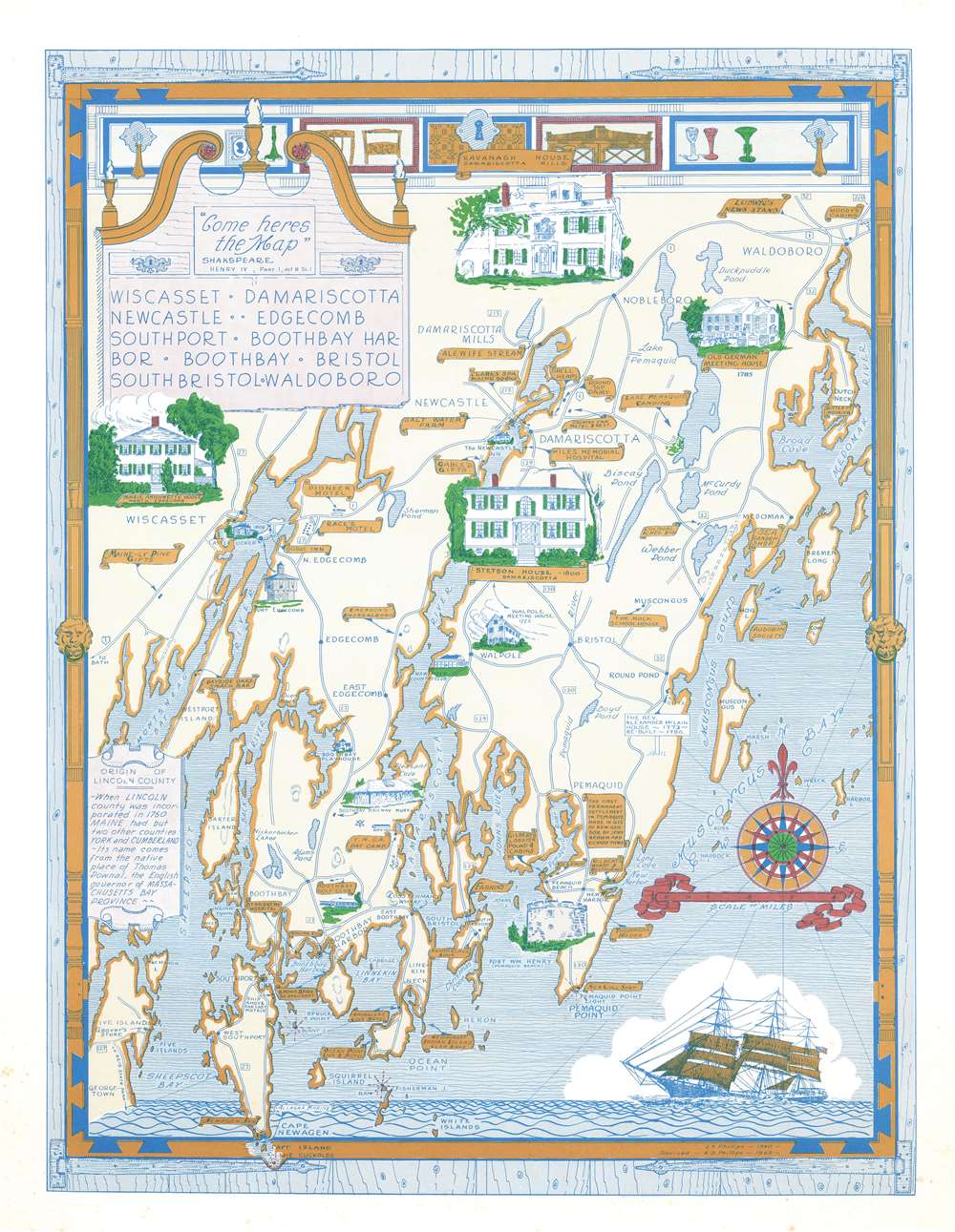
Wiscasset. Damariscotta. Newcastle. Edgecomb. Southport. Boothbay Harbor. Boothbay. Bristol. South Bristol. Waldoboro.
1966 (dated) 20 x 15.25 in (50.8 x 38.735 cm) 1 : 84480
1966 (dated) 20 x 15.25 in (50.8 x 38.735 cm) 1 : 84480
Description
This is a 1966 Augustus Dewey Phillips pictorial map of Lincoln, County, Maine depicting from Montsweag Bay to Muscongus Bay and from Waldoboro to Cape Island. Phillips highlights local history, the county's historic whaling towns, and identifies many local businesses. The towns of Damariscotta, Waldoboro, Wiscasset, Boothbay Harbor, Newcastle, Boothbay, and others appear. Vignettes illustrate important historic structures, including the Marie Antoinette House in North Edgecomb, Castle Tucker, the Stetson House in Damariscotta, the Boothbay Railway Museum, and the Kavanagh House in Damariscotta Mills. The Round Top Dairy, Cable's Gifts, the Rock Schoolhouse, Emerson's Smorgasbord, the Boothbay Golf Club, and the Bayside Oaks Snack Bar represent a sampling of the local establishments. A text along the left provides a short history of Lincoln County's founding.
Publication History and Census
This is an example of the 1966 revised edition of this map, executed by Augustus Dewey Phillips and published in 1966. Luther Savage Phillips published the first edition in 1940. We note three examples of the present edition are cataloged in OCLC, located at Harvard College, the Osher Map Library at the University of Southern Maine, and the University of Maine at Orono. We have also located an example in the collection of the Northeast Harbor Library in Northeast Harbor, Maine.CartographerS
Augustus Dewey Phillips (May 6, 1898 - December 14, 1975), a.k.a. 'Gus', was an American artist, cartographer, and publisher. Born on Mount Desert Island, Maine, as a boy Augustus and his brother Luther Savage Phillips (1891 - 1960) helped their dad in a variety of odd jobs, including maintaining a boat rental business and harvesting and selling ice. Augustus graduated from Hebron Academy and then attended the University of Maine for a short time. After leaving university, Phillips became a Maine Guide and worked as a carpenter and draftsman in the South Portland and Boothbay Harbor ship and boat yards. The brothers traveled together widely throughout Maine. Luther went on to start a popular map and postcard business out of Northeast Harbor, Maine. After Luther died in 1960, Augustus took over the map businesses. In a tragic turn of events, in 1973 an out of control bush fire destroyed the Phillips studio and much of the surviving stock, making all Phillips' maps issued prior to that date rare. His passion for landscapes helped Augustus create his own map style. Augustus expanded the business and continued making new maps until he died in 1975. Augustus' son, Donald Beekman Phillips (1935 - 2009) continued the business after his father's death. Augustus married Mary Fletcher on April 26, 1922, with whom he had four children. More by this mapmaker...
Luther Savage Phillips (May 10, 1891 - 1960) was an American map maker, photographer, architect, and postcard publisher, and is arguably Maine's most significant pictorial cartographer. Born on Mount Desert Island (Acadia National Park), Maine, Phillips studied at Phillips Andover Academy before spending two years at Yale. He graduated with a Bachelor of Science degree from MIT in 1914. In October 1917 Phillips enlisted in the U.S. Navy as a Coxswain and was commissioned as an Ensign in 1918, when he was sent to the U.S. Naval Academy at Annapolis, Maryland. He was later assigned to the U.S.S. Rhode Island and sailed with the ship on a mission to Archangel on April 11, 1919. After his time in the Navy, Phillips established a successful postcard publishing business and became a well-known pictorial mapmaker. Much of his work focused on the Maine coast in the vicinity of Bar Harbor. Based in Northeast Harbor, Mount Desert Island, Maine, his company, 'Map of Maine' produced local pictorial maps for the tourist market. He would tour the state promoting and selling his work, along with his scenic postcards. After Phillips died in 1960, in Togus, Maine, his brother, Augustus 'Gus' Dewey Phillips (1898 - 1975) took over the map and postcard business, which was then continued by his nephew Donald Phillips (1935 - 2009). In a tragic turn of events, in 1973 an out of control bush fire destroyed the Phillips studio and much of the surviving stock, making all Phillips' maps issued prior to that date rare. Philipps married Olympia Meimari on March 24, 1921 in Annapolis. It is unclear whether Olympia died or the couple divorced, but it is known that Phillips remarried, to Mary J. Merrill in 1935. Learn More...
Condition
Very good. Exhibits light foxing in margin.
References
Northeast Harbor Library 3598. OCLC 173220010.