This item has been sold, but you can get on the Waitlist to be notified if another example becomes available, or purchase a digital scan.
1841 Jomini Map of Northern Italy Lake Garda (French Revolutionary Wars)
MilitaireArmeeItalie-jomini-1839$225.00

Title
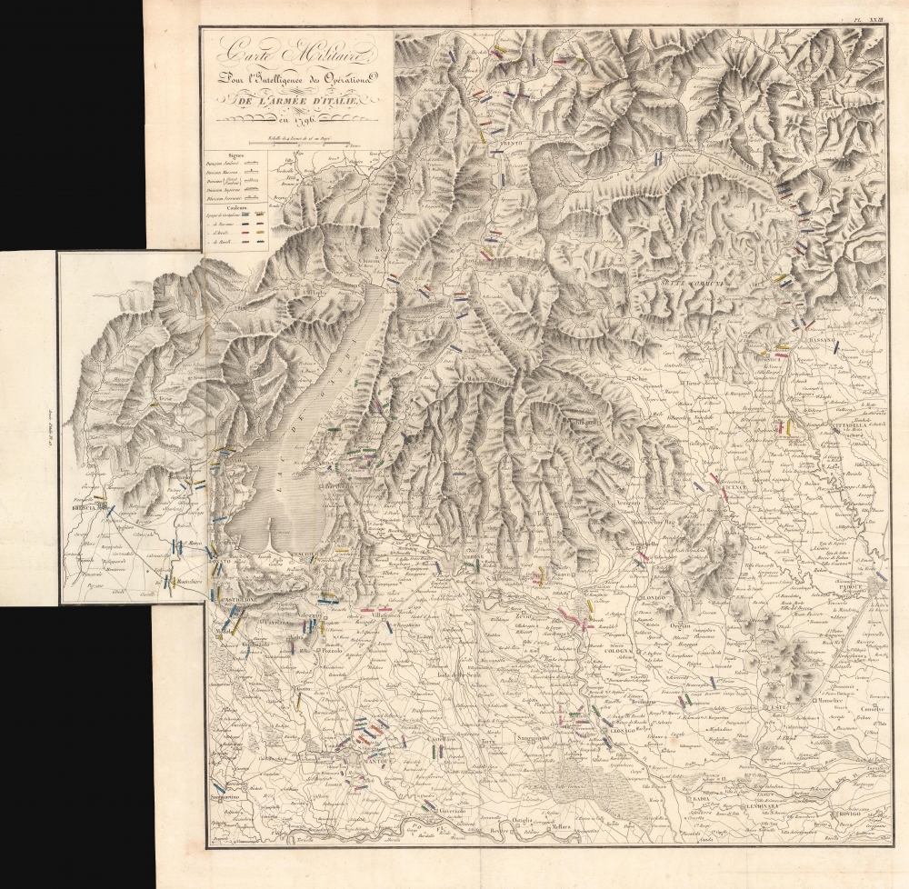
Carte Militaire Pour l'Intelligence des Opérations de l'Armée d'Italie en 1796.
1839 (undated) 22.75 x 23 in (57.785 x 58.42 cm) 1 : 260000
1839 (undated) 22.75 x 23 in (57.785 x 58.42 cm) 1 : 260000
Description
This is an 1839 Antoine Henri Jomini map of northern Italy in the vicinity of Lake Garda during the French Revolutionary Wars. Highlighting events during 1796 - 1797, this map focuses on the siege of Mantua (1796 - 1797) and the four Austrian relief attempts.
A Closer Look
Depicting northern Italy from north of Trento to Mellara and Rovigo and from Brescia to Padua, cities, towns, and villages throughout are labeled. Lake Garda appears on the left not far from the fold-out extension along the left side. Hand colored bars represent French and Austrian troops, with colors representing divisions during the four relief campaigns. A key in the upper left provides explains the notations and identifies the relief attempt they correspond with. All four attempts are identified using the last battle of each one (Castiglione, Bassano, Arcole, and Rivoli).The Siege of Mantua
The siege of Mantua (July 4, 1796 - February 2, 1797) was part of the 1796 - 1797 Italian Campaign during the War of the First Coalition (1792 - 1797). Napoleon Bonaparte, then a relatively unknown upstart in the French army, was appointed commander in chief of the Italian Army on March 2, 1796. His appointment was seen as a political move by the Directors of the First Republic, but he proved himself to be an extraordinary commander. He quickly defeated Piedmont and knocked them out of the war. Then, after a back-and-forth campaign against the Austrians, he besieged an Austrian force in Mantua. The Austrians launched four relief attempts of their besieged comrades, but each time Bonaparte and his army defeated them, eventually leading to the surrender of the Austrian army in Mantua on February 2. Then, Bonaparte launched an invasion of Austria in March, which forced Austria's complete surrender, ending the War of the First Coalition.Publication History and Census
This map was engraved by J.B. Bielaerds for publication in General Antoine Henri Jomini's Atlas pour the Traité des Grandes Opérations Militaires as plate 23 and published by J.B. Petit in Brussels in 1839. We note two cataloged examples of the separate map, which are part of the collections at the Newberry Library and the Bayerische Staatsbibliothek. The atlas is cataloged as being part of 10 institutional collections. Both are rare on the private market. Jomini published several editions of his Traité des Grandes Opérations Militaires, some of which were accompanied by atlases. As far as we can tell, the only edition that included the present map is the 1839 edition.Cartographer
Antoine-Henri Jomini (March 6, 1779 – March 22, 1869) was a Swiss military officer who became one of the most influential military thinkers of the 19th century. An enthusiastic supporter of the French Revolution and the Helvetic Republic, Jomini quickly rose through the ranks of the republic's military hierarchy before moving to Paris and writing a book titled Traité des grandes operations militaires. Jomini's work caught the attention of Michel Ney, one of Napoleon's leading generals, who brough Jomini onto his staff. Later, due to his research of Frederick the Great's military tactics, Napoleon brought Jomini onto his staff during the War of the Fourth Coalition (1806 – 1807), in which Jomini was highly decorated. Serving for a time in both the French and Russian armies (while they were nominal, uneasy allies after the 1807 Treaty of Tilsit), Jomini was torn when war broke out between the empires in 1812 and tried to avoid field service on either side, leading to his earning enemies among officers of both armies. Still, he accompanied the Russians into Paris and tried unsuccessfully to prevent the execution of Ney. He later attended the Congress of Vienna and lived in Russia, training military officers and advising the Russian military in its battles with the Ottomans. Upon retirement in 1829, he moved to Brussels but returned to advise the Russians during the Crimean War. He advocated all along for greater understanding and cooperation between France and Russia, while also remaining a dedicated Swiss patriot. Jomini's writings were deeply influential on subsequent military thinking, including among the leading generals of the American Civil War, who had studied his works at West Point. Though less famous today, in the 19th century Jomini was seen as an essential accompaniment to Carl von Clausewitz, with whom he had several key points of disagreement. However, both thinkers ultimately concluded that war was more an art than a science, and that unpredictable and unquantifiable factors such as morale and leadership mattered far more than numbers of troops or ammunition. More by this mapmaker...
Source
Jomini, A.H., Atlas pour the Traité des Grandes Opérations Militaires (Brussels: Petit) 1839.
Condition
Very good. Light wear along original fold lines.
References
OCLC 165113895. OCLC 1338046200 (Atlas).