1860 Stevens U.S. Pacific Railroad Survey Map of Montana
MilktoColumbia-stevens-1860
Title
1860 (undated) 24.5 x 61.5 in (62.23 x 156.21 cm) 1 : 600000
Description
A Closer Look
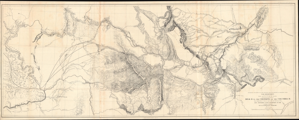
Spanning three conjoined sheets and covering the region between the headwaters of the Missouri and Columbia Rivers, this map records mountains, buttes, rivers, trading posts, forts and cantonments, religious missions, and the occasional settlement (Coeur d'Alene towards left, both 'old' and 'new' Walla Walla at far left). Some features, especially bodies of water, are named with approximations of indigenous names.In addition to the Stevens Expedition (with its various branches), the routes of other explorers and army officers are traced, including those of John Mullan (an Army officer), R. H. Landsdale (an Indian Agent), and Abiel Tinkham (an Army officer famous for crossing the Continental Divide at today's Glacier National Park, at top here). Interesting comments are provided throughout, such as 'common hunting ground of Western and Blackfeet Indians' just to the left of the title.
The Stevens Expedition
The Stevens Expedition was a major survey and exploratory mission aimed at finding a practical route for a northern transcontinental railroad, largely through present-day Montana. Stevens was the newly appointed governor of Washington Territory after having led the U.S. Coast Survey. In addition to taking up the territorial governorship, he was commissioned by the U.S. government to explore feasible railroad routes and to gather valuable scientific and geographical data on the largely uncharted northern territories. The expedition produced some of the earliest detailed maps and geographical information on the regions of Montana and Washington Territory, as well as extensive notes on their flora and fauna, landscape, and peoples (the group included three naturalists and two artists).Stevens' governor duties also included the title of Superintendent of Indian Affairs for the Washington Territory, and the railroad survey brought his team (which included Fred Burr, son of noted early 19th-century cartographer David Burr) into contact with the Blackfeet and other Native American groups, with whom Stevens would have a tumultuous relationship. While producing the survey, Stevens and his team relied upon French trappers and Métis members of local tribes, and treaties were negotiated to permit the surveyors' passage (one 'treaty ground' is noted near the eventual location of Missoula near center). Starting from St. Paul, Minnesota, Stevens' team surveyed as far west as the Spokane River, where they met a western survey group led by George McClellan, later the commander of Union forces in the early phase of the U.S. Civil War.
The Pacific Railroad Surveys
Following the annexation of Texas and Upper California at the end of the Mexican-American War, the United States became a coast-to-coast empire. The 1849 California Gold Rush led to rapid Westward Expansion and a population boom on the west coast. Connecting California to the Eastern Seaboard with an overland railroad route was essential to the growth and stability of the country.Hopes for the railroad were high, and Congress authorized a series of preparatory surveys of practical routes, known collectively as the Pacific Railroad Surveys (1853 - 1855). The resulting reports, including maps, plates, charts, and graphs, provided an incredible body of data about the ecology and cultures of the western regions of North America soon after their incorporation into the United States. The present view, along with others accompanying the surveys, highlight the fundamental duality of the West, a harsh and hostile environment that is simultaneously indescribably beautiful.
While all agreed on the importance of a Pacific Railroad, not everyone in power was ready to act. Lobby groups published propaganda to illustrate the benefits of the route, and ultimately, in 1862, Congress passed the Pacific Railway Act, leading to the chartering of the Union Pacific Railroad Company, charged with constructing the route. Nonetheless, by this time, the United States was fully embroiled in the American Civil War (1861 - 1865), which further stymied construction. It was not until May 10, 1869, that the robber baron and railroad tycoon Leland Stanford drove the Golden Spike at Promontory Summit, Utah Territory, linking the eastern and western spurs of the Pacific Railroad, creating the first transcontinental railroad.
Publication History and Census
This map was prepared by Isaac Ingalls Stevens and was printed by Sarony, Major, and Knapp. It appeared in Report of Explorations for a Route for the Pacific Railroad near the 47th and 49th Parallels of North Latitude, from St. Paul, Minnesota, to Puget Sound, which was issued in two volumes with several printings in the late 1850s. This map is independently cataloged among the holdings of 9 institutions in OCLC.CartographerS
Isaac Ingalls Stevens (March 25, 1818 – September 1, 1862) was an American military officer and politician. He served as governor of the Territory of Washington from 1853 to 1857, and later as its delegate to the United States House of Representatives; he was also Superintendent of Indian Affairs. He was a polarizing figure, whose tenure as governor overwhelms Washington's territorial history; accounts of him condemn or applaud. A New Englander, the diminutive Stevens graduated from Phillips Academy in 1833. He attended West Point, where he graduated at the top of his class. He became career military. He was adjutant of the Corps of Engineers during the Mexican-American War, performing with distinction in combat. He swiftly earned wartime promotions to Captain and Major, and received severe wounds in combat. He would in 1851 publish a book on his experiences during the war. Between 1841 and 1849 he was superintendent of fortifications on the New England coast, and was given command of the coast survey until 1853. His support of fellow Mexican War veteran Franklin Pierce led him to be rewarded by the new President Pierce by being made governor and Superintendent of Indian Affairs for the new Washington Territory. Stevens also undertook to use his travel west as an opportunity to survey a railroad route across the northern United States (he was an experienced engineer, although his connections with President Pierce and Secretary of War Jefferson Davis doubtless aided his bid.)He would publish the results of his survey in 1855. His governorship would prove controversial. Aggressive in diplomacy as well as war, he compelled Native American tribes of Washington Territory by both intimidation and force, and was not above forging signatures on treaties. His tenure resulted in the Treaties of Medicine Creek, Treaty of Hellgate, Treaty of Neah Bay, Treaty of Point Elliott, Point No Point Treaty, and Quinault Treaty. He imposed martial law to remove dissent from both the Indians and Whites who opposed his policies. He jailed opposing judges, and raised a private army - for which he was convicted for contempt of court, rebuked by the President of the United States. Despite opposition, he was popular enough among white settlers in the Territory to be elected as the territory's delegate to the United States Congress in 1857 and 1858. During the American Civil War, he held several Union commands and was - at the time of his death - under consideration for appointment to command the Army of Virginia. He was killed at the Battle of Chantilly, leading his men from the front, carrying the fallen colors of one of his regiments against Confederate positions. He was posthumously promoted to Major General. More by this mapmaker...
The Pacific Railroad Surveys (1853 - 1855) were established in 1853 with the goal of identifying the best possible routes for a transcontinental railroad from the Mississippi to the Pacific. The need for transcontinental railroad made itself evident shortly after the California Gold rush when the westward expansion was at its heights. The federal government, acting under the Sectary of War, Jefferson Davis (of Civil War fame), initiated a series of expeditions of the western territories. These expeditions included surveyors, cartographers, artists, zoologists, botanists and geographers. The resultant work, a 12 volume compendium entitled Reports of Explorations and Surveys, to ascertain the most practicable and economical route for a railroad from the Mississippi River to the Pacific Ocean eventually led to the constructions of several different transcontinental railroads. Learn More...
Napoleon Sarony (March 9, 1821 - November 9, 1896) was a dashingly handsome Canadian-American lithographer and publisher active in New York in the mid to late 19th century. Sarony was born in Quebec and emigrated to New York City in 1835. He apprenticed under Henry Robinson (fl. 1830/33 - 1850) before working as a lithograph artist for Nathaniel Currier (1813 - 1888). In 1846, he partnered with Currier's apprentice lithographer Henry B. Major to establish the firm of 'Sarony and Major.' From offices at 117 Futon Street, they published under this imprint until roughly 1853, when Sarony split off on his own under the imprint 'Sarony and Co.', still at 117 Fulton. At the time 'and Co.' probably meant Joseph Fairchild Knapp (1832 - 1891), Sarony's apprentice, and Richard C. Major, possibly Henry Major's son. In 1857, a new imprint was established as 'Sarony, Major and Knapp'. According to an advertisement in the New York Times (Feb 16, 1864), Sarony had invested in the business at founding, but was not an active partner, possibly because he was traveling in Europe. It is unclear why Sarony's name was maintained, possibly to capitalize on his fame, as a honorific, or possibly because he owned a major stake. They published under this imprint until 1863, becoming a major concern at 449 Broadway. Sarony's name was formally removed from the partnership in 1863. At the time he was traveling in Europe, mastering the most advanced color lithography and photographic techniques. He is known to have worked in France, Germany, and England. He returned to New York in the 1860s, establishing a photography company at 37 Union Square that became famous for its portraits of late-19th-century American theater icons. In 1891, Sarony, hoping to capitalize on Sarah Bernhardt's fame as 'Cleopatra', paid the stage actress 1,500 USD to sit for a photo session, the modern-day equivalent of 20,000 USD - suggesting a highly prosperous business. His son, Otto Sarony (1850–1903), continued the family business as a theater and film star photographer. As an aside, Sarony's second wife, Louie Sarony, was a known eccentric who would reportedly dress in elaborate rented costumes to walk around Washington Square each afternoon. Learn More...


