This item has been sold, but you can get on the Waitlist to be notified if another example becomes available, or purchase a digital scan.
1865 U.S. Coast Survey Map of the Mississippi River from Cairo, IL to St. Marys, MO
MississippiRiver-uscs-1865$350.00

Title
Mississippi River from Cairo Illinois to St. Mary’s Missouri in VI Sheets. Reconnaissance for the use of the Mississippi Squadron under the command of Acting Rear Admiral S.P.L.E.E, U.S.N. By the part of E. H. Gerdes, Assistant; assigned by A.D. Bache, Supdt. United States Coast Survey.
1865 (dated) 23 x 16 in (58.42 x 40.64 cm)
1865 (dated) 23 x 16 in (58.42 x 40.64 cm)
Description
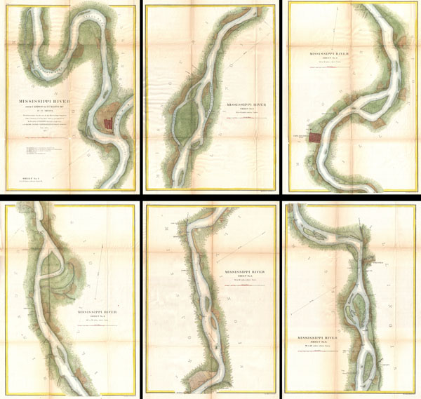
This is an important and rarely seen complete set of six charts from the 1865 U.S. Coast Survey mapping of the Mississippi River. Prepared by F. H. Gerdes, this map set details the territory from Cairo Illinois to St. Mary's Missouri. During the American Civil War this was a critical artery, the control of which would profoundly influence the course of the war. The cartographers of the United States Coast Survey, most of whom where Union men, understood that a proper mapping of the region was essential to control of the River. Gerdes spent part of 1864 preparing this map set for use by the Mississippi River Squadron, a flotilla of ironclads that would play a role in several important Civil War battles. Unfortunately, it is unlikely that Squadron ever actually saw these charts as it was disbanded in 1865, the same year the chart set was competed.
Each chart focuses on a particular part of the river, but in general are highly detailed with regard to the towns, navigation points, villages, plantations, critical resources, and farms that lined the river. Cairo, Cape Girardeau City, and of course St. Marys are exceptionally well detailed. Identifies the course of the Illinois Central Railroad as it enters Cairo. Sounding and a recommended course noted along the center of the river.
This map was surveyed by F. H. Gerdes and A. T. Mosman. The topography is the work of T. D. Bowie and F. W. Perkins. Drafted by J. B. Adamson. Published in 1865 under the direction of A.D. Bache, superintended to the U.S. Coast Survey. These important maps occasionally appear in separately, but rarely as a set.
CartographerS
The Office of the Coast Survey (1807 - present) founded in 1807 by President Thomas Jefferson and Secretary of Commerce Albert Gallatin, is the oldest scientific organization in the U.S. Federal Government. Jefferson created the "Survey of the Coast," as it was then called, in response to a need for accurate navigational charts of the new nation's coasts and harbors. The spirit of the Coast Survey was defined by its first two superintendents. The first superintendent of the Coast Survey was Swiss immigrant and West Point mathematics professor Ferdinand Hassler. Under the direction of Hassler, from 1816 to 1843, the ideological and scientific foundations for the Coast Survey were established. These included using the most advanced techniques and most sophisticated equipment as well as an unstinting attention to detail. Hassler devised a labor intensive triangulation system whereby the entire coast was divided into a series of enormous triangles. These were in turn subdivided into smaller triangulation units that were then individually surveyed. Employing this exacting technique on such a massive scale had never before been attempted. Consequently, Hassler and the Coast Survey under him developed a reputation for uncompromising dedication to the principles of accuracy and excellence. Unfortunately, despite being a masterful surveyor, Hassler was abrasive and politically unpopular, twice losing congressional funding for the Coast Survey. Nonetheless, Hassler led the Coast Survey until his death in 1843, at which time Alexander Dallas Bache, a great-grandson of Benjamin Franklin, took the helm. Bache was fully dedicated to the principles established by Hassler, but proved more politically astute and successfully lobbied Congress to liberally fund the endeavor. Under the leadership of A. D. Bache, the Coast Survey completed its most important work. Moreover, during his long tenure with the Coast Survey, from 1843 to 1865, Bache was a steadfast advocate of American science and navigation and in fact founded the American Academy of Sciences. Bache was succeeded by Benjamin Pierce who ran the Survey from 1867 to 1874. Pierce was in turn succeeded by Carlile Pollock Patterson who was Superintendent from 1874 to 1881. In 1878, under Patterson's superintendence, the U.S. Coast Survey was reorganized as the U.S. Coast and Geodetic Survey (C & GS) to accommodate topographic as well as nautical surveys. Today the Coast Survey is part of the National Oceanic and Atmospheric Administration or NOAA as the National Geodetic Survey. More by this mapmaker...
Ferdinand H. Gerdes (September 15, 1809 - June 27, 1884) was one of the most active members of the U.S. Coast Survey team. His most important work includes several surveys of New York Harbor as well as detailed surveys of Florida, the Gulf Coast, and up the Mississippi River. Gerdes was born in Hanover, Germany (Prussia) and relocated to the United States sometime before 1836, when he joined he fledgling U.S. Coast Survey as an Sub-assistant under Hassler. From 1841 - 1844 he surveyed the New Jersey, Maryland, Delaware Bay Region. In 1844 he was assigned to the Gulf Coast, where he produced his most important and pioneering work. During the American Civil War, like most of the members of the Coast Survey, Gerdes was strongly pro-Union and worked diligently during the Civil War to provide Union commanders accurate surveying and cartographic materials. Gerdes is known to have commanded the ‘Sachem' and, during the Civil War, was heavily engaged with Union efforts to map and ultimately control, the Mississippi River. Following the war he produced detailed surveys of the Passes of the Mississippi. His health and age catching up on him, Gerdes retired to New York, where he completed additional surveys of long island as late as 1883, a year before his death. Learn More...
Source
Report of the Superintendant of the United States Coast Survey, Washington, (1867 Supplement to the 1865 edition).
Condition
Good. All sheets exhibit wear, discoloration, and verso repairs along the original fold lines - as is common with USCS Report maps. A couple of sheets have margin extensions.