1662 Blaeu map of the Northern Italian region of Emilia-Romagna
Modena-blaeu-1662$750.00
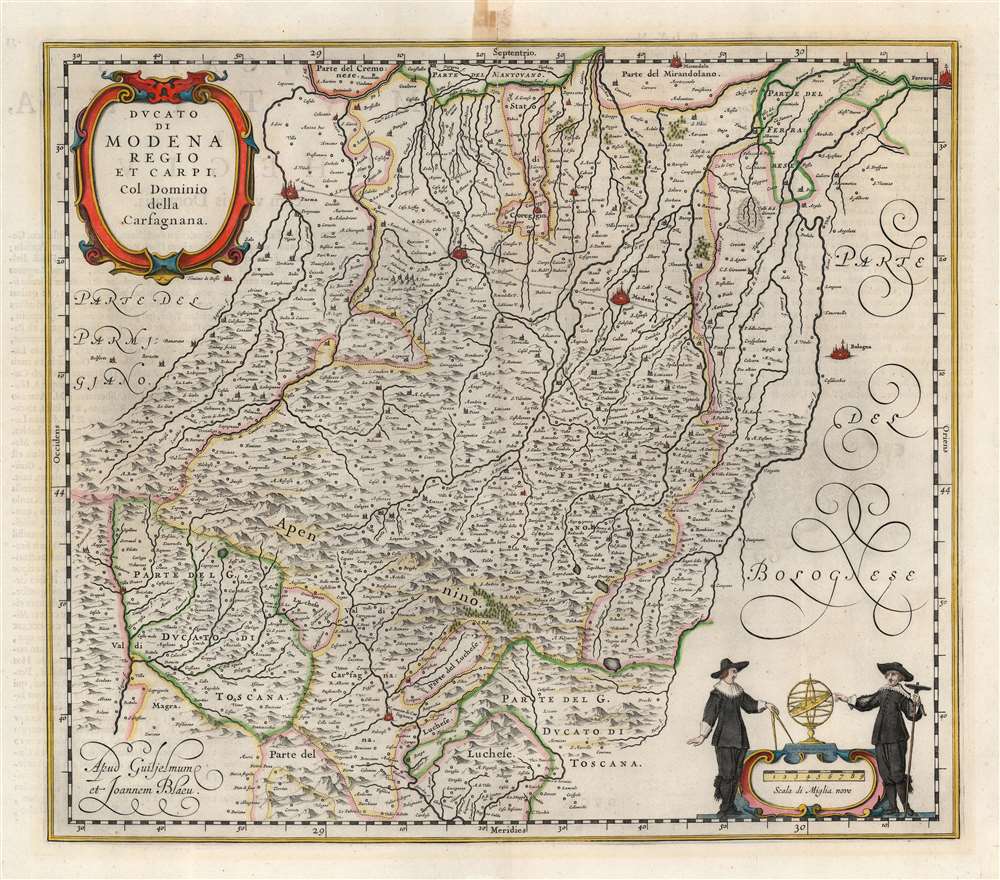

Title
Ducato di Modena Regio et Carpi Col Dominio della Carfagnana.
1662 (undated) 15.5 x 18 in (39.37 x 45.72 cm) 1 : 325000
1662 (undated) 15.5 x 18 in (39.37 x 45.72 cm) 1 : 325000
Description
A beautiful, original color example of Willem and Joan Blaeu's map of the Emilia-Romagna region, focusing on the cities of Parma, Regio, and Modena. At the north and east extremes of the map, the cities of Mirandola, Ferrara, and Bologna are pictured as well. The superb copperplate is the product of the house of Blaeu at their height, with its delicately engraved cities, pictorially represented mountains and forests, and meticulously detailed cities, towns, and villages. Among its details is a road, connecting Parma, Regio, and Moden. The other regional maps would continue this road to Piacenza and Bologna, and beyond. Though not named, the course of the road corresponds to the Roman road known as the Via Aemilia.
From the First Atlas of Italy
The geographical detail is faithfully drawn from the identically-titled map drawn by Giovanni Antonio Magini, and published by his heir Fabio in 1620. Magini's posthumous work would stand throughout the 17th century as the most authoritative source for the mapping of Italy. This engraving, however, is executed with far greater skill than its source. Blaeu's fine work includes an elegantly framed title cartouche. A scale cartouche in the lower right is flanked by two geographers (identifiable by their tools - a compass, a backstaff, and an armillary sphere.)Publication History and Census
This map was engraved by Joan Blaeu for inclusion in 1640 Atlas edition. The map appeared in all later editions of the Blaeu atlases, including Joan Blaeu's monumental Atlas Maior. The present example corresponds to the 1662 Latin edition of that work. It is well represented in institutional collections.CartographerS
Willem Janszoon Blaeu (1571 - October 18, 1638), also known as Guillaume Blaeu and Guiljelmus Janssonius Caesius, was a Dutch cartographer, globemaker, and astronomer active in Amsterdam during the late 16th and early 17th centuries. Blaeu was born 'Willem Janszoon' in Alkmaar, North Holland to a prosperous herring packing and trading family of Dutch Reformist faith. As a young man, he was sent to Amsterdam to apprentice in the family business, but he found the herring trade dull and instead worked for his cousin 'Hooft' as a carpenter and clerk. In 1595, he traveled to the small Swedish island of Hven to study astronomy under the Danish Enlightenment polymath Tycho Brahe. For six months he studied astronomy, cartography, instrument making, globe making, and geodesy. He returned to Alkmaar in 1596 to marry and for the birth of his first son, Johannes (Joan) Blaeu (1596 – 1673). Shortly thereafter, in 1598 or 1599, he relocated his family to Amsterdam where he founded the a firm as globe and instrument makers. Many of his earliest imprints, from roughly form 1599 - 1633, bear the imprint 'Guiljelmus Janssonius Caesius' or simply 'G: Jansonius'. In 1613, Johannes Janssonius, also a mapmaker, married Elizabeth Hondius, the daughter of Willem's primary competitor Jodocus Hondius the Elder, and moved to the same neighborhood. This led to considerable confusion and may have spurred Willam Janszoon to adopt the 'Blaeu' patronym. All maps after 1633 bear the Guiljelmus Blaeu imprint. Around this time, he also began issuing separate issue nautical charts and wall maps – which as we see from Vermeer's paintings were popular with Dutch merchants as decorative items – and invented the Dutch Printing Press. As a non-Calvinist Blaeu was a persona non grata to the ruling elite and so he partnered with Hessel Gerritsz to develop his business. In 1619, Blaeu arranged for Gerritsz to be appointed official cartographer to the VOC, an extremely lucrative position that that, in the slightly more liberal environment of the 1630s, he managed to see passed to his eldest son, Johannes. In 1633, he was also appointed official cartographer of the Dutch Republic. Blaeu's most significant work is his 1635 publication of the Theatrum orbis terrarum, sive, Atlas Novus, one of the greatest atlases of all time. He died three years later, in 1638, passing the Blaeu firm on to his two sons, Cornelius (1616 - 1648) and Johannes Blaeu (September 23, 1596 - December 21, 1673). Under his sons, the firm continued to prosper until the 1672 Great Fire of Amsterdam destroyed their offices and most of their printing plates. Willem's most enduring legacy was most likely the VOC contract, which ultimately passed to Johannes' son, Johannes II, who held the position until 1617. As a hobbyist astronomer, Blaeu discovered the star now known as P. Cygni. More by this mapmaker...
Joan (Johannes) Blaeu (September 23, 1596 - December 21, 1673) was a Dutch cartographer active in the 17th century. Joan was the son of Willem Janszoon Blaeu, founder of the Blaeu firm. Like his father Willem, Johannes was born in Alkmaar, North Holland. He studied Law, attaining a doctorate, before moving to Amsterdam to join the family mapmaking business. In 1633, Willem arranged for Johannes to take over Hessel Gerritsz's position as the official chartmaker of the Dutch East India Company, although little is known of his work for that organization, which was by contract and oath secretive. What is known is his work supplying the fabulously wealthy VOC with charts was exceedingly profitable. Where other cartographers often fell into financial ruin, the Blaeu firm thrived. It was most likely those profits that allowed the firm to publish the Theatrum Orbis Terrarum, sive, Atlas Novus, their most significant and best-known publication. When Willem Blaeu died in 1638, Johannes, along with his brother Cornelius Blaeu (1616 - 1648) took over the management of the Blaeu firm. In 1662, Joan and Cornelius produced a vastly expanded and updated work, the Atlas Maior, whose handful of editions ranged from 9 to an astonishing 12 volumes. Under the brothers' capable management, the firm continued to prosper until the 1672 Great Amsterdam Fire destroyed their offices and most of their printing plates. Johannes Blaeu, witnessing the destruction of his life's work, died in despondence the following year. He is buried in the Dutch Reformist cemetery of Westerkerk. Johannes Blaeu was survived by his son, also Johannes but commonly called Joan II, who inherited the family's VOC contract, for whom he compiled maps until 1712. Learn More...
Giovanni Antonio Magini (June 13, 1555 - February 11, 1617) was an Italian astronomer, astrologer, cartographer, and mathematician. Born in Padua, he completed his studies in philosophy in Bologna in 1579. In 1588 he was chosen over Galileo Galilei as the chair of mathematics at the University of Bologna after the death of Egnatio Danti. Magini was a prolific writer, putting forth theories of celestial motion (he was a supporter of a geocentric solar system), the use of quadrants in surveying and astronomy, and trigonometry. In 1608, Magini produced the first map of Italy to improve on that of Gastaldi: his meticulously researched and beautifully engraved 8-sheet Italia Nuova was hugely influential: upon its publication, Blaeu promptly copied it to produce his own wall map of Italy; the rest of the mapmaking establishment swiftly followed suit. Consequently, virtually every 17th century map of Italy can be identified as a derivative of Magini's monumental achievement. His atlas, Atlante geografico d’Italia, was published posthumously by his son in 1620. This work was intended to include maps of every Italian region with exact nomenclature and historical notes. He also served as court astrologer for the Duke of Mantua. Learn More...
Source
Blaeu, J., Atlas Maior, (Amsterdam: Blaeu) 1662.
In 1662 Joan Blaeu published his masterwork, which has been described as 'the greatest and finest atlas ever published' (Verwey, 1952): his monumental, eleven-volume Atlas Maior. This contained nearly six hundred maps, more than two hundred in excess of the Blaeus' mainstay the Atlas Novus. The former work already being renowned for the quality and beauty of its maps, Blaeu not only added copious material but improved the sophistication of his work: many of the newly-added maps utilized larger-sized presses and sheets, and the artistry applied to the engravings was often far superior to that of the earlier maps in the atlas - many of which by now were 30, and some more than 50 years old. Blaeu's Atlas Maior was published from 1662 to 1672, consisting of some 594 maps compiled into upwards of 9 volumes with some editions containing as many as 12 volumes. This triumphant work's publishing life was cut violently short when, in 1672, the Blaeu's mammoth workshop was destroyed by fire; surviving stock would be sold at auction between 1674 and 1677, occasionally appearing under the imprint of later Dutch printers such as Pieter Schenk and Pieter Mortier. The maps added to the Atlas Maior, owing to their tragically short publishing life, are among the hardest-to-find of the Blaeu maps.
Condition
Very good. Marginal mends at upper centerfold and lower right corner not impacting printed image; some marginal staining at upper centerfold. Else excellent with bright original hand color.
References
OCLC 556641163. Rumsey 10017.517. van der Krogt, P., Koeman's Atlantes Neerlandici, Volume 2, #7270:2 2:601.