This item has been sold, but you can get on the Waitlist to be notified if another example becomes available, or purchase a digital scan.
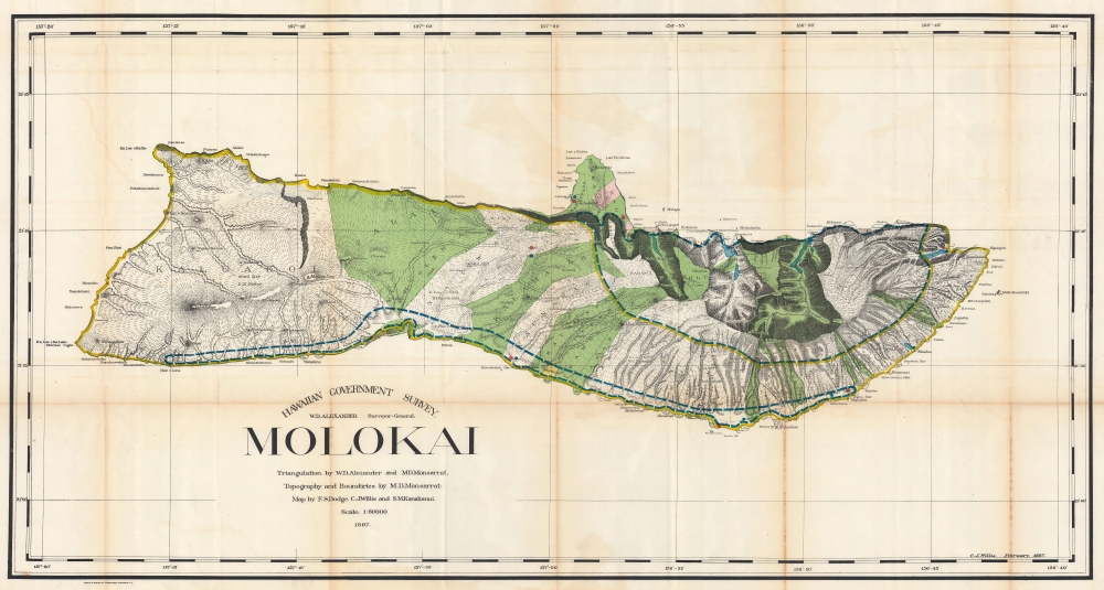
1897 Willis and Dodge Map of Molokai, Hawaiian Islands
Molokai-willis-1897$475.00


Title
Hawaiian Government Survey. Molokai.
1897 (dated) 25.5 x 48.25 in (64.77 x 122.555 cm) 1 : 60000
1897 (dated) 25.5 x 48.25 in (64.77 x 122.555 cm) 1 : 60000
Description
This 1897 Christopher Willis map of Molokai is the most sophisticated 19th century mapping of the island. Surveyors from the Hawaiian Government Survey mapped the length and breadth of Molokai and, per Moffat and Fitzpatrick, the map 'represents the final stage in the process of understanding and correctly illustrating the shape of this elongated island between O'ahu and Maui'.
A Closer Look
The map offers unprecedented detail throughout, noting types of terrain, including lava flows, topography, and a wealth of coastal features. 'Old fish ponds' are labeled along the southern coast.The Hawaiian Government Survey
The Hawaiian Government Survey was formed in 1870, when the Hawaiian Minister of the Interior, Dr. Ferdinand W. Hutchinson, asked the Legislature for $5,000 for 'Government Surveying'. Dr. Hutchinson appointed William D. Alexander surveyor general. Alexander in turn hired Curtis J. Lyons, a former surveyor and legislator, as his assistant. In 1871 they hired two assistants, J. F. Brown and J. M. Lydgate. The primary goal was to map the islands so the government could assess the territory. In addition, maps produced were available for public use. The Survey established the first sophisticated triangulation of the islands, mapped their topography, and compiled individual surveys into larger maps. Surveying began on the island of Maui, then moved to Oahu and Hawaii, then to the other islands. Work continued until 1901, when the Hawaiian Government Survey became the Hawaiian Territorial Survey and Walter E. Wall succeeded Alexander as Territorial Surveyor.Publication History and Census
This map was drawn by Christopher J. Willis, Frank S. Dodge, and Samuel Kanakanui and published in the 'Governor's Annual Report, Illustrating Conditions as of June 30, 1906'. It is well represented in institutional collections.CartographerS
Christopher James Willis (1872 - July 29, 1928) was a native Hawaiian surveyor and engineer. Born in Hawaii, Willis was the adopted son of the Right Reverend Alfred Willis, Lord Bishop of Honolulu of the Anglican church in Hawaii. He spent over forty years working for the Hawaiian Territorial Survey, followed by the Hawaiian Territorial Tax Office, and finally he served as the Assistant Engineer in the Honolulu Department of Public Works. As a teen Willis was one of Oahu's best baseball and football players and a track and field star. He died of injuries sustained after falling from a tree in his yard on Oahu. He married Emma Mossman on August 10, 1899, with whom he had one son. More by this mapmaker...
Frank S. Dodge (1855 - July 17, 1914) was an American engineer and surveyor. Educated at the Massachusetts Institute of Technology and, upon graduation, was recruited by the Hawaiian Government Survey, arriving in the islands in 1880. When he arrived, the job he had been told would be available had been filled, but William DeWitt Alexander, the founding director of the Hawaiian Government Survey, hired him to do some surveying work on Maui. Dodge did such a good job in this assignment that he earned a permanent position on the survey team. He served with the Survey until 1899, eventually rising to be head of the office staff, and surveying many of the cities in the islands. After resigning from the Survey, he became the land agent for the Bishop Estate, a position he held until four years before his death, when he suffered a stroke that caused paralysis. Dodge continued to suffer strokes over the ensuing four years, leaving Hawaii for a sanitarium outside St. Helena, California, in 1912. Dodge had been an active member of the community and supported the Honolulu library, the Social Science Club, the historical society, and other organizations. Dodge was married and had four children. Learn More...
Samuel Maikaaloa Kanakanui (November 4, 1864 - January 10, 1921) was a Hawaiian surveyor and map maker. Born in North Kohala, Hawaii, Kanakanui worked for the Hawaiian Government Survey and the Hawaiian Territorial Survey. Learn More...
William DeWitt Alexander (1833 - 1913) was a Hawaiian born historian, publisher, writer, surveyor, and teacher. Alexander was born in Honolulu in 1833 to missionary parents. He received a degree from Yale University in 1855. After completing his studies, Alexander remained in the continental United States, first, during the winter of 1855 - 56, taking a job at Beloit College in Wisconsin. Then he moved on to become the schoolmaster of the Vincennes Academy in Vincennes, Indiana, a school recently started by one of his uncles. He returned to Hawaii in 1858 after receiving an offer to teach at the Punahou School, where he taught Greek and history. He became president of the school (then known as O'ahu College) in November 1864. During this time Alexander published a number of books on Hawaiian history and ethnography. In 1869, during a summer vacation, Alexander undertook a survey and produced a map of the Haleakala Crater on Maui. Although he had spent the previous fourteen years in education, he came by his surveying skills honestly. His father, William Patterson Alexander, was a surveyor, and 'W. D.' (as Alexander was known during his childhood) would likely help his father when on vacation from attending the Punahou School. Alexander's map of Haleakala was likely the most scientific land survey of Hawaii produced up to that time. With this achievement, Alexander was appointed surveyor general of the Hawaiian Government Survey in the fall of 1870. This appointment handed Alexander the task of creating a surveying and mapping agency for the Hawaiian government. In this office Alexander did much of his most important work in mapping the Hawaiian Islands. He remained the Surveyor-General of the Hawaiian Government Survey until American annexation of the Hawaiian Islands in 1898, and even then, because the transition took place over a few years, he held the position until 1901. Eventually he attained the office of Surveyor-General of the Territory of Hawaii and a high position in the Privy Council of Kalakaua and Lili'uokalani. Alexander resigned as the head of the Hawaiian Territorial Survey in 1901 when he was put in charge of the Branch Office of the U.S. Coast and Geodetic Survey in the Hawaiian Islands. Alexander married Abigail Charlotte Baldwin in 1860 with whom he had three sons and two daughters. Learn More...
Andrew B. Graham (1845 - September 9, 1909) was an American lithographer active in Washington, D.C. in late 19th and early 20th century. Graham was born in Washington D.C., the son of a lithographer and engraver. After college, he joined the U.S. Coast Survey, where he was a draftsman until 1889. He retired from the Coast Survey to take over management of his father's lithography firm. The firm, Andrew B. Graham Company, was one of several that thrived on lucrative government publication contracts. Graham died of 'brain fever' in his Washington D. C. residence on September 9 of 1909. Some of his work was republished posthumously until about 1917, and his firm was active until at least the early 1920s. Learn More...
Source
Governor of Hawaii Board of Indian Commissioners, 'Report of the Governor of Hawaii', Annual Reports of the Department of the Interior for the Fiscal Year Ended June 30, 1906, (Washington: Government Printing Office) 1907.
Condition
Good. Wear, toning, and soiling along original fold lines. Verso repairs at fold intersections. Some offsetting.
References
Moffat, R. M. and G. L. Fitzpatrick, Mapping the Lands and Waters of Hawaii (Honolulu: Editions Limited) 2004. p. 43. OCLC 958373244.