This item has been sold, but you can get on the Waitlist to be notified if another example becomes available, or purchase a digital scan.
1850 Gibbs Map of Jaffrey and Mount Monadnok, New Hampshire
MonadnokJaffreyNH-gibbs-1850$1,000.00


Title
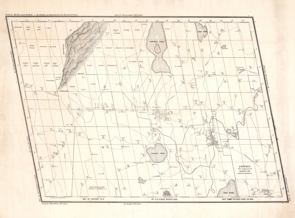
Map of Jaffrey N.H. by J. D. Gibbs, March 1850.
1850 (dated) 28.5 x 38.5 in (72.39 x 97.79 cm) 1 : 14080
1850 (dated) 28.5 x 38.5 in (72.39 x 97.79 cm) 1 : 14080
Description
This is the 1850 Jonathan Danforth Gibbs large-scale map of Jaffrey, New Hampshire, considered the first separately issued map of that region. Mount Monadnock, one of the highest points in southern New Hampshire and at the time the stomping ground of the transcendentalists, appears prominently yet idiosyncratically illustrated in the upper left.
The First Separate Map of Jaffrey
According to Jaffrey historians R. B. Stephens and C. L. Seiberling, who have studied the map in the local context,His map clearly shows just how much the town had grown since Carrigain’s map of 34 years earlier. East Jaffrey is depicted here as a larger settlement than the Center, when not long before it was not much more than a river crossing and mill site. Note the churches (Congregational, Baptist and Universalist), School House No. 2 (now a residence at 59 School Street), the Bank (32 Main Street) and Jonas Melville’s grand stone house (now St. Patrick convent). The layout and size of the Center is not too different from today. The Meetinghouse, Melville Academy, the Brick Church and most of the other structures are recognizable. Among those that no longer exist are Cutter’s Hotel (shown on the Upper Common), the Armory across from The Manse (which was moved to 33 North Street), the blacksmith shop (labelled W. Lacy) and Schoolhouse No. 7. At the south end of the pond at the eastern edge of the village is shown the Cutter tannery, the stone and brick foundations of which can still be seen. The house of the map’s creator is next to the schoolhouse. (Stephenson, R. B., and Seiberling, C. L., Jaffrey Then and Now, page 99, illus. 6-2a and b)
A Hobbyist Cartographer
This map is unusual in that the maker, Gibbs, was neither a surveyor nor a printer - instead, he was a popular local cobbler. Gibbs settled in Jaffrey in 1821 and in his spare time, delved into local history. He taught himself surveying and proceeded to map the surrounding territory. Although seemingly primitive, the buildings depicted here are accurate and many remain recognizable today. Gibbs' own home appears dead center on Turnpike Road (385 Main Street, Jaffrey Center).Publication History and Census
This map was drawn and compiled by Jonathan Danforth Gibbs. It was published in Boston by Benjamin W. Thayer and Company. We have identified no confirmed example of this map in any institutional collection, but believe there may be an example in the Jaffrey Historical Society.CartographerS
Jonathan Danforth Gibbs (May 24, 1796 - March 2, 1882) was a New Hampshire cobbler, as well as an amateur historian and surveyor active in Jaffrey in the mid-19th century. He was born in Ashburnham, Massachusetts, but settled in Jaffrey in 1821. Achieving some success as a cobbler, he built a two-story home in Jaffrey Center, which still stands as 385 Main Street. His leisure time was dedicated to studying local history and geography. In 1850 he drafted and published a large-scale map of Jaffrey, considered the first separate specific map of that town. Gibbs died in Jaffrey in 1882. More by this mapmaker...
Benjamin W. Thayer (1814 - December 17, 1875) was a Boston based lithographer, newspaper investor, and real-estate broker active in the middle part of the 19th century. Thayer published as 'B. W. Thayer and Company.' He appears to have had two periods of activity, between 1840 and 1847 and between 1851 and 1853. In 1840 he took over the shop of William S. Pendleton and Moore, which he rand with his brother-in-law, John H. Bufford, and John E. Moody. He abandoned the partnership in 1846, establishing himself at 208 Washington Street as a 'fancy goods seller' and lithographer. He does not appear in the Boston Directory between 1848 and 1850, suggesting he was no longer active. He reestablished his partnership with Bufford in 1851 and appears again in the Directory until 1853, when he sold the shop to S. W. Chandler. He leveraged the assets of the sale to become a wealthy newspaper investor and real estate agent. Learn More...
Condition
Very good. Closed tear lower left margin, not impacting image.
References
Stephenson, R. B., and Seiberling, C. L., Jaffrey Then and Now, page 99, illus. 6-2a and b.