1894 Rockhill Map of China, Tibet, and Mongolia
MongoliaTibet-rockhill-1894$650.00

Title
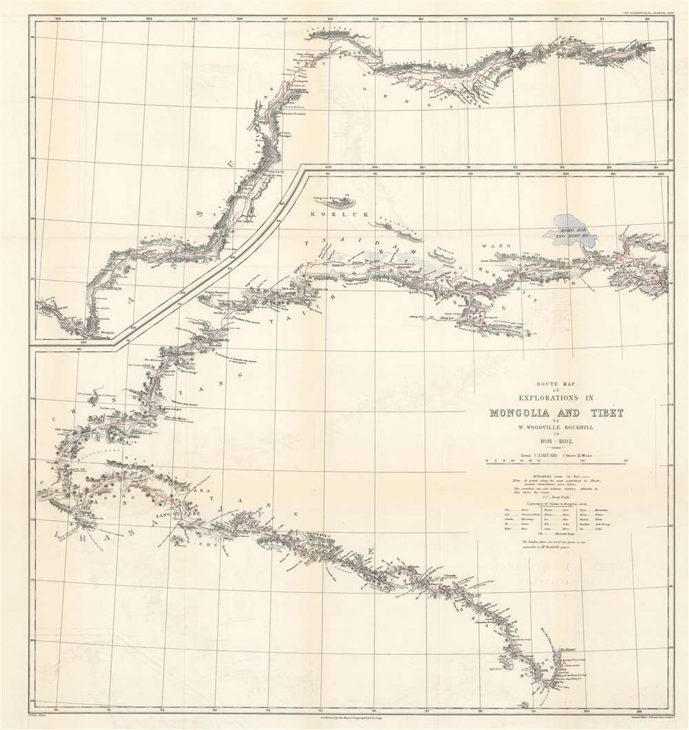
Route Map of Explorations in Mongolia and Tibet by W. Woodville Rockhill in 1891 - 1892.
1894 (dated) 26 x 24 in (66.04 x 60.96 cm) 1 : 2027520
1894 (dated) 26 x 24 in (66.04 x 60.96 cm) 1 : 2027520
Description
This is an important 1894 William Woodville Rockhill 'Great Game' map of western China, eastern Tibet, and part of Mongolia. The map depicts from Zhangjiakou, China to Xikangbatang, China and follows Rockhill's route in his attempt to reach Lhasa, Tibet.
Remarkable Detail
Providing a surprising amount of detail along the route, Rockhill covered 'about 8,000 miles' and 'surveyed 3,417'. He 'crossed sixty-nine passes,' all of which exceeded 14,500 feet. Along his route he took sextant observations, calculated distances by counting his steps, and recorded atmospheric pressure, temperature, and weather conditions three times daily. He also made triangulation measurements as often as possible, although he wanted to be discreet with his measurements at all times. 'At each camp the altitude was determined by boiling-point of water'. His expedition lasted eleven months, from the day he set out from Shanghai until the day he returned.A Closer Look
Rockhill's map detailed his route from Zhangjiakou to Xikangbatang, highlighted in red. Zhangjiakou is situated in the upper right with Xikangbatang on the lower right. Rockhill marks missionary stations, and provides commentary on land use, noting where land is cultivated, along with hills, ditches, and brush. An explanation of Tibetan and Mongolian words employed is situated below the title cartouche, as is a note stating that the altitudes provided on the map are relative to the feet above the route.Significance of Rockhill's Map
In the late 19th century, when Rockhill was making his expeditions into Mongolia and Tibet, Tibet was a isolated from foreigners. All the Great Powers, particularly Russia and the British Empire, had designs on Central Asia, and were suspicious of each other's intent. Part of 'The Great Game', these suspicions led to a British invasion of Tibet in 1904 with the hope it would foster good relations with the Dalai Lama and preempt a Chinese incursion.Publication History and Census
This map was created by William Woodville Rockhill and published in Volume III Issue No. 5 of The Geographical Journal. This edition is a reduction of a larger map published by the Smithsonian Institution that same year. This map is very rare, with only one example, at the British Library, cataloged in the OCLC.CartographerS
William Woodville Rockhill (May 1, 1854 - December 8, 1914) was an American diplomat, the first American to learn to speak Tibetan, and the author of the American Open Door Policy towards China. Born in Philadelphia, Rockhill's father died when he was ten months old leaving behind a wife and two young sons. His mother, Dorothea, came from a wealthy Baltimore family, and when William was eleven she moved the family to Paris, and installed them in a small apartment close to the Place Pereire. Rockhill soon gained admission to the École spéciale militaries de Saint-Cyr, the French West Point, with the help of the American minister in Paris. It was here that Rockhill discovered the work of Abbé Huc which described his travels in China and Tibet. Rockhill developed a deep fascination for the subject, and after some inquiries, found himself a tutor in Tibetan at the Bibliothèque Nationale. After graduation from Saint-Cyr, Rockhill served for three years as a second lieutenant in the French Foreign Legion in Oman before resigning his commission and returning to the United States to court a young woman, Caroline Tyson. Caroline and William married on December 14, 1876, and soon the couple bought a cattle ranch in New Mexico with Caroline's uncle. The couple spent four years ranching Texas longhorns, and Rockhill used to devoted much of his time to studying Tibetan, Chinese, and Sanskrit. Eventually, after four hard years and no real wealth amassed, the ranch was sold and Rockhill and Caroline moved their family to Montreux, Switzerland, where his mother and her Swiss husband lived. Here Rockhill devoted his time to translating the Undânvarga, a Tibetan work of Indian moral maxims, and two other sacred Tibetan texts. In 1884, Caroline Rockhill unexpectedly inherited $70,000 from a cousin, a fortune with which her husband could finally afford his long-desired trip to China. With this trip came an appointment as an unpaid member of the staff of the American Legation in Peking, which soon became a paid position. During his time in China, Rockhill undertook two extended trips into western China, Mongolia, and Tibet. After serving for nearly a decade in China, Rockhill was named Third Assistant Secretary of State in April 1894, and soon began climbing the ranks in the State Department, serving as the U.S. Minister to Greece from 1897 - 1899, as well as Minister to Serbia and Minister to Romania. After the outbreak of the Boxer Rebellion, Secretary of State John Hay turned to Rockhill for advice, and Rockhill's response was the now famous Open Door Policy towards China. Rockhill was named Minister to China by Theodore Roosevelt and serving from June 17, 1905 until June 1, 190. He then served as Minister to Russia from January 11, 1910 until June 17, 1911. Rockhill was named Advisor to the President of China in 1914, and, after leaving San Francisco on his way to take up the position, developed pleurisy and had to disembark at Honolulu for treatment. Here, after recovering from the pleurisy, Rockhill suffered heart failure and died on December 8, 1914. More by this mapmaker...
Royal Geographical Society (fl. 1830 - present) is a British Society established in 1830 to promote geographical science and exploration. Originally titled the "Geographical Society of London", the RGS received its royal charter from Queen Victoria in 1859 shortly after absorbing several similar but more regional societies including the African Association, the Raleigh Club and the Palestine Association. The RGS sponsored many of the most important and exciting voyages of exploration ever undertaken, including the exploration of Charles Darwin, David Livingstone, Robert Falcon Scott, Richard F. Burton, John Speke, George Hayward, H. M Stanley, Ernest Shackleton and Sir Edmond Hillary. Today, the RGS remains a leading global sponsor of geographical and scientific studies. The Society is based in Lowther Lodge, South Kensington, London. Learn More...
Source
Rockhill, W.W., 'A Journey in Mongolia and Tibet', The Geographical Journal (London: Royal Geographical Society) Vol. III, No. 5, May 1894.
Condition
Very good. Light toning along original fold lines. Light transference.
References
OCLC 557688637.