This item has been sold, but you can get on the Waitlist to be notified if another example becomes available, or purchase a digital scan.
1961 U.S.G.S. Glacial Map of Montana, East of the Rocky Mountains
MontanaRocky-usgs-1961$200.00

Title
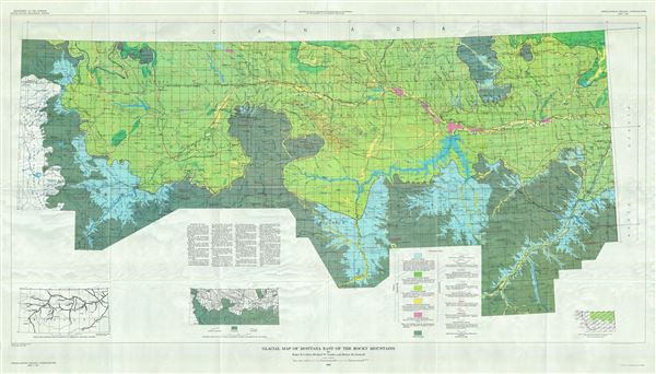
Glacial Map of Montana East if the Rocky Mountains.
1961 (dated) 33 x 59 in (83.82 x 149.86 cm) 1 : 500000
1961 (dated) 33 x 59 in (83.82 x 149.86 cm) 1 : 500000
Description
This is a beautiful 1961 map of Montana by the U.S. Geological Survey. It covers Montana east of the Rocky Mountains, from Lewis and Clark National Forest east as far as Richland and the Montana state boundary. The map is highly detailed and notes lakes, creeks, rivers, lakes, towns, and a host of other topographical features. Color coded to indicate glacial lake deposits, moraine deposits, ice-contact stratified drift deposits, outwash, inwash and terrace deposits and unglaciated areas, it also marks glacial advances, boulder train, etc. Three inset maps are included along the bottom margin including a sketch map showing major segments of preglacial drainage courses and glacial movement during successive ice advances. Includes a key in the bottom margin.
This map was based on the earlier U.S.G.S. Montana state map of 1923 and was prepared by Roger B. Colton, Richard W. Lemke and Robert M. Lindvall for the U.S. Geological Survey's Miscellaneous Geologic Investigations as map I-327.
This map was based on the earlier U.S.G.S. Montana state map of 1923 and was prepared by Roger B. Colton, Richard W. Lemke and Robert M. Lindvall for the U.S. Geological Survey's Miscellaneous Geologic Investigations as map I-327.
Cartographer
The United States Geological Survey (1878 - Present), aka the U.S.G.S., is a scientific agency of the United States government, which was founded in 1879. USGS scientists study the landscape of the United States, its natural resources, and the natural hazards that threaten it. The organization has four major science disciplines: biology, geography, geology, and hydrology. It is a bureau of the United States Department of the Interior and is the department's only scientific agency. More by this mapmaker...
Source
Miscellaneous Geologic Investigations. Department of the Interior. U.S. Geological Survey.
Condition
Very good. Minor wear along original fold lines.