This item has been sold, but you can get on the Waitlist to be notified if another example becomes available, or purchase a digital scan.
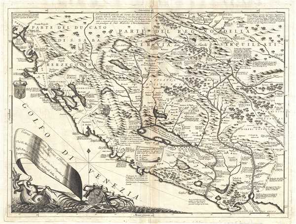
1690 Coronelli Map of Montenegro
Montenegro2-coronelli-1690$500.00

Title
Corso delli Fiumi Drino, e Boiana nella Dalmatia, descrito dal P. Mro Coronelli Cosmografo della Seren. Republica di Venezia dedicato - Agli Em; e Reu; Signori Cardinali della Sacra congregatione de Propaganda Fide.
1690 (undated) 17.5 x 24 in (44.45 x 60.96 cm) 1 : 310000
1690 (undated) 17.5 x 24 in (44.45 x 60.96 cm) 1 : 310000
Description
This is Vincenzo Maria Coronelli's 1690 map of Montenegro. The map covers the Dalmatian coast from Dubrovnik to Gjiri i Drinit, including all of modern day Montenegro as well as parts of adjacent Croatia, Albania, and Bosnia Herzegovina. Most of Coronelli's maps of the Dalmatian coast were intended to highlight the military victories of the Venetian Republic over the expansive Ottoman Turks. No exception, this map features notations throughout referring to various military battles for control of this hotly contested region.
This map was created at the height of the Morean War, better-known as the Sixth Ottoman-Venetian War, which lasted from 1684-1699. Venice became a member of the Holy League, which consisted of the Habsburg Empire (Austria-Hungary), Poland, Russia, and Venice. This alliance was organized by Pope Innocent Xi to oppose the expansionist tendencies of the Ottoman Empire, following their attempted capture of Vienna in 1683. Upon joining the Holy League, Venice declared war on the Ottoman Empire, the first and only time that happened. Most of the fighting involving Venetian troops took place in Greece, with the Venetian goal of recapturing Crete and other territory previously lost to the Ottomans. Fighting in Dalmatia was intense. Several different cities were besieged, some multiple times. Much of the final border between Dalmatia and Bosnia and Herzegovina was determined by the end of the successful Venetian campaign.
As a whole this is a splendid example of Coronelli's distinctive style at its finest. The map features detailed engraving, historical notes, armorial vignettes, and an elaborate title cartouche complete with a cherub riding a sea monster with the title scrolled on the sail. The map was published for inclusion in Coronelli's stupendous 1690 Atlante Veneto.
Cartographer
Vincenzo Maria Coronelli (August 16, 1650 - December 9, 1718) was an important 17th-century cartographer and globe maker based in Venice. Coronelli was born the fifth child of a Venetian tailor. Unlikely to inherit his father's business, he instead apprenticed in Ravenna to a woodcut artist. Around 1663, Coronelli joined the Franciscan Order and, in 1671, entered the Venetian convent of Saint Maria Gloriosa dei Frari. Coronelli excelled in the fields of cosmography, mathematics, and geography. Although his works include the phenomenal Atlante Veneto and Corso Geografico, Coronelli is best known for his globes. In 1678, Coronelli was commissioned to make his first major globes by Ranuccio II Farnese, Duke of Parma. Each superbly engraved globe was five feet in diameter. Louis IV of France, having heard of the magnificent Parma globes, invited Coronelli to Paris, where from 1681-83 he constructed an even more impressive pair of globes measuring over 12 feet in diameter and weighing 2 tons each. The globes earned him the patronage of Louis XIV and privileged access to French cartographic information from Jesuit sources in the New World, particularly Louisiana. Coronelli returned to Venice and continued to publish globes, maps, and atlases, which were admired all over Europe for their beauty, accuracy, and detail. He had a particular fascination for the Great Lakes region, and his early maps of this area were unsurpassed in accuracy for nearly 100 years after their initial publication. He is also well known for his groundbreaking publication of the first accurate map depicting the sources of the Blue Nile. At the height of his career, Coronelli founded the world's first geographical society, the Accademia Cosmografica degli Argonauti, and was awarded the official title Cosmographer of the Republic of Venice. In 1699, in recognition of his extraordinary accomplishment and scholarship, Coronelli was also appointed Father General of the Franciscan Order. The great cartographer and globe maker died in Venice at the age of 68. His extraordinary globes can be seen today at the Bibliothèque Nationale François Mitterrand in Paris, Biblioteca Marciana in Venice, the National Library of Austria, the Globe Museum in Vienna, the Library of Stift Melk, the Special Collections Library of Texas Tech University, as well as lesser works in Trier, Prague, London, and Washington D.C. Coronelli's work is notable for its distinctive style, which is characterized by the high-quality white paper, dark intense impressions, detailed renderings of topographical features in profile, and numerous cartographic innovations. More by this mapmaker...
Source
Coronelli, V., Atlante Veneto, (Venice: Girolamo Albrizzi) 1697.
The Atlante Veneto was a Venetian cosmographic atlas issued by the Jesuit Minorite friar, geographer, and globe maker Vincenzo Maria Coronelli. The massive work consists of some 13 volumes in four parts. The first section focused on a general introduction to geography and included notes on various geographic systems and globes. The second part consisted of world maps from various periods and in various styles, including double-page maps of the continents and poles derived from his earlier globe work. The third part focused on hydrography and included nautically styled maps of important rivers, bays, oceans, lakes, and gulfs. The fourth and final section details exploration. The whole consisted of some 191 engraved charts and maps as well as an assortment of views and decorative plates. The atlas was conceived as a continuation of Blaeu's Atlas Major and, in many respects, follows Blaeu cartographically. Many of the other maps are derived from Coronelli's own earlier globe work and exhibit distinctly globe-like elements. Coronelli first issued the Atlante Veneto in 1691. A second edition was prepared and issued between 1695 and 1697. Most of the individual map plates remain identical and thus indistinguishable between editions. The maps of the Atlante Veneto are universally admired for their exquisite engraving and high production quality, including fine paper and premium inks. All examples were issued uncolored and have typically been left as such by dealers and collectors. Some of Coronelli's other works, including the Isolario dell' Atlante Veneto, Libro dei Globi, and Corso Geografico Universal, might reasonably considered amendments and expansions on the Atlante Veneto.
Condition
Very good. Wear along original centerfold. Minor verso repair of fold separation. Blank on verso. Original press mark visible.
References
Bibliothèque Nationale de France, Collection d'Anville ; 06012. OCLC 837640145.