This item has been sold, but you can get on the Waitlist to be notified if another example becomes available, or purchase a digital scan.
1950 Ruth Taylor Pictorial Map of Monterey Bay, California
MontereyBay-whiteruthtaylor-1950$200.00

Title
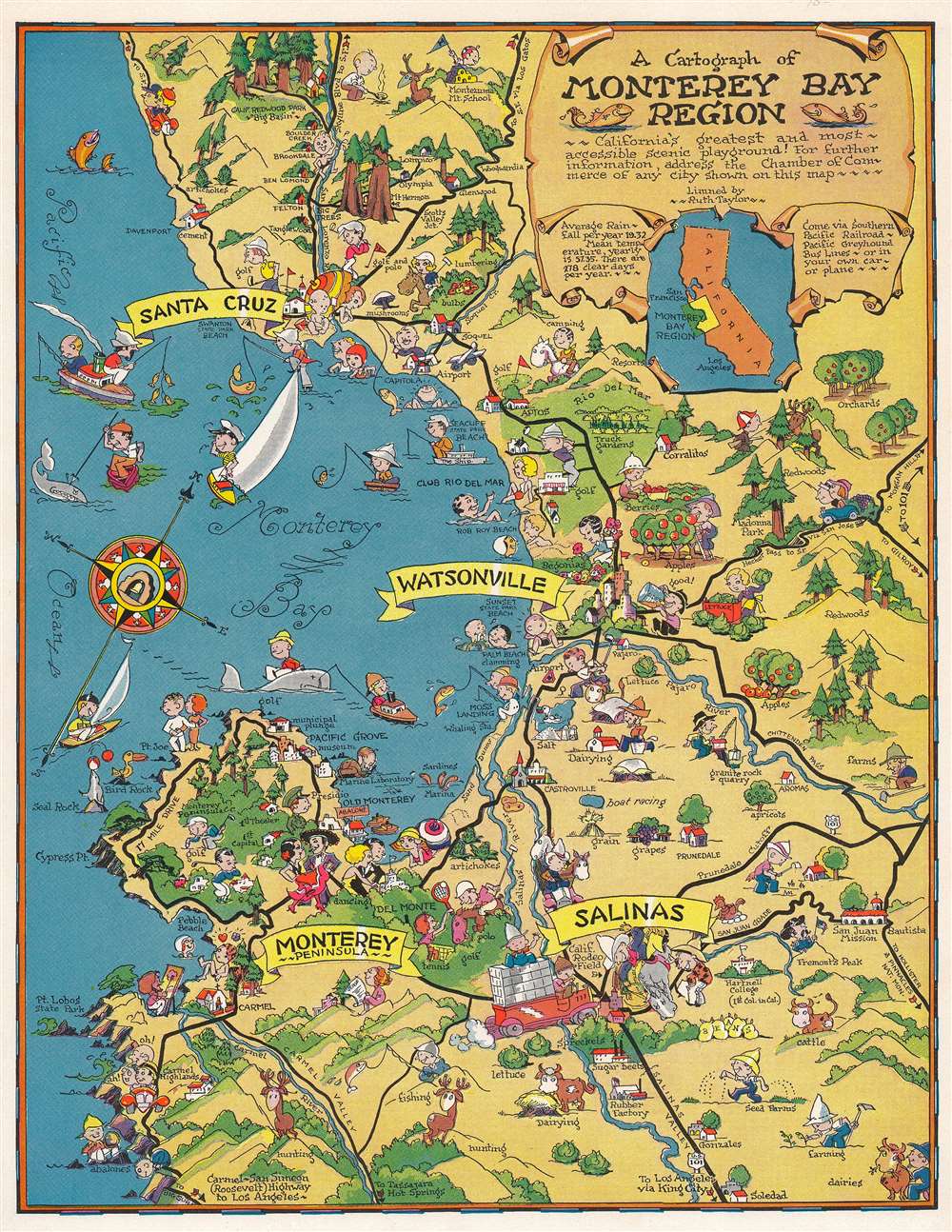
A cartograph of Monterey Bay region.
1950 (undated) 10.25 x 8 in (26.035 x 20.32 cm) 1 : 300000
1950 (undated) 10.25 x 8 in (26.035 x 20.32 cm) 1 : 300000
Description
This is a c. 1950 pictorial map or 'cartograph' by Ruth Taylor depicting the Monterey Bay and surrounding communities along the California central coast. The richness and variety of the region's economy and culture are illustrated, ranging from maritime activities to golfing, hunting, and rodeos.
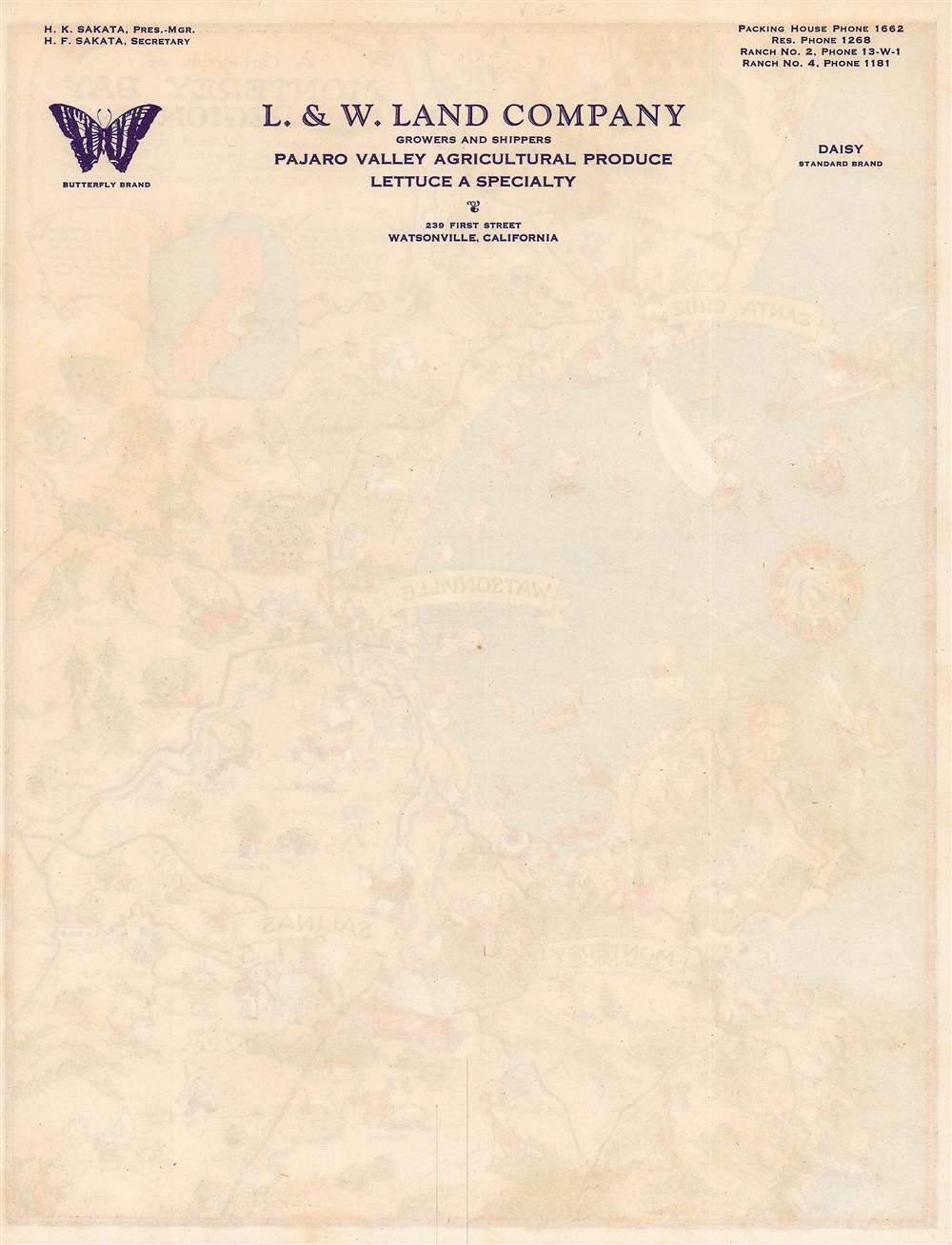
The coastal-inland dichotomy of the region is apparent here, with agriculture dominating in the Salinas and Pajaro Valleys. The verso includes a letterhead for the L. and W. Land Company, a produce supplier, based in Watsonville. It is noteworthy that the leadership of this company appears to have had Japanese surnames. During the Second World War, the California Rodeo Field (also known as the Salinas Rodeo Grounds) was used as a temporary detention facility for Japanese-Americans from the Monterey Bay region (many of whom were farmers), after which they were relocated to other facilities further inland, generally the Poston War Relocation Center in Yuma County, Arizona.
A Closer Look
This map highlights the range of industries, leisure activities, and tourist attractions in the Monterey Bay region, one of the most scenic in California. The natural beauty of the region has attracted a succession of schemes to develop tourism and draw wealth. In the late 19th century, many of these schemes were housed under Pacific Improvement, an umbrella company founded by the 'Big Four' businessmen and railroad tycoons behind the Central Pacific Railroad (that is, the western portion of the first Transcontinental Railroad). Among their projects were the opulent Del Monte Hotel in Monterey and 17-Mile Drive. Artists flocked to the area and golf courses blossomed, including the world-famous Pebble Beach Golf Links.The coastal-inland dichotomy of the region is apparent here, with agriculture dominating in the Salinas and Pajaro Valleys. The verso includes a letterhead for the L. and W. Land Company, a produce supplier, based in Watsonville. It is noteworthy that the leadership of this company appears to have had Japanese surnames. During the Second World War, the California Rodeo Field (also known as the Salinas Rodeo Grounds) was used as a temporary detention facility for Japanese-Americans from the Monterey Bay region (many of whom were farmers), after which they were relocated to other facilities further inland, generally the Poston War Relocation Center in Yuma County, Arizona.
Publication History and Census
This pictorial map was 'limned' (drawn) by Ruth Taylor. In the OCLC, it is cataloged as being published by the Chamber of Commerce of the Pajaro Valley, a plausible estimation given the text in the cartouche, though there is no mention of that specific organization on this example. Instead, the verso includes a letterhead for the L. and W. Land Company, based in Watsonville. This cartograph is known to be held by five institutions as well as the David Rumsey Historical Map Collection, which alternatively dates it to 1932 and suggests that it was distributed by the Southern Pacific Railroad. However, references here (such as the San Simeon or Roosevelt Highway, Point Lobos State Park, and Swanton State Park Beach) would suggest a date of the late 1930s or later. This map is scarce to the market.Cartographer
Ruth D. Taylor White (March 1896 - 20??), a.k.a. Ruth Taylor Day, was an American pictorial mapmaker, what she liked to call 'carto-graphy'. Ruth was born Oregon to the painter John S. Taylor (1858 - 1927). Her interest in cartographic mapmaking was probably inspired by her sister Della Taylor Hoss (1900 - 1997), also an important pictorial cartographer. One of her first published works was a cover of The Stanford Illustrated Review, where her brother Frank attended university. Frank was an accomplished journalist and writer, and Ruth provided the illustrations for two of his books, popular works about the national parks, ’Oh Ranger!’ A Book About the National Parks and Grand Canyon Country. In the spring of 1930, White traveled to Hawaii, where she received a commission from the Hawaii Tourist Bureau to create pictorial maps of the Hawaiian Islands. Sets of five maps began appearing in 1931, with maps of Kauai, Oahu, Maui, Hawaii, and the island chain as part of the set. These were most likely handed out to visitors by the Bureau. White’s most famous work, a pictorial atlas entitled, Our USA: A Gay Geography was published in 1935 and was filled with ‘cartography’ of each state, which she published with her brother as Ruth Taylor. White is also known for her map of Treasure Island, the site of the Golden Gate International Exposition. A third sister, Bernice Taylor Fitzgerald, was also an artist, but did not make maps. Ruth was still an active artist as late as 1997. There is no record of her death, suggesting she may well be a centenarian. More by this mapmaker...
Condition
Very good.
References
Rumsey 6775.000. OCLC 25280513.