This item has been sold, but you can get on the Waitlist to be notified if another example becomes available, or purchase a digital scan.
1565 Ramusio Map of Hochelaga (first printed depiction of a North American Settlement)
Montreal-ramusio-1565$2,250.00

Title
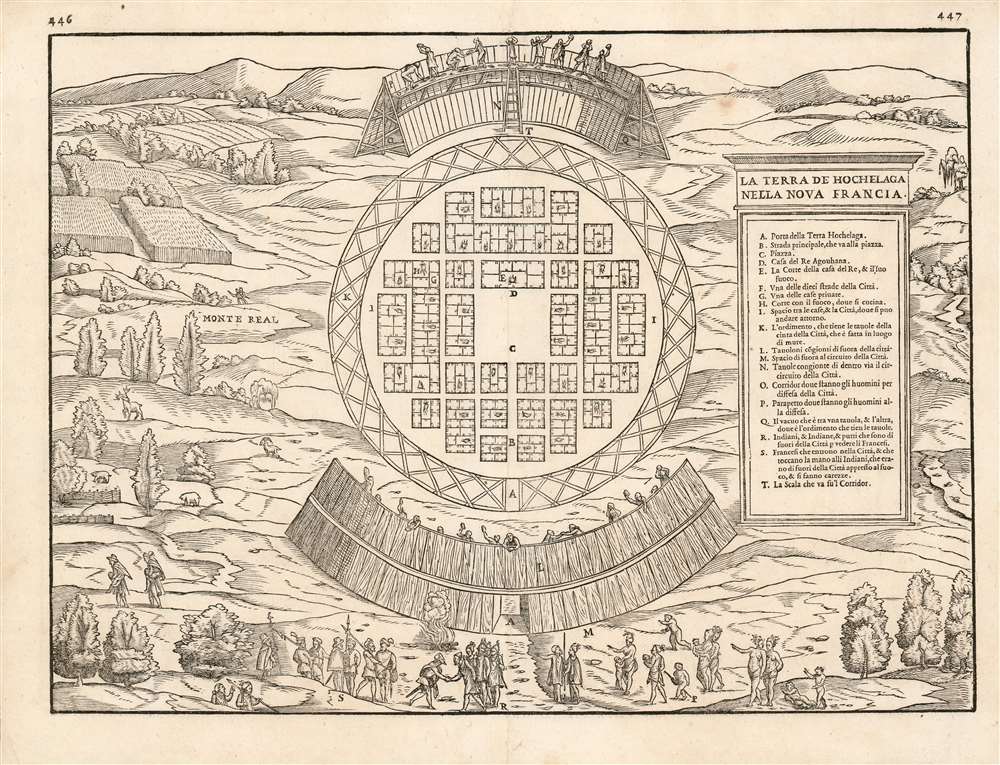
La Terra de Hochelaga Nella Nova Francia
1565 (undated) 10.5 x 14.5 in (26.67 x 36.83 cm)
1565 (undated) 10.5 x 14.5 in (26.67 x 36.83 cm)
Description
This is an attractive example of the scarce first map of 'Montreal.' Printed in 1565, it is what Schwartz calls 'The very first plan of a village in the United States or Canada,' and it is the earliest printed map to use the place name 'Monte Real,' which would become Montreal. Perhaps even more significantly, this woodcut is one of the only images from the Discovery Period of an intact indigenous town, and its customs.
A Friendly Meeting
In a scene that suggests a more promising start to European/ Native American relations than perhaps would prove to be warranted, Cartier is shown at lower center being greeted with evidence friendliness by the St. Lawrence Iroquoian chief, or 'Agouhanna'. (Though the map's text suggests that this was the Iroquoian king's name, such was not the case. Cartier's Bref Recit Et Succincte Narration de la Navigation more correctly named the man: '...le seigneur de Canada nomé Donnacona en nom, et l'appelent pour seigneur Agouhanna...' translating to: 'the chief of Canada, called Donnacon by name, and called Agouhanna for chief.') The peacefulness of the scene is emphasized by the presence of a crowd of women and children who have ventured outside the city to see the French.A Glimpse of Iroquois Life
In providing the first European visual depiction of a Native American town, this woodcut also provides some of the only documentation of St. Lawrence Iroquois life. Certainly, we are presented with a society organized for its own defense: central to the view are a detailed depiction of the town's wooden stockade, replete with a parapet and gangway for defenders. The town itself is represented as orderly, with streets and a central square; a house for the king and his father faces on to the square. The plan indicates the presence, also, of private homes, each with its own cooking hearth - some shown to be separate, some connected to each other, none significantly less grand than that of the King himself. Outside the stockade are shown fields under cultivation, and areas fenced in for the control of game. In the lower left, we see two adults being carried piggyback: Cartier refers to this as a Hochelagan gesture of respect - following their visit, Cartier and his companions were carried back to their boats by their hosts. The Agouhanna himself had been brought from the city to the French on the shoulders of nine or ten men. The social order implied in the view suggested that the Iroquois might be a people with whom the French could profitably interact, while the freedom apparently exhibited among the native's women would have told a 16th century European that here was a people who would benefit from the strictures of Christianity.Publication History and Census
This map was first engraved by Matteo Pagano for inclusion in the third volume of Ramusio's Navigationi et Viaggi in 1556. The woodblocks for this, and indeed all of the maps of the 1556 edition burned in a warehouse fire in 1557. It appears in only one known state. The blocks were all re-engraved, probably again by Pagano, for the 1565 edition of the Navigationi et Viaggi. This second block is geographically identical to the first, but there are distinguishable changes; the two blocks are most easily differentiated by the addition of a willow tree on the new version at the upper right, as well as the opacity of the smoke from the fire by the entrance of the stockade. Also, the letter 'F' corresponding to the map's key is missing on this second block. This block was employed one more time in 1606, this edition easily identifiable by the small worm-shaped blank areas visible on the map (woodworm appears to have similarly infested all blocks of the 1606 edition.) The 1556 edition of the third volume of Navigationi et Viaggi. is rare. Seven examples of the 1565 are listed in OCLC, while perhaps twenty of the 1606 edition appear in institutional collections. The 1565 edition of the separate map appears only at the Library and Archive of Canada; only five other examples of the other editions appear in OCLC.CartographerS
Giovanni Battista Ramusio (July 20, 1485 - July 10, 1557) was an Italian civil servant, humanist, scholar, historian, and geographer active in the middle part of the 16th century. Ramusio spent most of his life in the service of the Republic of Venice, first as part of that state's embassy to France, and later as a reporter on voyages and discoveries. He was born to an illustrious family in Treviso and moved to Vencie as a young man, where his father was a magistrate. He studied at the University of Padua but may not have received a full degree. He entered the civil service shortly after leaving the university and was immediately assigned to diplomatic service for his facility with languages, particularly French. His most significant contribution to cartography is his publication of Navigationi et Viaggi a collection of travel narratives he collected in his service to the state. The narratives include those of Marco Polo, Niccolò Da Conti, Magellan, Alvar Nuñez Cabeza de Vaca, Giosafat Barbaro, and Tomé Pires, among others. Some of the voyages appearing in the Navigationi et Viaggi are otherwise unknown, marking it as an exceptionally important volume. Ramusio died in Venice in 1557. More by this mapmaker...
Giacomo Gastaldi (c. 1500 - October, 1566) was an Italian astronomer, cartographer, and engineer active in the second half of the 16th century. Gastaldi (sometimes referred to as Jacopo or Iacobo) began his career as an engineer, serving the Venetian Republic in that capacity until the fourth decade of the sixteenth century. During this time he traveled extensively, building a large library relating to voyages and exploration. From about 1544 he turned his attention to mapmaking, working extensively with Gextantiovanni Battista Ramusio, Nicolo Bascarini, and Giovanbattista Pedrezano, as well as taking private commissions for, among others, Venice's Council of Ten. He is credited with the fresco maps of Asia and Africa still extant in the map room of the Doge's Palace. Gastaldi was also one of the first cartographers to embrace copper plate over woodblock engraving, marking an important development in the history of cartography. His 1548 edition of Ptolemy's Geographia was the first to be printed in a vernacular; it was the first to be printed in copperplate. As with his Swiss/German contemporary Münster, Gastaldi's work contained many maps depicting newly discovered regions for the first time, including the first map to focus on the East Coast of North America, and the first modern map of the Indian Peninsula. His works provided the source for the vast majority of the Venetian and Roman map publishers of the 1560s and 70s, and would continue to provide an outsize influence on the early maps of Ortelius, De Jode, and Mercator. Learn More...
Matteo Pagano (1515-1588) was a Venetian woodcut artist and illustrator. While nothing is known about his early training, he was prolific and apparently successful. Among his more famous works is a 1556 eight-sheet woodcut of the procession of the Doge, in Venice. He produced a number of maps for various works, most notably the visually distinctive area maps appearing in Ramusio's Navigazioni et Viaggi. He is particularly noted for having published books of lace, needlework and embroidery designs, promoting needlework as an acceptable activity for virtuous women. Learn More...
Source
Ramusio, G. B., Navigationi et Viaggi, Vol 3, (Venice) 1565.
Condition
Very good condition. Two wormholes near upper margin invisibly repaired, marginal mend at upper centerfold. Else excellent with a bold, sharp strike.
References
OCLC 1007207286. Kershaw, K. Early Printed Maps of Canada, Vol 1 entry 17a.