This item has been sold, but you can get on the Waitlist to be notified if another example becomes available, or purchase a digital scan.
1967 USGS Geologic Map of the Moon: Copernicus Crater Quadrangle
MoonCopernicus-usgs-1967$200.00

Title
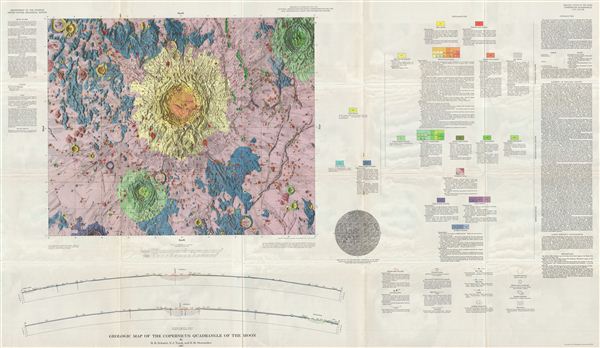
Geologic Map of the Copernicus Quadrangle of the Moon by H. H. Schmitt, N. J. Trask, and E.M. Shoemaker.
1967 (dated) 31 x 53.5 in (78.74 x 135.89 cm)
1967 (dated) 31 x 53.5 in (78.74 x 135.89 cm)
Description
A stunning full color geologic map of the Copernicus Quadrangle of the Moon from 1967, by the U.S. Geological Survey. Includes two sectional views (from the side) of the area, detailed text on the formation of the area's geology, extremely detailed ‘metadata' explaining the mapmaking methodologies and symbols employed, and an index map showing the location of this quadrangle on the Moon.
This map represents a breath-taking leap forward not only in selenography (the study of the moon), begun in the late 1400s, but also in the record of humankind's fearless exploration of the world(s) around and beyond us.
The map's feature names highlight this lineage: Copernicus, whose sun- or ‘helio'-centric model of the galaxy replaced, once and for all, the earth-centric model which had prevailed for centuries, and who is thus often credited as being the father of modern science; and Fra Mauro, the fifteenth century monk and maker of one of the most famous mappamundi in the history of cartography, a surprisingly accurate map of the known world circa 1450, compiled from european, Arabic and Asian sources.
Here, Copernicus is the name of the most observed and photographed crater on the Moon's near side, aka the 'Monarch' of the Moon. The Fra Mauro Formation is an ejecta blanket formed by an impact crater. It is believed that most of the moon's craters were formed approximately 3.9 billion years ago, during a period of intense bombardment in the Inner Solar System. The cratering rate fluctuates as collisions in the asteroid belt send fragment clusters into the Inner Solar System. This map might show hypervelocity impact craters caused by the same cluster of asteroids that, 65 million years ago, caused the extinction of the dinosaurs.
As humans wouldn't land on the moon until 1969, how were we able to map its geology? The map's extraordinarily detailed metadata explains that the cartographers used photos dating back to 1960 (remember the series of Ranger missions in the mid-60's?), with relief created by measuring shadows, combined with an assumed sun angle and an assumed base elevation. The geology was arrived at from observing differences in, and layering of topographical forms, and in varying albedo (amount of reflected sunlight), both of which indicate different underlying materials formed under different processes. Goals of this work included the identification of suitable moon landing locations, and sources of oxygen for possible in establishing a more permanent lunar base.
This map is a great companion piece not only to other maps in the Geologic Atlas of the Moon, but to early explorers' maps, and to Burritt's famous 1856 Atlas to Illustrate the Geography of the Heavens , one of writer H.P. Lovecraft's most prized possessions.
Created by H.H. Schmitt, N.J. Trask, and e.M. Shoemaker and published as plate I-515 in the United States Geological Survey's Geological Atlas of the Moon.
Cartographer
The Office of the Coast Survey (later the U.S. Geodetic Survey) (1807 - present), founded in 1807 by President Thomas Jefferson and Secretary of Commerce Albert Gallatin, is the oldest scientific organization in the U.S. Federal Government. Jefferson created the "Survey of the Coast," as it was then called, in response to a need for accurate navigational charts of the new nation's coasts and harbors. The first superintendent of the Coast Survey was Swiss immigrant and West Point mathematics professor Ferdinand Hassler. Under the direction of Hassler, from 1816 to 1843, the ideological and scientific foundations for the Coast Survey were established. Hassler, and the Coast Survey under him developed a reputation for uncompromising dedication to the principles of accuracy and excellence. Hassler lead the Coast Survey until his death in 1843, at which time Alexander Dallas Bache, a great-grandson of Benjamin Franklin, took the helm. Under the leadership A. D. Bache, the Coast Survey did most of its most important work. During his Superintendence, from 1843 to 1865, Bache was steadfast advocate of American science and navigation and in fact founded the American Academy of Sciences. Bache was succeeded by Benjamin Pierce who ran the Survey from 1867 to 1874. Pierce was in turn succeeded by Carlile Pollock Patterson who was Superintendent from 1874 to 1881. In 1878, under Patterson's superintendence, the U.S. Coast Survey was reorganized as the U.S. Coast and Geodetic Survey (C & GS or USGS) to accommodate topographic as well as nautical surveys. Today the Coast Survey is part of the National Oceanic and Atmospheric Administration or NOAA. More by this mapmaker...
Source
Geologic Atlas of the Moon. Department of Interior. US Geological Survey
Condition
Very Good. Small stain on right outer edge.