1897 Garcia y Cubas Map of Morelos, Mexico
Morelos-garciacubas-1897$450.00

Title
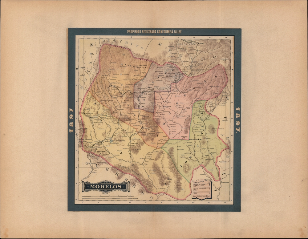
Morelos.
1897 (dated) 16.25 x 15.5 in (41.275 x 39.37 cm) 1 : 250000
1897 (dated) 16.25 x 15.5 in (41.275 x 39.37 cm) 1 : 250000
Description
A beautiful map of the Mexican state of Morelos, published in 1897 for the Atlas Geográfico de los Estados Unidos Mexicanos.
In the era of Porfirio Diaz's long rule, when this map was made, the economy of Morelos was dominated by sugar plantations, long a mainstay of the state economy and a source of socio-political tensions. As the plantations were increasingly commercialized, haciendas grew to absorb small peasant holdings, adding further fuel to discontent over inequality. Typical for the Porfiriato, Morelos saw investment in railways and other infrastructure, but these were seen as primarily benefitting the wealthy.
These conditions made Morelos ripe for revolution in the early 20th century, and produced one of modern Mexico's great leaders, Emiliano Zapata (1879 - 1919), a native of Anenecuilco, outside Ayala, south of Cuautla. Morelos served as a stronghold for the Zapatistas and was the site of many of their main political and military feats, including the 1911 Plan of Ayala, promulgated by Zapata, which called for comprehensive land reform.
A Closer Look
The state of Morelos is displayed with its constituent districts color-shaded for easy distinction. Cities and towns, pueblos, haciendas and ranchos, roads, railways (existing and planned), waterways, ancient ruins, and mines are labelled. Elevation is exhibited by hachures demonstrating the contrasts between the state's mountains and its valleys and basins.Imperial Residence and Revolutionary Flashpoint
Much of the modern history of the region has been defined by its relationship with Mexico City to the north (Morelos was broken off from the State of Mexico in 1869). This proximity ensured the state would serve as a battleground in the rebellions and wars of the 19th century, including during the French 'intervention' in Mexico of the 1860s. Emperor Maximillian chose the Jardin Borda in Cuernavaca as his summer residence, and improved roads and communication between the state capital and Mexico City.In the era of Porfirio Diaz's long rule, when this map was made, the economy of Morelos was dominated by sugar plantations, long a mainstay of the state economy and a source of socio-political tensions. As the plantations were increasingly commercialized, haciendas grew to absorb small peasant holdings, adding further fuel to discontent over inequality. Typical for the Porfiriato, Morelos saw investment in railways and other infrastructure, but these were seen as primarily benefitting the wealthy.
These conditions made Morelos ripe for revolution in the early 20th century, and produced one of modern Mexico's great leaders, Emiliano Zapata (1879 - 1919), a native of Anenecuilco, outside Ayala, south of Cuautla. Morelos served as a stronghold for the Zapatistas and was the site of many of their main political and military feats, including the 1911 Plan of Ayala, promulgated by Zapata, which called for comprehensive land reform.
Publication History and Census
This map was published in Mexico City in 1897 by Vega y Cie. It is based on the 1886 work of Antonio García Cubas and was updated with additional border work for the 1897 issue of the Atlas Geográfico de los Estados Unidos Mexicanos. The atlas is represented in several institutional collections but is extremely scarce on the market. The individual maps, likewise, are scarce to the market.Cartographer
Antonio Garcia y Cubas (July 24, 1832 - February 9, 1912) was a Mexican cartographer, writer, engineer, and geographer active in Mexico City in the second half of the 19th and the early 20th centuries. He is considered Mexico's first great geographer. Garcia y Cubas was born in Mexico City. He was orphaned at birth and was raised by is aunt. When he turned 18, he enrolled in the Dirección General de Industria, a government sponsored technical school. There he studied engineering and geography, which he further pursued at the Colegio de San Gregorio, Colegio de Ingenieros. He graduated with honors in geography and from 1856, became a member of the Sociedad Mexicana de Geografía y Estadística. His geographical work earned him the Order of Guadalupe, a Mexican second empire honorific, directly from the Emperor Maximillian. He published several atlases, including his important Atlas Geográfico, Estadístico e Histórico de la República Mexicana, and multiple decorative chromolithograph Atlas Pintoresco e Históricos covering Mexico, Cuba, Spain, and elsewhere. Today his work is scarce and highly desirable. More by this mapmaker...
Source
García Cubas, Antonio, Atlas Geográfico de los Estados Unidos Mexicanos, (Mexico City: Vega) 1897.
Atlas Geográfico de los Estados Unidos Mexicanos is a grand-format folio atlas of Mexico. It is based largely upon the Atlas Geográfico y Estadístico de los Estados Unidos Mexicanos published in 1887 by Antonio García Cubas and Debray. The present atlas incorporates the same maps, but adds a dramatic silver and gold border, which obscures the 1886 García Cubas imprint. It was issued during Porfirio Díaz's third term as president of Mexico - a period marked by rapid expansion of infrastructure and industry, including railroads, mines, bridges, roads, and broad scale electrification and waterworks. The atlases title page in this 1897 edition, celebrates Diaz with a large portrait and dedication. We have identified at least two editions of this atlas, both bearing the 1897 date: one by Cadena y Cie, features a red title page, another by Vega y Cie, featuring a blue title page. All 1897 editions we have identified have the silver borders, but these seem to be overprinted to cover an earlier gold border, with unidentifiable text and dating behind. We have been unable to find any examples with only the gold border. The atlases in general are showpieces of Mexican lithography in the golden age of the Porfiriato.
Condition
Very good. Verso repair to a centerfold separation. Verso reinforcement to margin.
References
Rumsey 5758.025 (1886 Edition).