This item has been sold, but you can get on the Waitlist to be notified if another example becomes available, or purchase a digital scan.
1935 Nason-Jones Map of Part of Papua New Guinea Marking Gold Deposits
MorobeDistrict-nasonjones-1935$775.00


Title
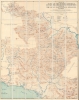
Map of Part of the Morobe District, New Guinea Mandated Territory, and of the Gulf and Central Divisions, Papua.
1935 (dated) 39.25 x 31.75 in (99.695 x 80.645 cm) 1 : 253440
1935 (dated) 39.25 x 31.75 in (99.695 x 80.645 cm) 1 : 253440
Description
A contrast of incredible detail alongside blank unexplored regions, this is a 1935 James Nason-Jones map of part of Papua New Guinea. A geologist and prospector, Nason-Jones mapped the area while searching for gold and oil and deposits of both are marked here.
A Closer Look
Depicting parts of Morobe, Gulf, Central, and Eastern Provinces, bright red notations mark gold ('G'), oil, and gas deposits throughout the region. The terrain appears in detail, with mountain peaks marked and elevations provided. Rivers and creeks are depicted in amazing detail as well. Camps are noted, along with different rock formations, such as sandstone, metamorphic, limestone, and granite. Bold lettering marks larger towns, such as Lae, Nadzab, and Kerema, while smaller villages dot the entire map. Small black boxes mark airfields, critical to mining efforts.Mining in Papua New Guinea
Gold was first discovered in Papua New Guinea in 1890, but the rough terrain and dense jungle made getting into the interior to find large quantities of gold very difficult. New Guinea became a Mandated Territory of Australia in 1922, eight years after Australia took possession of the German colony at the beginning of World War I. That same year Australia enacted a mining ordinance that legalized prospecting. New Guinea soon became a significant gold producer. Mining continued until 1941 and was suspended until the end of World War II in 1945. By the 1950s gold production exceeded 122,000 ounces per year. Mining did not really begin to dominate Papua New Guinea's economy until the 1970s and continues to this day. Today not only gold, but copper, silver, nickel, and cobalt, are extracted. In 2022, Papua New Guinea produced 50 metric tons of gold.Publication History and Census
This map was drawn by James Nason-Jones at the Lands Office in Port Moresby, Papua New Guinea, and published by H.E.C. Robinson in Sydney, Australia, in 1935. We note a single example cataloged in OCLC which is part of the collection at the State Library of New South Wales. An example is also part of the collection at the Australian War Memorial.CartographerS
James Nason-Jones (June 26, 1898 - November 6, 1972) was an English explorer, prospector, and geologist. Born in England, he may have fought with the Royal Flying Corps during World War I. Between 1927 and 1929 Nason-Jones was the leader of the Finsch Coast Geological Survey conducted by the Anglo-Persion Oil Company in New Guinea on behalf of the Australian Commonwealth Government. In the early 1930s Nason-Jones was back in New Guinea and conducted a survey of the gold regions of both Papua and the Mandated Territory from Port Moresby. While in New Guinea he began prospecting for himself, although we have been unable to determine his level of success. In 1934, during his 'work' in New Guinea, found the source of five major rivers in Papua and Papua New Guinea within fifteen miles of each other. In January 1938 he stated that he had mapped 15,000 square miles of Papua and Papua New Guinea while searching for gold and oil. More by this mapmaker...
Herbert Edward Cooper Robinson (November 18, 1856 - January 17, 1933) was a Sydney based Australian cartographer active in the late 19th and early 20th centuries. Cooper was born in Winchester, England and emigrated to Australia with his family, settling in Geelong, Victoria. At around 20 - 25 years of age, Robinson moved to Sydney to join the public service, where he mastered cartographic draftsmanship at the Lands Department. In 1882 he left the Lands Office to found a private firm with the Messrs. Higginbotham and Harris, under the imprint of 'Messrs. Higginbotham, Robinson, and Harris.' Within 2 years, both Higginbotham and Harris left the firm, driving it into bankruptcy and leaving Robinson on his own. In 1895, Robinson set up his own map publishing business at Wentworth Court, moving in 1906 to Phillip Street, and in 1913 to permanent location at 221-223 George Street, Sydney. In 1917, the firm formally incorporated as 'H. E. C. Robinson Ltd.' Although based in Sydney, the firm received multiple government contracts and opened annex firms in the Canberra. Robinson is best known for Australian city and regional guides, but he also published Sir Edgeworth David’s gigantic 1932 Geological Map of the Commonwealth of Australia and Donald Mackay's 1930+ aerial surveys of Australia. In addition to his printing work, in 1885, he became a founding member of the Geographical Society of Australasia. He became a fellow of the Royal Geographical Society in the late 1920s. Robinson had two children, Cecil Robinson and Eileen Robinson Brooks, both of whom emigrated to America. His daughter, Eileen, became a famous American stage actress. Learn More...
Condition
Very good. Dissected and mounted on linen in 30 panels. Accompanied by original binder.
References
Australian War Memorial G8140 svar W354. OCLC 224772420.