1662 Gerritsz and Blaeu City Map or Plan of Moscow, Russia
Moscow-gerritsz-1662$4,400.00


Title
Царствающои град Москва началнои город всех московских государствах. / Carstvajuščoi grad Moskva načalo I gorod všeh Moskovech I carstvach. Urbis Moskvae.
1662 (undated) 15.5 x 25 in (39.37 x 63.5 cm) 1 : 9700
1662 (undated) 15.5 x 25 in (39.37 x 63.5 cm) 1 : 9700
Description
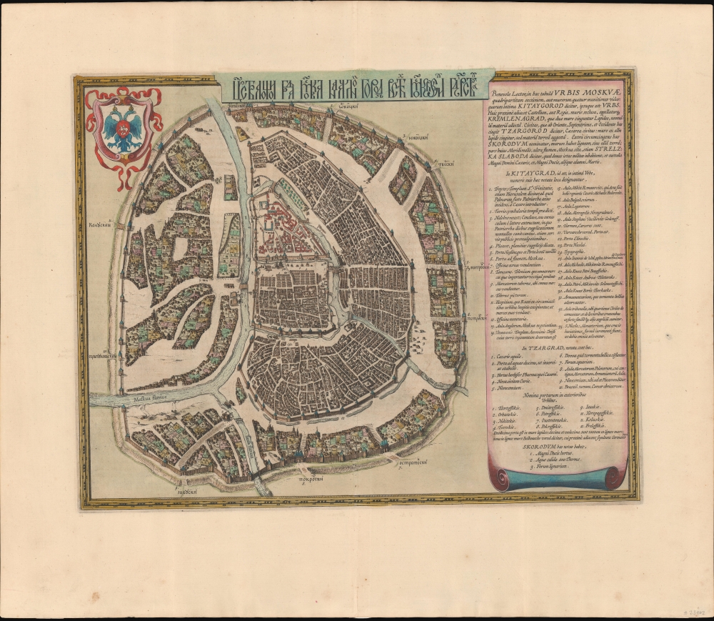
This is the 1662 Hessel Gerritsz and Willem Janszoon Blaeu city map or plan of Moscow, Russia. The map is significant as the dominant plan of Moscow in the 17th century. It is also significant for its innovative use of Cyrillic calligraphy to name both the city gates and in the map's titling - a first for non-Russian publishers. The Cyrillic calligraphy of the title is especially innovative, revealing the designer as a master of the style.
The map features an extensive textual key on a scroll at right. The guide introduces the four-part division of the city: Kitaygorod, the inner city; Kremlenagrad, the castle; Tzargorod, the middle city; and Skorodum with Strelzka Slaboda, or outer ring. It outlines the landmarks and properties of prominent citizens, highlighting 33 features within Kitaygorod, 10 within Tzargorod, and 3 within Skorodum. Additionally, the guide names, in Latin transliteration, the ten city gates. Notably, no landmarks are designated within Kremlenagrad, as they pertain to the sibling plate.
There are two states. The first state was engraved and separately published around 1613. It can be distinguished by a very simple unfinished outline of the scroll at right. The second state may have been engraved as early as the 1640s, but is not confirmed in an atlas until Willem Janszoon Blaeu's 1662 Atlas Maior. Earlier editions of partner Kremlenagrad map are known to have been published in Braun and Hogenburg's Civitates Orbis Terrarium, which does not rule out the possibility that Gerritsz's plan of Moscow was also published in Hogenburg's atlas. This present example was issued in the 1662 French edition of Blaeu's Atlas Maior. Scarce.
A Closer Look
The map is oriented west-by-south, with the Kremlin at its center. The city is displayed with its assorted walled sections, intersecting waterways, meandering streets, and distinctive buildings. Coverage embraces from the Moscow River to Zemlyanoy Gorod, which is surrounded by ramparts and a moat. This historical district in Moscow corresponds to the area between the Boulevard Ring and the Garden Ring roads in modern Moscow. A coat of arms bearing a double-headed imperial eagle, a sign of Russian rulers, is in the top left.The map features an extensive textual key on a scroll at right. The guide introduces the four-part division of the city: Kitaygorod, the inner city; Kremlenagrad, the castle; Tzargorod, the middle city; and Skorodum with Strelzka Slaboda, or outer ring. It outlines the landmarks and properties of prominent citizens, highlighting 33 features within Kitaygorod, 10 within Tzargorod, and 3 within Skorodum. Additionally, the guide names, in Latin transliteration, the ten city gates. Notably, no landmarks are designated within Kremlenagrad, as they pertain to the sibling plate.
Publication History and Census
It is commonly argued that this map derived from a survey ordered by Boris Fyodorovich Godunov, who ruled the Tsardom of Russia as de facto regent from c. 1585 to 1598, and then as the first non-Ririkid tsar from 1598 until 1605. The original plan is not believed to have survived.There are two states. The first state was engraved and separately published around 1613. It can be distinguished by a very simple unfinished outline of the scroll at right. The second state may have been engraved as early as the 1640s, but is not confirmed in an atlas until Willem Janszoon Blaeu's 1662 Atlas Maior. Earlier editions of partner Kremlenagrad map are known to have been published in Braun and Hogenburg's Civitates Orbis Terrarium, which does not rule out the possibility that Gerritsz's plan of Moscow was also published in Hogenburg's atlas. This present example was issued in the 1662 French edition of Blaeu's Atlas Maior. Scarce.
CartographerS
Hessel Gerritsz (1581 – September 4, 1632) was a Dutch engraver, cartographer, and publisher active in Amsterdam during the late 16th and early 17th centuries, among the most preeminent Dutch geographers of the 17th century. He was born in Assum, a town in northern Holland in 1581. As a young man he relocated to Alkmaar to accept an apprenticeship with Willem Jansz Blaeu (1571-1638). He followed Blaeu to Amsterdam shortly afterwards. By 1610 he has his own press, but remained close to Blaeu, who published many of his maps. In October of 1617 he was appointed the first official cartographer of the Vereenigde Oost-Indische Compagnie (Dutch East Indian Company) or VOC. This strategic position offered him unprecedented access to the most advanced and far-reaching cartographic data of the Dutch Golden Age. Unlike many cartographers of his period, Gerritsz was more than a simple scholar and showed a true fascination with the world and eagerness to learn more of the world he was mapping in a practical manner. In 1628 he joined a voyage to the New World which resulted in the production of his seminal maps, published by Joannes de Laet in his 1630 Beschrijvinghe van West-Indien; these would be aggressively copied by both the Blaeu and Hondius houses, and long represented the standard followed in the mapping of the new world. Among his other prominent works are a world map of 1612, a 1613 map of Russia by the brilliant Russian prince Fyodor II Borisovich Godunov (1589 – 1605), a 1618 map of the pacific that includes the first mapping of Australia, and an influential 1630 map of Florida. Gerritsz died in 1632. His position with the VOC, along with many of his printing plates, were taken over by Willem Janszoon Blaeu. More by this mapmaker...
Joan (Johannes) Blaeu (September 23, 1596 - December 21, 1673) was a Dutch cartographer active in the 17th century. Joan was the son of Willem Janszoon Blaeu, founder of the Blaeu firm. Like his father Willem, Johannes was born in Alkmaar, North Holland. He studied Law, attaining a doctorate, before moving to Amsterdam to join the family mapmaking business. In 1633, Willem arranged for Johannes to take over Hessel Gerritsz's position as the official chartmaker of the Dutch East India Company, although little is known of his work for that organization, which was by contract and oath secretive. What is known is his work supplying the fabulously wealthy VOC with charts was exceedingly profitable. Where other cartographers often fell into financial ruin, the Blaeu firm thrived. It was most likely those profits that allowed the firm to publish the Theatrum Orbis Terrarum, sive, Atlas Novus, their most significant and best-known publication. When Willem Blaeu died in 1638, Johannes, along with his brother Cornelius Blaeu (1616 - 1648) took over the management of the Blaeu firm. In 1662, Joan and Cornelius produced a vastly expanded and updated work, the Atlas Maior, whose handful of editions ranged from 9 to an astonishing 12 volumes. Under the brothers' capable management, the firm continued to prosper until the 1672 Great Amsterdam Fire destroyed their offices and most of their printing plates. Johannes Blaeu, witnessing the destruction of his life's work, died in despondence the following year. He is buried in the Dutch Reformist cemetery of Westerkerk. Johannes Blaeu was survived by his son, also Johannes but commonly called Joan II, who inherited the family's VOC contract, for whom he compiled maps until 1712. Learn More...
Source
Blaeu, W., Atlas Major, (Amsterdam: Blaeu) French, 1662.
In 1662 Joan Blaeu published his masterwork, which has been described as 'the greatest and finest atlas ever published' (Verwey, 1952): his monumental, eleven-volume Atlas Maior. This contained nearly six hundred maps, more than two hundred in excess of the Blaeus' mainstay the Atlas Novus. The former work already being renowned for the quality and beauty of its maps, Blaeu not only added copious material but improved the sophistication of his work: many of the newly-added maps utilized larger-sized presses and sheets, and the artistry applied to the engravings was often far superior to that of the earlier maps in the atlas - many of which by now were 30, and some more than 50 years old. Blaeu's Atlas Maior was published from 1662 to 1672, consisting of some 594 maps compiled into upwards of 9 volumes with some editions containing as many as 12 volumes. This triumphant work's publishing life was cut violently short when, in 1672, the Blaeu's mammoth workshop was destroyed by fire; surviving stock would be sold at auction between 1674 and 1677, occasionally appearing under the imprint of later Dutch printers such as Pieter Schenk and Pieter Mortier. The maps added to the Atlas Maior, owing to their tragically short publishing life, are among the hardest-to-find of the Blaeu maps.
Condition
Very good. Even overall toning. Large margins. Blank on verso.
References
OCLC 165859806.