This item has been sold, but you can get on the Waitlist to be notified if another example becomes available, or purchase a digital scan.
1657 Jansson View Map of Moscow, Russia
Moscow-jansson-1657$900.00

Title
Moscavw.
1657 (undated) 14.5 x 17 in (36.83 x 43.18 cm)
1657 (undated) 14.5 x 17 in (36.83 x 43.18 cm)
Description
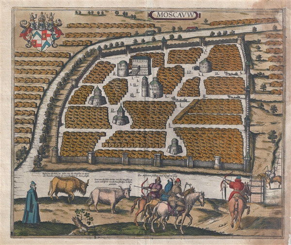
The rare 1657 Jansson view and map of Moscow, Russia. The view depicts Moscow as seen from an elevated point just above the Moskva River. The Neglinnaya River forms a partial moat around he city. The Kremlin, built between 1485 and 1530 to house the Russian Orthodox Church, is evident at the center of the view, where it is identified as Arx. The city is shown surrounded by strong wall though, at the time, Moscow was not significantly fortified. The great buildings are surrounded by eerily identical wood frame housing blocks separated by accurately while avenues.
The foreground features a pastoral scene with two bovines. The herbivore on the left is a European bison. The one on the right is an aurochs, a now extinct variety wild oxen, that once thrived throughout Eastern Europe and Asia. The fierce aurochs was one of the largest herbivores in postglacial Europe. It was aggressively hunted by the nobility of Europe until it began to dwindle in the 14th century. Some aurochs were still alive in 1575 when the image here was drawn, but by 1627 the last known female died in the Jaktorów forest, Poland, of natural causes.
Cartographically this view is derived from the 1575 Braun and Hogenberg view of Moscow, which, in turn, was derived from the Sigismund von Herberstein view published in 1563. Jansson acquired the Braun and Hogenberg city plates in the mid-1650s. Some he revised, some he used, some he trashed. The Moscow plate had a large crack down the right side, so Jansson cut it off, making this a slightly smaller map than the Braun and Hogenberg. It was published in Jansson's city book Theatrum Orbis Urbium. The preset map is much rarer than the Braun and Hogenberg edition.
CartographerS
Jan Jansson or Johannes Janssonius (1588 - 1664) was born in Arnhem, Holland. He was the son of a printer and bookseller and in 1612 married into the cartographically prominent Hondius family. Following his marriage he moved to Amsterdam where he worked as a book publisher. It was not until 1616 that Jansson produced his first maps, most of which were heavily influenced by Blaeu. In the mid 1630s Jansson partnered with his brother-in-law, Henricus Hondius, to produce his important work, the eleven volume Atlas Major. About this time, Jansson's name also begins to appear on Hondius reissues of notable Mercator/Hondius atlases. Jansson's last major work was his issue of the 1646 full edition of Jansson's English Country Maps. Following Jansson's death in 1664 the company was taken over by Jansson's brother-in-law Johannes Waesberger. Waesberger adopted the name of Jansonius and published a new Atlas Contractus in two volumes with Jansson's other son-in-law Elizée Weyerstraet with the imprint 'Joannis Janssonii haeredes' in 1666. These maps also refer to the firm of Janssonius-Waesbergius. The name of Moses Pitt, an English map publisher, was added to the Janssonius-Waesbergius imprint for maps printed in England for use in Pitt's English Atlas. More by this mapmaker...
Georg Braun (1541 – March 10, 1622) was a German deacon, viewmaker, and typo-geographer based in Cologne. Along with Franz Hogenberg (1535 - 1590), Braun is best known for his publication of the highly influential city atlas Civitates Orbis Terrarum. The six volume work, with some 546 views, was published between 1572 and 1617 and intended a companion to Abraham Ortelius' Theatrum Orbis Terrarum - thus certain obvious stylistic similarities. In compiling the Civitates Braun took on the role of editor while most of the engraving work was completed by Franz Hogenberg. Braun died, as he was born, in Cologne. Learn More...
Franz Hogenberg (1535 - 1590), often called 'Master Franz,' was a Flemish engraver active in the late 16th century. Hogenberg was born in Mechelen, the son of Nicolas Hogenberg, where he trained under the cartographer H. Terbruggen. He later relocated to Antwerp where he achieved success as an engraver, working with Abraham Ortelius, Hieronymus Cock, and others. In 1568, his name appeared on the list of those banned from the Netherlands by the Duke of Alva, forcing his family to flee to London. There he engraved for Christopher Saxon's Atlas of England and Wales. By 1570 he emigrated to Germany settling in Cologne. In Cologne he married his second wife, Agnes Lomar, with whom he had six children. In 1579 the couple were briefly imprisoned for holding illicit secret religious meetings, but were released in short order. Along with German cleric George Braun (1541 – March 10, 1622), Hogenberg issued the highly influential city atlas Civitates Orbis Terrarum. The six volume work, with some 546 views, was published between 1572 and 1617 and intended a companion to Abraham Ortelius' Thatrum Orbis Terrarum - thus certain obvious stylistic similarities. In compiling the Civitates Hogenberg took on the role of engraver while most of the editing was left to Georg Braun. Hogenberg died in Cologne, Germany, before the Civitates was completed. After his death, Hogenberg's work was continued by his son, Abraham Hogenberg, who, under the direction of Agnes, his mother, took over his father's enterprise at just 20. Learn More...
Source
Jansson, J., Theatrum Orbis Urbium, ad Septentrionalum Europae Plagam, (Amsterdam) 1657.
Condition
Good. Some staining along right margin. Some trimming but margins still wide. Latin test on verso. Old color. Minor centerfold reinforcement. Top right corner replaced in manuscript facsimile.
References
Koeman, Cornelis, Atlantes Neerlandici, vol. II, Ja 15, map 52 (p. 198). Van der Krogt, P., Koeman's Atlantes Neerlandici, vol IV -2.1, page 1187, #2862, st.2. Fauser 9204.