1929 National Park Service Motorists Guide Map of Yosemite National Park
MotoristsGuideYosemite-nps-1929$400.00


Title
Motorists Guide Map and Manual Yosemite National Park California. / Guide Map Yosemite National Park.
1929 (dated) 28.25 x 32.75 in (71.755 x 83.185 cm) 1 : 105600
1929 (dated) 28.25 x 32.75 in (71.755 x 83.185 cm) 1 : 105600
Description
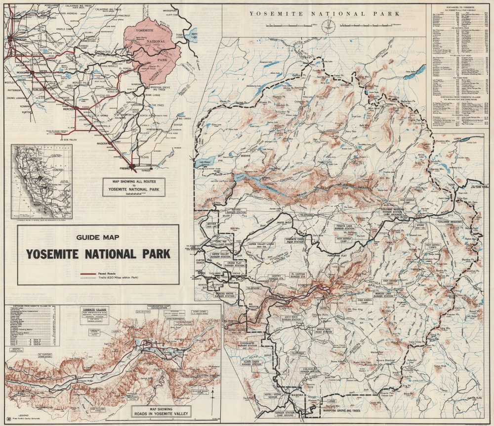
This is the 1929 National Park Service map of Yosemite National Park. Such maps allowed visitors to navigate the state's roads an visit the park in their own cars, or explore the park on foot via its network of hiking trails.
The Central Map
The focus is a relatively large-scale map of Yosemite. A bold dashed line delineates Yosemite's boundaries, while thinner dashed lines trace the park's trail network. 630 miles of trails crisscross Yosemite, according to the map. Bold black lines highlight roads, while the red line through Yosemite Valley emphasizes the only paved roads in the park. El Capitan, Bridal Veil Falls, and Yosemite Falls are labeled. Text boxes mark ranger stations, telephones, hotels, and campsites. Mountain peaks, waterfalls, lakes, and other natural landmarks and labeled.The Smaller Maps
Three smaller maps appear as well. Of greatest interest is the detail map of the Yosemite Valley. Here Yosemite's most iconic sites identified, along with campsites, ranger stations, Yosemite Village, Yosemite Lodge, and the Sentinel Hotel. Above this map, in the upper left, a map highlights the routes to Yosemite from Fresno and Stockton and a much smaller map illustrates the road network connecting to all of California's national parks and monuments.Publication History and Census
This map was created engraved and printed by the U.S. Geological Survey for the National Park Service in 1929. Editions of this map were published as early as 1924 through at least 1932. This is the only known cataloged example of the 1929 edition. We note at most a dozen cataloged examples of all other editions combined.CartographerS
The National Park Service (August 25, 1916 - Present) is a United States government agency tasked with managing all national parks, most national monuments, and other historical, recreational, and natural properties. Part of the U.S. Department of the Interior, the Service oversaw 423 units in 2020, sixty-three of which were national parks, and employed over 12,500 people. More by this mapmaker...
The United States Geological Survey (1878 - Present), aka the U.S.G.S., is a scientific agency of the United States government, which was founded in 1879. USGS scientists study the landscape of the United States, its natural resources, and the natural hazards that threaten it. The organization has four major science disciplines: biology, geography, geology, and hydrology. It is a bureau of the United States Department of the Interior and is the department's only scientific agency. Learn More...
Condition
Very good. Light wear along original fold lines. Closed margin tear professionally repaired on verso. Text on verso.