This item has been sold, but you can get on the Waitlist to be notified if another example becomes available, or purchase a digital scan.
1826 Bulla Comparative Chart of the World's Mountains and Rivers
MountainsRivers-bulla-1830$925.00

Title
Tableau Comparatif des Principales Montanges, des Principaux Fleuves et Cataractes de la Terre. D'après les observations des plus Savants Voyageurs.
1830 (undated) 21.5 x 30 in (54.61 x 76.2 cm)
1830 (undated) 21.5 x 30 in (54.61 x 76.2 cm)
Description
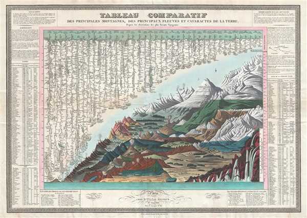
This is François Bulla's rare 1826 comparative mountains and rivers chart, one of the first charts to integrate mountains and rivers on a single chart, and the first to add waterfalls. For a long time, this map was considered by scholars to be the earliest known chart to consolidate comparative mountains and rivers charts into a single sheet. Today, that honor has been superseded by the 1823 William Darton chart. Nonetheless, the present chart is doubtless the second such to appear and, like the Darton, is a scarce separate issue. As a comparative chart, this Bulla is far more sophisticated than Darton's earlier chart, incorporating a larger format, significant additional information, and add comparative waterfalls.
The comparative mountains section, occupying the lower right half of this chart, details the principle mountains of the world. Ranges are color coded to show different types of vegetation and numerically reference tables in the lower right quadrant. The elevations of several important cities including Paris, Rome, London, Geneva, Mexico, Bogota, and Quito, among others, are noted. There are also extensive notations on vegetation, volcanic activity, and lichen, much of which is no doubt influenced by Humboldt. The Himalayan peak Dhaulagiri is identified as the world's greatest mountain. Even the aeronaut ballooning feats of Frenchman Gay-Lussac who attained an altitude of 23,000 feet in 1808, and the Italian meteorologist, Pascal Andreoli and Carlo Brioschi, who rose to 27,000 feet over Padua, also in 1808, are noted
The upper left portion of this chart is dominated by the world's greatest rivers. Bulla attempts not only to express the lengths of the various rivers, but also details regarding their course and sources. All along each river important lakes, cities, directions, and distance measurements are noted. Here the Amazon is identified as the world's greatest rive, followed by the Mississippi. The Nile comes up a sad sixth, although admittedly its full length had yet to be explored.
This is the first appearance of waterfalls on a comparative mountains and rivers chart. As the great waterfalls of South America and Africa remained as yet largely unknown in European intellectual circles, most of the focus is on European waterfalls with the Chute de Gavarnie identified as the world's greatest cascade.
We have identified at least two variants of his chart, but the plate seems identical. One was issued by Bulla et Fontana, the other by Chez Bulla. It is unclear which appeared first, or if they appeared simultaneously as all are assigned to 1826. Today examples of Bulla's charts are extremely rare.
CartographerS
François Bulla (fl. c. 1814 - 1855) was a French engraver, printmaker, lithographer, and printer. Born in Tessin, Bulla opened his business at 98, Rue du Temple around 1814 and moved to 38, Rue Saint-Jacques in 1821. Bulla published a catalog of his work in 1838 entitled Catalogue général des estampes et lithographies compost le fond de F. Bulla, éditeur, quaint Saint-Michel, 25 that was printed by the Imprimerie de Ducessois. Bulla's business was described in the Bazar Parisien in 1826 in this manner:
Possesses a considerable stock of prints in all formats. A print of Girodet's painting La bataille de la révolte du Caire stands out, along with allegorical and historical prints, as well as prints illustrating religious subjects. He accompanies these with a series of beautifully executed landscapes.The firm moved to Rome in 1840, establishing itself at 2 Via del Vantaggio not far from the Piazza del Popolo. In 1848, Bulla entered into a short-lived partnership with Cereghetti; he then moved on to a partnership with Stampa, a Spanish editor, in 1849. Bulla retired in 1855. Bulla had five sons: Eugène (known as Bulla ainé), Joseph, Antoine, Laurent, and Jean-Baptiste. All five of his sons would adopt their father's profession and become either editors or printers. His two oldest sons established their own firms. Antoine was sent by his father to Cadiz in 1849, but when François retired in 1855, Antoine took over his father's share of the partnership with Stampa. The firm still operates to this day in Rome, Italy and is owned by Bulla's descendants. More by this mapmaker...
Charles Picquet (April 15, 1771 – January 15, 1827) was a French cartographer active in Paris during the Napoleonic and post-Napoleonic Eras. Picquet was born in Romagna-sous-Montfaucon, Meuse, France. From about 1798 Picquet supplied maps to the Dépôt de la Guerre. From 1806 he was appointed to Napoleon's Cabinet Topographique. Being politically dexterous, he was able to retain this position after the fall of Napoleon under both Louis XVIII and Charles X. Under Louis XVIII he also obtained the Brevet de Géographe Ordinaire du Cabinet Topographique. He worked with the cartographer Adrien-Hubert Brué on a major atlas project. When Charles Picquet died in 1827, his son, Pierre-Jacques Picquet, continued to publish under his father's imprint name well into the middle part of the 19th century. Learn More...
Armand Joseph Lallemand (c. 1810 - 1871) was an engraver and map publisher based in Paris during the mid-19th century. Most of Lallemand's work focused on landscapes and building vies, though he did take part in a few cartographic ventures, including the production of an atlas with Alexandre Emile Lapie and several tourist pocket maps of Paris. Learn More...
Condition
Very good. Even overall toning. Wear along original fold lines. Blank on verso.
References
OCLC 868342746. Wolter, John A., The Heights of Mountains and the Lenghts of Rivers, p. 195.