This item has been sold, but you can get on the Waitlist to be notified if another example becomes available, or purchase a digital scan.
1862 Philip Comparative Map or Chart of the World's Mountains and Rivers
MountainsRivers-philip-1862$75.00

Title
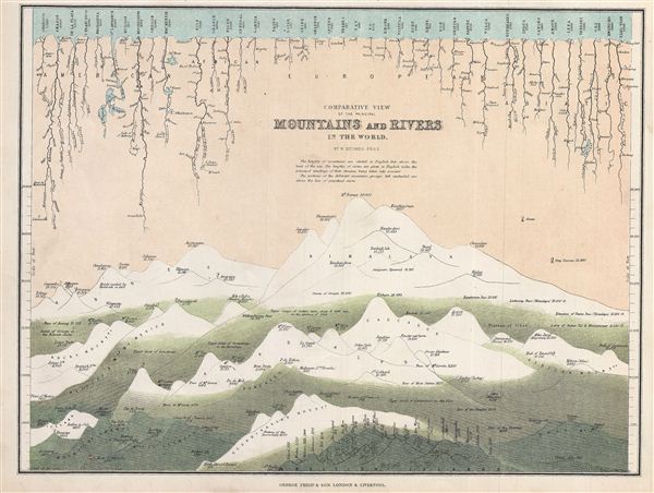
Comparative View of the Principal Mountains and Rivers in the World.
1862 (undtaed) 10 x 12.5 in (25.4 x 31.75 cm)
1862 (undtaed) 10 x 12.5 in (25.4 x 31.75 cm)
Description
This is a fine example of George Philip's 1862 comparative view of the world's principal mountains and rivers. Details the world's great mountains divided according to mountain ranges, Himalayas, Alps, Andes, and so on, while principal rivers are grouped according to continent. When this chart was made, the highest peak in the Himalayan range, Mt. everest, is recorded to be 29,002 ft. (today it is recorded to be 29,029 ft.), the highest peak noted in the Andes is Aconcagua, in the Alps Mt. Blanc, in the Caucasus elburz, in the Rockies Mt. Brown. The longest river noted here is the Mississippi. Also notes important cities, falls, and lakes that the rivers flow through. This map was prepared by William Hughes F. R. G. S. and published by George Philip & Sons in 1862.
Cartographer
George Philip (1800 - 1882) was a map publisher and cartographer active in the mid to late-19th century. Philip was born into a Calvinst family in Huntly, Aberdeenshire, Scotland. Around 1819 he apprenticed himself to William Grapel, a Liverpool printer and bookseller. Fifteen years later, in 1834, Philip founded his own Liverpool book and map firm. Philip's earliest cartographic ventures were mostly educational material issued in tandem with John Bartholomew Sr., August Petermann, and William Hughes. In 1848, Philip admitted his son, George Philip Jr. (1823 - 1902) into the firm, renaming it George Philip and Son Ltd. George Philip Jr. ran the firm until his death in 1902, by which time it had developed into a major publishing concern. His successors established the London Geographical Institute, a factory where they embraced modern printing techniques to produce thousands of economical and high quality maps. In April 1988, George Philip & Son was acquired by Octopus Publishing, a branch of Reed International. Nonetheless, today the firm trades and publishes to this day as George Philip and Son. More by this mapmaker...
Condition
Very good. Blank on verso.