This item has been sold, but you can get on the Waitlist to be notified if another example becomes available, or purchase a digital scan.
1934 Higgins Map of Mount Desert Island, Maine
MountDesertIsland-higgins-1934$475.00

Title
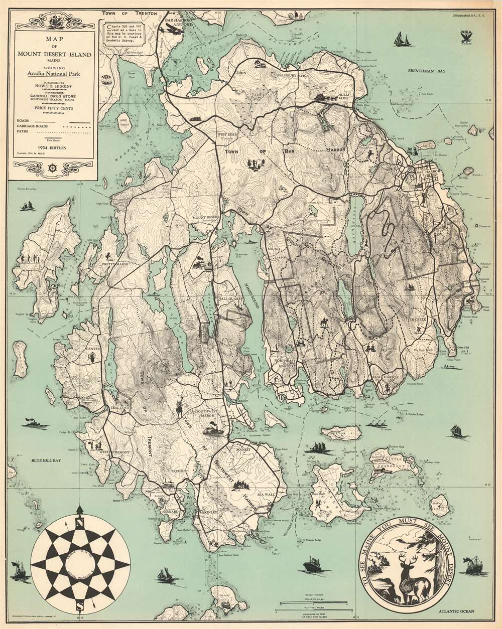
Map of Mount Desert Island Maine Showing Acadia National Park.
1934 (dated) 29.75 x 23.75 in (75.565 x 60.325 cm) 1 : 40000
1934 (dated) 29.75 x 23.75 in (75.565 x 60.325 cm) 1 : 40000
Description
This is a 1934 Howe D. Higgins map of Mount Desert Island, Maine. Depicting the island in its entirety, Higgins employed two U.S. Coast and Geodetic Survey charts to create the base map and then added the delightful vignettes and a different typeface. Thick black lines trace the island's road network, while dashed lines highlight its famed carriage roads. Depth soundings appear along the coasts, particularly in the coves and harbors.
Mount Desert Island
Popularized as a vacation destination during the 19th century, Mount Desert Island is renowned for its exceptional natural beauty. First brought to public attention by painters of the Hudson River School, tourists and nature lovers began flocking to the island in the 1860s. By 1880, the island hosted thirty hotels, all vying for tourist dollars. By the 'Gay Nineties,' American social elites and business magnates, including the Rockefellers, Fords, Vanderbilts, and Carnegies, had built summer homes on the islands' most desirable land. Eventually, the Rockefellers acquired most of the island, donating it to the Federal government as a public recreation area, ultimately known as Acadia National Park.Acadia National Park
Acadia was initially established as Sieur de Monts National Monument by President Woodrow Wilson in July 1916. In February 1919, the area's status was officially changed from a National Monument to a National Park, making it the first National Park east of the Mississippi. With the change to a National Park came a name change to Lafayette National Park. It would not be until January 1929 that the park would be renamed Acadia. Acadia is unlike most other National Parks as its creation was encouraged by numerous private individuals. Most prominent among these was John. D. Rockefeller Jr. who purchased a summer home in Bass Harbor in 1910. Rockefeller aggressively purchased any land for sale, eventually acquiring most of the island. He sponsored the construction of an elaborate system of carriage roads, making generally accessible what he rightly considered 'one of the greatest views in the world.'Publication History and Census
This map was created and published by Howe D. Higgins in 1934. One example is cataloged in OCLC and is part of the collection at the University of Kansas. Another example is part of the collection at the Southwest Harbor Public Library. Extremely rare.Cartographer
Howe Dwaine or Duane Higgins (February 26, 1894 - May 31, 1974) was an American artist, craftsman, and customs officer. Born at Town Hill, Bar Harbor, Maine, Higgins joined the Customs Service in 1918 and spent his first year in Presque Isle, Maine. he Became Deputy Collector of Customs in Southwest Harbor, Maine the following year. Eventually he was appointed Inspector of Customs and his wife Athol was ade Deputy Collector. During Prohibition, Higgins vowed to crack down on rum running, which was big business in that part of Maine. He would spend hours staking out places where he believed rum runners to land, many times the entire night. Higgins's position on rum running proved to be generally unpopular, because many respected people in the Mount Desert Island community were involved and they spent their money locally, giving the local populace a boost during the Great Depression. Higgins married his wife Athol M. Kane on December 22, 1917 in Bath, Maine. More by this mapmaker...
Condition
Very good. Minor margin reinstatement to the upper right corner. Minor archival reinforcements in places along edges on verso.
References
OCLC 710854600.