This item has been sold, but you can get on the Waitlist to be notified if another example becomes available, or purchase a digital scan.
1867 Holmes Map of Murray Hill Farm, Midtown Manhattan, New York City
MurrayHillNewYork-holmes-1867$1,500.00

Title
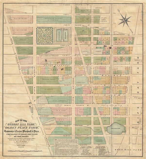
Map of the 'Murray Hill Farm,' 'Ogden Place Farm,' Lawrence & Astor, Wiswall & Price, Corporation, Wm. Wright, John Taylor and other Property.
1867 (dated) 25 x 25 in (63.5 x 63.5 cm)
1867 (dated) 25 x 25 in (63.5 x 63.5 cm)
Description
An exceptional and extremely scarce 1867 John Bute Holmes map of New York City's Midtown East and Murray Hill neighborhoods. Holmes' map covers from 30th street to 44th street and from Broadway (Bloomingdale Road) to Lexington Avenue. This includes some of New York City's most desirable real estate, including Bryant Park, the New York Public Library, the site of the Empire State Building, 42nd Street, and the most prestigious extensions of 5th Avenue, Madison Avenue, Park Avenue (identified here as 4th Ave), and Lexington Avenue.
This map is one of a series of 21 maps prepared by Holmes to illustrate the early farms and topography of east central Manhattan ghost overlaid on the c. 1867 street grid. Here, as the map's title suggests, Holmes identifies the large 'Murray Hill Farm,' as well as 'Ogden Place Farm,' and smaller land holdings associated with Lawrence, Astor, Wiswall, Price, Wright and Taylor.
The Murray Hill Farm is named after Robert Murray (1721–1786), an 18th century Quaker shipping magnate. Murray leased the vast tract of land between Broadway and Lexington, 30th and 38th Street, from New York City in 1762. At the highest point on his new property, a since flattened glacial till soon to be known as Murray Hill, he built a sprawling manor house called Inclenberg. The Murray family retained the property throughout the Revolutionary War. When the British invaded New York City, the family matriarch Mary Lindley Murray is credited with delaying British commander William Howe. Through her feminine wiles, Mrs. Murray enticed Howe and his officers to tea at Inclenberg, thereby giving the American freedom fighters ample time to make a quick retreat.
Ogden Place Farm was situated just to the northeast between Broadway (Bloomingdale Road) and Madison Avenue, 39th street and 34th street. This gentlemanly estate, build by William Ogden on land rented from the city, was the site of the gothic castle Waddell Villa, a hub for New York City elite social life well into the 1850s. The farm was partially partitioned among the heirs of William Ogden in 1838. The remainder of the farm was further partitioned by the city and sold as 187 individual lots in 1840.
The reaming farms, associated with notable New York City families like Astor, Lawrence, Wiswall, Price, Wright, and Taylor, were similarly reverted to common lands and sold as lots in the first half of the 19th century following the issue of the 1811 Commissioner's Plan and the solidification of the Manhattan street grid.
It is noteworthy that this map is extremely rare. While a few examples do exist in institutional collections, this may well be the only remaining example in private hands. This is a once in a lifetime opportunity for the serious New York collector.
CartographerS
John Bute Holmes (March 31, 1822 - May 21, 1887) was an Irish civil engineer, city surveyor, and mapmaker based in New York City in the middle to latter 19th century. Holmes was described as a 'short, stout man, with curly gray hair, a smooth face, and a short, thick neck.' Holmes' father-in-law supplied funds for him to immigrate to America in 1840 and shortly thereafter, in 1844, he established himself in New York City. He briefly returned to Europe before once again settling in New York City in 1848. Apparently, according to several New York Times articles dating to the 1870s, Holmes was a man of dubious personal and moral character. He was involved in several legal disputes most of which were associated with his outrageous - even by modern standards - womanizing. In 1857 he was convicted of forgery of a marriage document and sentenced to 15 years of hard labor at Sing Sing, of which he served 5 before wealthy associates interceded on his behalf for an early release. Holmes seems to have been married to several different women at the same time and to have had an unfortunate attraction to exceptionally young women - one of whom, 16 year old May Chamberlayne claimed to be his wife and sued him for 50,000 USD. On another occasion he was found guilty of killing Brooklyn policeman David Gourly with whose wife he 'had been intimate.' Another woman, Miss Abrams, who he hired as a housekeeper, was repeatedly attacked by Holmes and ultimately driven to madness and was consigned to Bellevue Hospital, where she died. Although he attempted to flee the country rather than face conviction for 4th degree manslaughter, he was ultimately arrested and served one year in prison. During the American Civil War he ran for Alderman of the First Ward, in New York. Despite his legal issues, Holmes was a man of considerable means, with a personal fortune estimated between 100,000 and 500,000 USD - a significant sum in the late 19th century. Much of his wealth is associated with a series of important cadastral maps produced between 1867 and 1875 while he was employed as a surveyor and civil engineer under the corrupt Tweed regime. When Holmes died of an 'apoplectic fit' there was considerable wrangling over his estate among his 7 heirs and 11 children. The cream of his estate where his maps, some of which were valued at more than 30,000 USD in 1887. Holmes lived on a large farm-estate in Fanwood New Jersey. More by this mapmaker...
Arthur A. Brown (July 7, 1827 - June 1, 1895) was a New York lithographer active in the mid to late 19th century. Brown was born in Ireland and emigrated to New York in 1849. At the time of immigration, his occupation was listed as a tailor. By 1855 he appears in the New York State Census as a lithographer. In the 1869s he printed extensively for the City Clerk's office both in Manhattan and Brooklyn. His firm, A. Brown and Company was established around 1860. His office was initially located at 179 Broadway, then 47 Nassau (1863 - 1865), 9 and 11 Thames Street (1866 - 1874), 306 Broadway (1875 - 1881), and 116 Duane Street (1882 - 1894). Brown died in 1895 and is interred in Cyprus Hills Cemetery, Brooklyn. Learn More...
Condition
Very good. Professionally backed with archival tissue and partially remargined.
References
Bulletin of the New York Public Library, vol. I p. 142. OCLC #50565697, giving additional examples at the New York State Library and Princeton. Not in Haskell or Rumsey.