This item has been sold, but you can get on the Waitlist to be notified if another example becomes available, or purchase a digital scan.
1891 Charles Snow Map of Narragansett Bay, Rhode Island and Massachusetts
NarragansettBay-snow-1891$175.00

Title
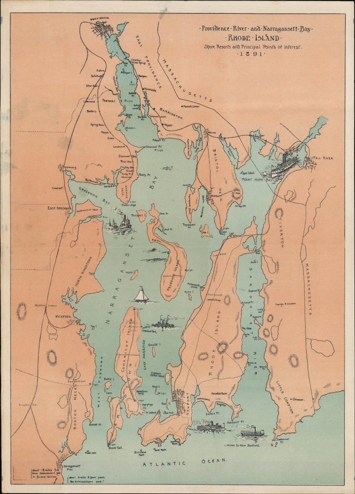
Providence River and Narragansett Bay Rhode Island. Shore resorts and principal points of interest, 1891
1891 (dated) 13.5 x 9.5 in (34.29 x 24.13 cm) 1 : 150000
1891 (dated) 13.5 x 9.5 in (34.29 x 24.13 cm) 1 : 150000
Description
This is a finely detailed 1891 Charles Snow and Forbes Lithographing map of Narragansett Bay, spanning parts of Rhode Island and Massachusetts, published as the region was transforming into a premier summer retreat for America's mercantile aristocracy.
By the 1890s, regional tourism had become a dominant economic force. This period, often dubbed the 'Gay Nineties,' saw a surge in the construction of grand hotels, entertainment venues, golf courses, and other leisure amenities. Of particular note on this map is the prominent depiction of Narragansett Pier, which at the time rivaled Newport as a fashionable resort. Its centerpiece was a grand casino designed by the architectural firm McKim, Mead and White, with landscaping by Frederick Law Olmsted. Although the casino was destroyed by fire in 1900, leaving only the resort's iconic granite towers and gate, the Pier's moment of prominence reflects the broader rise of Narragansett Bay as a luxury summer destination.
A Closer Look
The map captures Narragansett Bay and its surroundings, with Providence at the top, Narragansett Pier at the lower left, and Sakonnet Point at the lower right. Cities and towns are clearly marked, along with roads, railways, lighthouses, islands, and a wealth of maritime features, including points, rocks, and channels. Steamboats and sailing vessels are illustrated throughout the bay, animating the waters with a sense of period activity. Although railroads are not labeled, the lines depicted correspond to the Narragansett Pier Railroad, the Providence, Warren and Bristol Railroad, and the Old Colony Railroad.Narragansett Bay
For centuries, Narragansett Bay was a hub of maritime commerce and fishing, like many coastal New England communities. By the late 19th century, however, it was rapidly evolving into a center of leisure and seasonal escape. Facilitated by new rail and steamship routes, affluent families from Boston, New York, and beyond were drawn to the bay's temperate climate and scenic beauty. Newport, located near the bottom of the map, became synonymous with Gilded Age luxury, attracting America's elite who erected opulent summer 'cottages' along its shoreline.By the 1890s, regional tourism had become a dominant economic force. This period, often dubbed the 'Gay Nineties,' saw a surge in the construction of grand hotels, entertainment venues, golf courses, and other leisure amenities. Of particular note on this map is the prominent depiction of Narragansett Pier, which at the time rivaled Newport as a fashionable resort. Its centerpiece was a grand casino designed by the architectural firm McKim, Mead and White, with landscaping by Frederick Law Olmsted. Although the casino was destroyed by fire in 1900, leaving only the resort's iconic granite towers and gate, the Pier's moment of prominence reflects the broader rise of Narragansett Bay as a luxury summer destination.
Publication History and Census
This map contains no publication information but was produced in 1891. We are only aware of two other examples of this map, held by the University of Michigan and the Rhode Island Historical Society. The R.I.H.S. listing attributes it to Charles N. Snow and Forbes Lithograph Co. of Boston.Cartographer
William H. Forbes (1836 - February 3, 1915) was an English-American businessman and printer active in the second half of the 19th and early 20th centuries. Forbes was born in Liverpool England and immigrated to the United States at 12 years old. In the United States, he lived with Quaker relatives at Milton-on-the-Hudson, who provided him with a top-notch education. Forbes apprenticed as lithographer under H. A. Strong in New York. Following his maturity, he relocated to Boston in 1861, founding William H. Forbes and Company shortly after, in 1862. Forbes proved an excellent lithographer and savvy businessman. He reorganized his growing printing concern in 1875, incorporating as Forbes Lithograph Manufacturing Company in 1875. They focused on lithography, embossing, Albertype process printing, typesetting, copper and steel plate printing, and photolithography. At its height, Forbes Lithograph Manufacturing Company had over 70 presses located in Boston, New York, Chicago, and London, and staffed more than 600 workers, including 60 designers, artists, engravers, and lithograph artists. By 1881, Forbes himself had taken a back seat, working as the company treasurer, with William P. Hunt serving as president. In his personal life Forbes was well liked. He married the sister of well-known lithographer Louis Prang. After his death, the firm was taken over by his son, William S. Forbes. During World War II they were major printers of Allied military currency, producing more than 4 billion notes. The firm went out of business in the second half of the 20th century. More by this mapmaker...
Condition
Very good. Light wear along original centerfold.
References
OCLC 793037367. Rhode Island Historical Society Map # 4393 Pocket Map B4 F18.