This item has been sold, but you can get on the Waitlist to be notified if another example becomes available, or purchase a digital scan.
1873 U.S. Coast Survey Map of Narragansett Bay, Rhode Island
NarragansettBay-uscs-1873$375.00

Title
Narragansett Bay.
1873 (dated) 46 x 31 in (116.84 x 78.74 cm)
1873 (dated) 46 x 31 in (116.84 x 78.74 cm)
Description
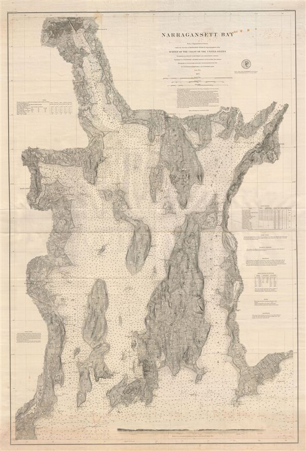
A scarce 1873 nautical chart of Narragansett Bay, Rhode Island, issued by the U.S. Coast Survey. Printed on two sheets which have been joined at the center, this fine working nautical chart covers the entirety of Narragansett Bay from Providence Rhode Island to the Pettaquamscutt River and from east Greenwich and Apponaug to Fall River, inclusive of Newport, Warren, Rhode Island (the island), Bristol, Connecticut Island, and Prudence Island. The whole features countless depth soundings in feet as well as a wealth of practical information for the mariner, including notes on light houses, soundings, magnetic variation, light vessels, elevations, and tides. A land profile view at the base of the map focuses on the 'Approaches to Narragansett Bay, Beavertail Light bearing N. by e. ½ e. distant 3 Mile.'
In addition to maritime detail, this map also features extraordinary inland detail, offering beautifully engraved topography, with individual streets, buildings, towns, farms, rivers lakes roads, rail lines and forests clearly in evidence. In Providence, Brown University's University Hall, Manning Hall, and Hope College buildings are included though not specifically labeled.
Work on this chart began in the 1860s under A. D. Bache and was subsequently continued under Benjamin Pierce, the present example being the highest expression of the Coast Survey's 19th century work in this region. The triangulation for this chart was completed by e. Blunt, S. C. McCorkle, and A. M. Harrison. The topography is the work of A. M Harrison, C. Hosmer, and H. G. Ogden. The hydrography was accomplished by G. S. Blake, J. R. Goldsborough, W. P. Trowbridge, H. Mitchell, and F. P. Webber. The scale is 1:40000. This map is an independent issue chart on thick stock and represents Coast Survey Chart no. 353.
Cartographer
The Office of the Coast Survey (1807 - present) founded in 1807 by President Thomas Jefferson and Secretary of Commerce Albert Gallatin, is the oldest scientific organization in the U.S. Federal Government. Jefferson created the "Survey of the Coast," as it was then called, in response to a need for accurate navigational charts of the new nation's coasts and harbors. The spirit of the Coast Survey was defined by its first two superintendents. The first superintendent of the Coast Survey was Swiss immigrant and West Point mathematics professor Ferdinand Hassler. Under the direction of Hassler, from 1816 to 1843, the ideological and scientific foundations for the Coast Survey were established. These included using the most advanced techniques and most sophisticated equipment as well as an unstinting attention to detail. Hassler devised a labor intensive triangulation system whereby the entire coast was divided into a series of enormous triangles. These were in turn subdivided into smaller triangulation units that were then individually surveyed. Employing this exacting technique on such a massive scale had never before been attempted. Consequently, Hassler and the Coast Survey under him developed a reputation for uncompromising dedication to the principles of accuracy and excellence. Unfortunately, despite being a masterful surveyor, Hassler was abrasive and politically unpopular, twice losing congressional funding for the Coast Survey. Nonetheless, Hassler led the Coast Survey until his death in 1843, at which time Alexander Dallas Bache, a great-grandson of Benjamin Franklin, took the helm. Bache was fully dedicated to the principles established by Hassler, but proved more politically astute and successfully lobbied Congress to liberally fund the endeavor. Under the leadership of A. D. Bache, the Coast Survey completed its most important work. Moreover, during his long tenure with the Coast Survey, from 1843 to 1865, Bache was a steadfast advocate of American science and navigation and in fact founded the American Academy of Sciences. Bache was succeeded by Benjamin Pierce who ran the Survey from 1867 to 1874. Pierce was in turn succeeded by Carlile Pollock Patterson who was Superintendent from 1874 to 1881. In 1878, under Patterson's superintendence, the U.S. Coast Survey was reorganized as the U.S. Coast and Geodetic Survey (C & GS) to accommodate topographic as well as nautical surveys. Today the Coast Survey is part of the National Oceanic and Atmospheric Administration or NOAA as the National Geodetic Survey. More by this mapmaker...
Condition
Very good. Minor foxing here and there. Some additional toning along the bottom of the map.