1636 Hondius/ Jansson Map of Turkey and Cyprus in an Apparent Appendix Issue
NatoliaAsiaMinor-hondius-1636$750.00

Title
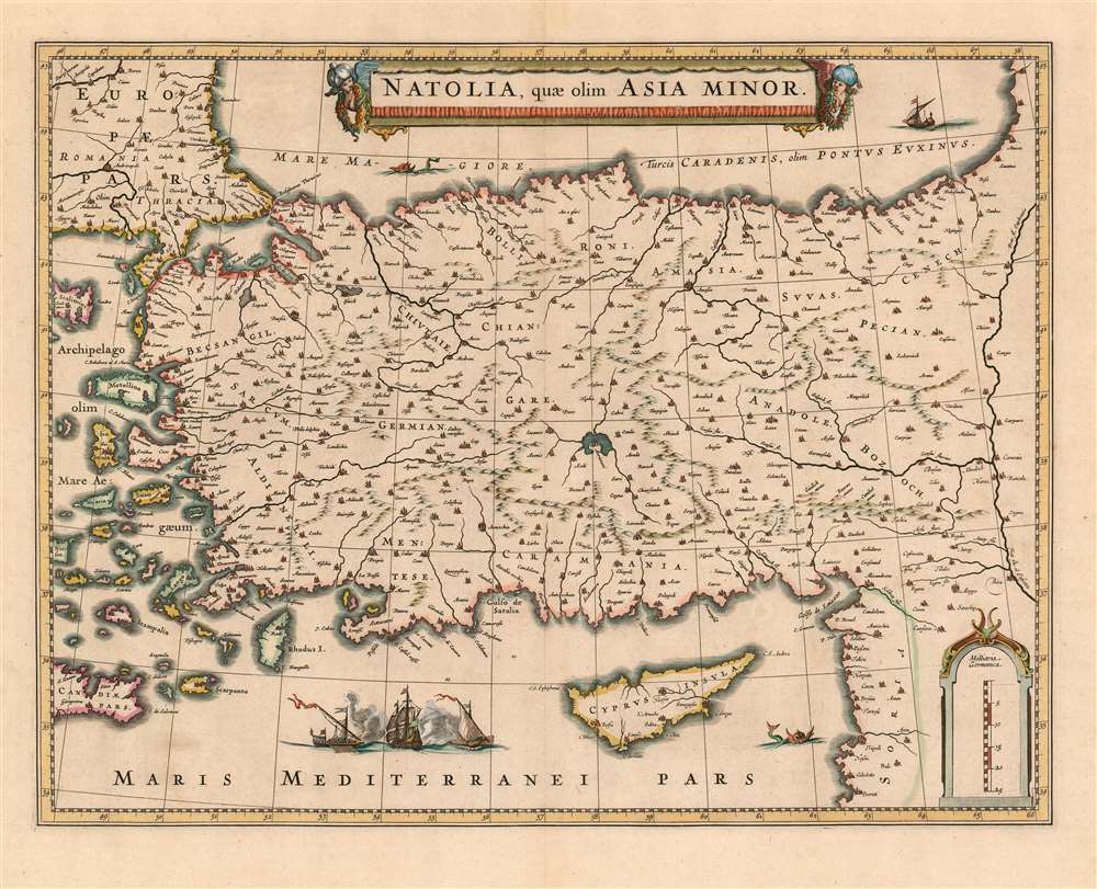
Natolia, quae olim Asia Minor.
1636 (undated) 15 x 19.5 in (38.1 x 49.53 cm) 1 : 3500000
1636 (undated) 15 x 19.5 in (38.1 x 49.53 cm) 1 : 3500000
Description
This 1636 map of Asia Minor and Cyprus was engraved by Jansson in 1636 for inclusion in his business partner Henry Hondius's atlases. This example, lacking verso text and exhibiting a bold, sharp strike, was probably an early appendix issue intended for distribution to previous subscribers to Hondius' atlas. The map depicts the region from the Aegean Sea to the Euphrates River, and from the Black Sea to Cyprus and the Mediterranean Sea. The beautifully engraved map is embellished with an evocative cartouche flanked by two turbaned putti. West of Cyprus, two Ottoman triremes blast away at a square-rigged ship, alluding to the long contention between Turkish and Christian European powers over the region. Hondius and Jansson produced this map quite shortly after fellow Amsterdam mapmaker Blaeu produced a virtually identical map in 1634. Despite the heated competition evident between the two mapmaking giants, the map's geographical data was not strictly fresh - the 16th century cartographic giant, Gastaldi, remained authoritative with respect to this region.
Publication History and Census
This map was executed for inclusion in Henry Hondius' Atlas, appearing first in a 1636 German edition and remaining in various language editions published by both Hondius and Jansson into the 1680s. Despite its long history in print, we only see three examples of the separate map in institutional collections. Examples of various editions appear on the market from time to time. The absence of verso text on the present example suggests that this was an Appendix issue of the map, provided to owners of previous editions of the Hondius atlas to be tipped in, or to be added to a composite atlas. The sharp, even strike and the palette of the original hand color supports an early date for this example.CartographerS
Henricus Hondius II (1597 – August 16, 1651) was a Dutch engraver, cartographer and publisher. The son of the cartographer Jodocus Hondius, Henricus took over the business after father died in 1612, co-ran the business with his brother Jodocus II. In 1628 Henricus partnered with Jan Janssonius and together they continued the business, with Jansson’s name appearing on the Atlasas co-publisher after 1633. Eventually, about 50 editions of the Atlas were released in the main European languages. In the Islamic world, the atlas was partially translated by the Turkish scholar Katip Çelebi. The series is sometimes called the 'Mercator/Hondius/Jansson' series because of Jansson's later contributions. More by this mapmaker...
Jan Jansson or Johannes Janssonius (1588 - 1664) was born in Arnhem, Holland. He was the son of a printer and bookseller and in 1612 married into the cartographically prominent Hondius family. Following his marriage he moved to Amsterdam where he worked as a book publisher. It was not until 1616 that Jansson produced his first maps, most of which were heavily influenced by Blaeu. In the mid 1630s Jansson partnered with his brother-in-law, Henricus Hondius, to produce his important work, the eleven volume Atlas Major. About this time, Jansson's name also begins to appear on Hondius reissues of notable Mercator/Hondius atlases. Jansson's last major work was his issue of the 1646 full edition of Jansson's English Country Maps. Following Jansson's death in 1664 the company was taken over by Jansson's brother-in-law Johannes Waesberger. Waesberger adopted the name of Jansonius and published a new Atlas Contractus in two volumes with Jansson's other son-in-law Elizée Weyerstraet with the imprint 'Joannis Janssonii haeredes' in 1666. These maps also refer to the firm of Janssonius-Waesbergius. The name of Moses Pitt, an English map publisher, was added to the Janssonius-Waesbergius imprint for maps printed in England for use in Pitt's English Atlas. Learn More...
Condition
Very good condition. Reinforced at one corner, else excellent with wide margins and original hand color.
References
OCLC 913080438. van der krogt 8110:1B. Zacharakis 1716.