This item has been sold, but you can get on the Waitlist to be notified if another example becomes available, or purchase a digital scan.
1778 Benard and Captain James Cook Map of New Caledonia and Vanuatu
NewCaledonia-benard-1778$75.00

Title
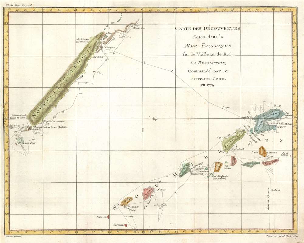
Carte des Découvertes faites dans la Mer Pacifique sur le Vaisseau de Roi, la Resolution, Commandé par the Capitaine Cook en 1774.
1778 (undated) 15 x 18.75 in (38.1 x 47.625 cm) 1 : 2250000
1778 (undated) 15 x 18.75 in (38.1 x 47.625 cm) 1 : 2250000
Description
This is a 1778 Robert Bénard and James Cook map of New Caledonia and Vanuatu. Depicting the islands from the north, the map depicts New Caledonia and the Isle of Pines on the top left and several of the islands in the Vanuatu archipelago, including Espiritu Santo, on the lower right. Discovered during his second voyage, Cook called Vanuatu the New Hebrides, the name that was used until 1980 when the Republic of Vanuatu was established. Cook's route through Vanuatu and around New Caledonia is traced here and there are even references to specific dates where he and his crew landed. Both island groups had been completely unknown to Europeans before Cook's arrival in 1774, although Europeans had 'discovered' Espiritu Santo twice before. A Portuguese explorer sailing for the Spanish Crown landed on the island in 1606, and a French explorer arrived in 1768, but it was Cook's discovery and name that history remembers.
Publication History and Census
This map was created by James Cook and engraved by Robert Bénard for the French edition of Cook's voyages and published in 1778. The OCLC records five examples in institutional collections at the Thomas Fisher Rare Book Library in Toronto, the Alexander Turnbull Library at the National Library of New Zealand, the State Library of Queensland, the State Library of New South Wales, and the National Library of Australia.CartographerS
Robert Bénard (1734 - c. 1785) was a French engraver. Born in Paris, Bénard is best known for supplying a significant number of plates (at least 1,800) for the Encyclopédie published by Diderot and Alembert. He also is remembered for his work with the Académie des Sciences, most notably the Descriptions des Arts et Métiers More by this mapmaker...
Captain James Cook (7 November 1728 - 14 February 1779) is a seminal figure in the history of cartography for which we can offer only a cursory treatment here. Cook began sailing as a teenager in the British Merchant Navy before joining the Royal Navy in 1755. He was posted in America for a time where he worked Samuel Holland, William Bligh, and others in the mapping of the St. Lawrence River and Newfoundland. In 1766 Cook was commissioned to explore the Pacific and given a Captaincy with command of the Endeavour. What followed were three historic voyages of discovery, the highlights of which include the first European contact with eastern Australia, the discovery of the Hawaiian Islands (among many other Polynesian groups), the first circumnavigation of New Zealand, some of the first sightings of Antarctica, the first accurate mapping of the Pacific Northwest, and ultimately his own untimely death at the hands of angry Hawaiians in 1779. The influence of Cook work on the mapping and exploration of the Pacific cannot be understated. Learn More...
Condition
Very good. Even overall toning. Closed tear extending one half inch into printed area from left margin professionally repaired on verso. Blank on verso.
References
OCLC 221414718.