This item has been sold, but you can get on the Waitlist to be notified if another example becomes available, or purchase a digital scan.
1676 John Speed Map of Poland
NeweMapPoland-speed-1676$1,500.00

Title
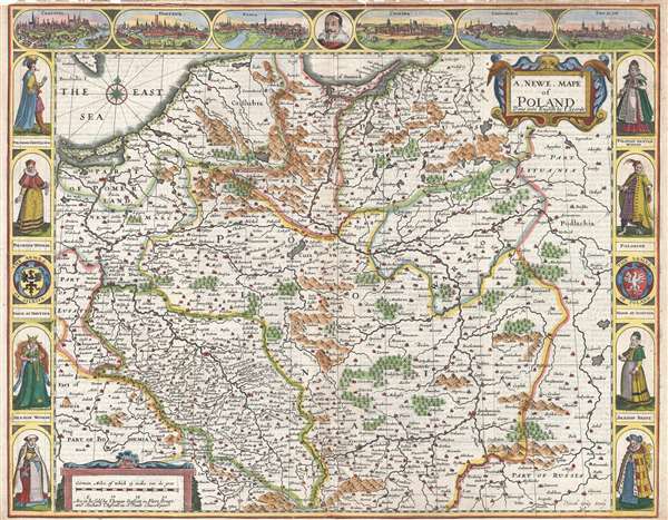
A Newe Mape of Poland.
1676 (undated) 16 x 20.5 in (40.64 x 52.07 cm) 1 : 1840000
1676 (undated) 16 x 20.5 in (40.64 x 52.07 cm) 1 : 1840000
Description
This is a 1676 John Speed carte-a-figure map of Poland issued at the end of the Second Polish-Ottoman War. The map depicts from the Baltic Sea and eastern Bohemia to Prussia, Lithuania, and western Russia and from the Baltic to Kraków (Cracow; Cracovia). Beautifully colored, the region is depicted in detail. Different countries and districts are illustrated and labeled, including Poland, Russia, Prussia, Lithuania, Bohemia, Silesia, and Warzovia (Warsaw). Major cities, such as Warsaw (Warzovia), Kraków (Cracovia), Wrocław (Breslau), and Sandomierz (Sandomiria), along with numerous other towns and villages. Views of Kraków (Cracovia), Gdańsk (Dantzick; Danzig), Poznań (Posna), Krosno Odrzańskie (Crossen), Sandomierz (Sandomiria), and Wrocław (Breslaw; Breslau) are situated along the top border, with a portrait of an unlabeled figure at center. Along the left and right borders, portraits of generalized Polish and Silesian citizens are illustrated. The seals of the armies of Silesia and Poland are also depicted.
This map was produced by John Speed and published by Thomas Bassett and Richard Chiswell in 1676.
This map was produced by John Speed and published by Thomas Bassett and Richard Chiswell in 1676.
CartographerS
John Speed (1542 - 1629) was an important English historian and cartographer active in the early 17th century. Speed was born in Fardon, Cheshire and apprenticed under his father as a tailor. Though his heart was never in tailoring, Speed dedicated himself to this profession until he was about 50 years old. During all the time, Speed dedicated his spare time to research as amateur historian and mapmaker - even preparing several maps for Queen Elizabeth. In London, Speed's interest in history lead him to join the Society of Antiquaries. Eventually he befriended the wealthy Sir Fulke Greville, who sponsored his researches and eventually freed him from the haberdashery profession. Working with William Camden, Speed eventually published his 1611 Historie of Great Britaine. Though this history itself was amateurish and of minimal importance, Speed's inclusion of numerous maps of British Cities and town was seminal. In many cases these plans were the first maps ever issued of their respective subjects. Later, turning his attention more fully to Geography, Speed published the magnificent atlas Theatre of the Empire of Great Britaine and, just prior to his death, the 1627 A Prospect of the Most Famous Parts of the World. These were the first British world atlases and have a landmark position in the history of cartography. These atlases continued to be published well after Speed's death. More by this mapmaker...
Thomas Basset (1637 - 1699) and Richard Chiswell (January 4, 1640 - May 3, 1711), publishing as Basset and Chiswell (1675 - 1676), were English booksellers and map publishers active in the latter half of the 17th century. Though both Basset and Chiswell worked independently, their most significant cartographic accomplishment was their joint purchase of John Speed's map plates, from an enigmatic figure known only as Willoughby, in 1675. Basset and Chiswell, working in concert, added and expanded Speed's Theatre of the Empire of Great Britaine, publishing a new and influential edition of the atlas in 1676. Following the publication of the Theatre the partnership dissolved, the Basset and Chiswell imprint appearing on no subsequent maps, and both went on to separate careers. Basset published several other works and ran a bookstore on Fleet Street, London, until declaring bankruptcy in 1696. He died just a few years later in 1699. Chiswell was somewhat more successful, publishing numerous maps and books well into the 1700s. He was praised and admired by his contemporaries; one of whom, John Dunton, writing in 1705 comments that Chiswell "Well deserves the title of Metropolitan Bookseller of England, if not the whole world. His name at the bottom of a title-page does sufficiently recommend the book. He has not been known to print either a bad book, or on a pad paper". Chiswell died on May 3 of 1711 and is commemorated by a monument, erected by his son and still visible in St. Botolph-without-Aldgate Church. Learn More...
Source
Speed, J. The Theatre of the Empire of Great Britaine. Presenting an Exact Geography of the Kingdomes of England, Scotland, and Ireland and the Isles adjoyning with the Shires Hundreds Citys and the Shire townes within the Kingdome of England devided and described. As asl A Prospect of the most famous Parts of the World. (London: Bassett and Chiswell) 1676.
Condition
Very good. Wear along original centerfold. Margin tears professionally repaired on verso. Some margin chipping not extending into printed map - see image. Tears extending 3/4 inch and 1/2 inch into printed area from top margin professionally repaired on verso. Text on verso.
References
Rumsey 12058.199.