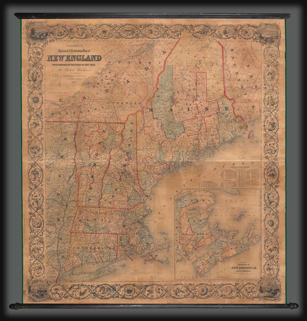
1855 Colton / Hall Wall Map of New England
NewEngland-coltonhall-1855$2,500.00
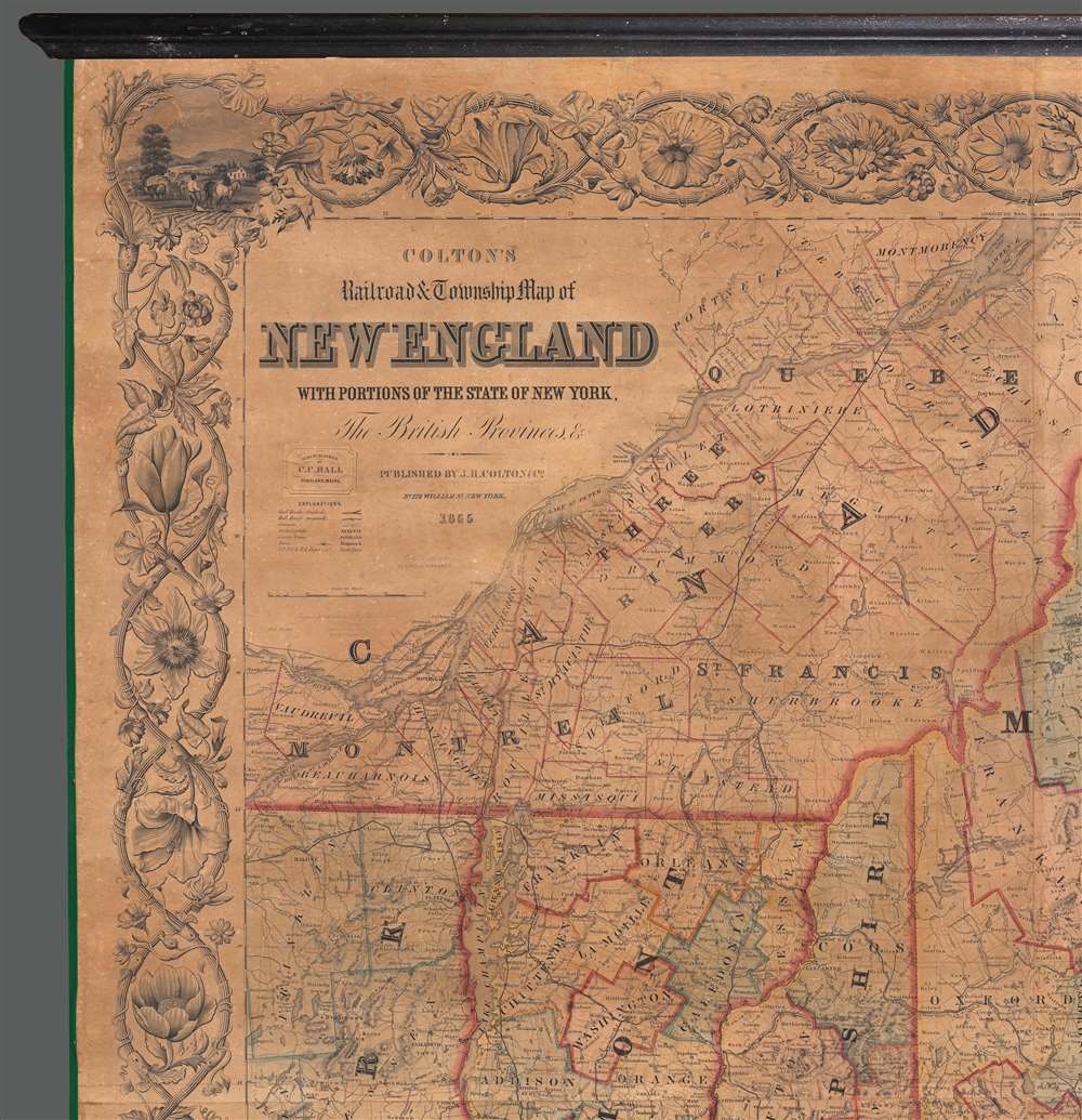


Title
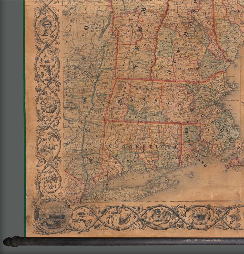
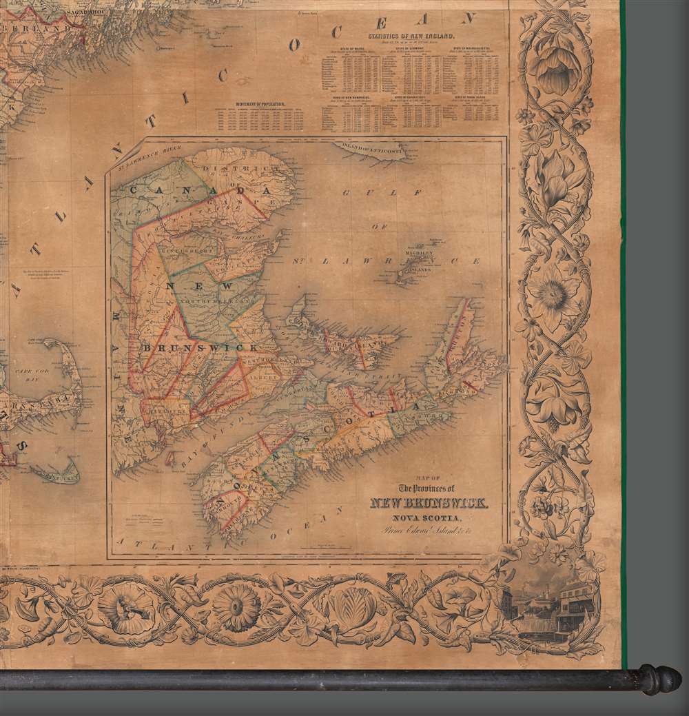
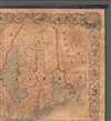
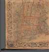
Colton's Railroad and Township Map of New England with Portions of the State of New York, The British Provinces, and co.
1855 (dated) 60 x 56 in (152.4 x 142.24 cm) 1 : 570240
1855 (dated) 60 x 56 in (152.4 x 142.24 cm) 1 : 570240
Description
A large and impressive 1855 wall map of New England published jointly by Joseph H. Colton of New York and Charles C. Hall of Portland, Maine.
A Closer Look
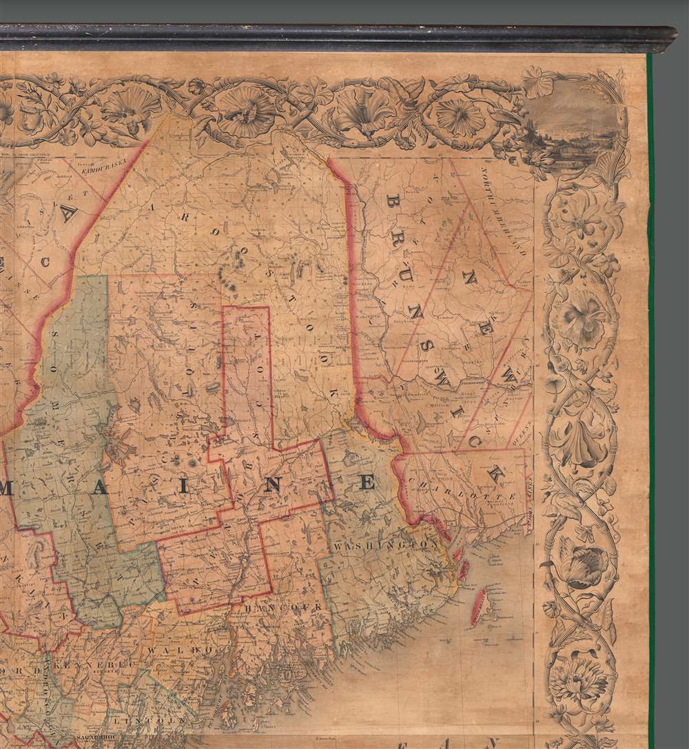
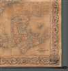
Coverage extends from New York to New Brunswick, embracing all of New England: Connecticut, Massachusetts, Rhode Island, Vermont, New Hampshire, and Maine. The map further includes with excellent detail adjacent parts of New York and Canada. An inset in the lower right details the Canadian Maritimes: New Brunswick, Nova Scotia, and Prince Edward Island. The production is ostensibly a railroad map, illustrating rail networks throughout, detailing tracking, proposed extensions, stations, and naming a dizzying array of independent railroad companies - each operating their own routes.Colton's Engravers
This map is unique in that it lists Colton's engravers who worked on the map in the 1852 - 1855 period - constituting the aesthetic pinnacle of Colton's map publishing career. While much is known of the Colton firm through their copious oeuvre and later legal documentation, little is known their internal workings, especially their engravers. Here, in an uncommon flourish, the engraving team to worked on map are identified: James Picardie Cox (1819 - 1908), F. H. King, I. Devoe, J. H. Goldthwaite, and border engraver William S. Barnard (1809 - ????). It is likely these engravers worked with Colton throughout his most active period from roughly 1845 to 1859, producing without attribution, some of the finest American maps of the 19th century.Publication History and Census
This was compiled and drawn by George W. Colton and published by the J. H. Colton firm in New York. The map first appeared in 1852 with subsequent editions in 1853, 1854, and as here, 1855. The 1855 issued was co-published by the Portland, Maine businessman C. C. Hall - whose pastedown appears below the cartouche to the left. While 1852 - 1853 editions appear in a number of collections, we are aware of only 3 examples of the 1855 - 2 of which bear the C. C. Hall pastedown.Cartographer
Joseph Hutchins Colton (July 5, 1800 - July 29, 1893), often publishing as J. H. Colton, was an important American map and atlas publisher active from 1833 to 1897. Colton's firm arose from humble beginnings when he moved to New York in 1831 and befriended the established engraver, Samuel Stiles. He worked under Stiles as the 'Co.' in Stiles and Co. from 1833 to 1836. Colton quickly recognized an emerging market in railroad maps and immigrant guides. Not a cartographer or engraver himself, Colton's initial business practice mostly involved purchasing the copyrights of other cartographers, most notably David H. Burr, and reissuing them with updated engraving and border work. His first maps, produced in 1833, were based on earlier Burr maps and depicted New York State and New York City. Between 1833 and 1855, Colton proceeded to publish a large corpus of guidebooks and railroad maps, which proved popular. In the early 1850s, Colton brought his two sons, George Woolworth Colton (1827 - 1901) and Charles B. Colton (1832 - 1916), into the map business. G. W. Colton, trained as a cartographer and engraver, was particularly inspired by the idea of creating a large and detailed world atlas to compete with established European firms for the U.S. market. In 1855, G.W. Colton issued volume one of the impressive two-volume Colton's Atlas of the World. Volume two followed a year later. Possibly because of the expense of purchasing a two-volume atlas set, the sales of the Atlas of the World did not meet Colton's expectations, and so, in 1856, the firm also issued the atlas as a single volume. The maps contained in this superb work were all original engravings, and most bear an 1855 copyright. All of the maps were surrounded by an attractive spiral motif border that would become a hallmark of Colton's atlas maps well into the 1880s. In 1857, the slightly smaller Colton's General Atlas replaced the Atlas of the World. Most early editions of the General Atlas published from 1857 to 1859 do not have the trademark Colton spiral border, which was removed to allow the maps to fit into a smaller format volume. Their customers must have missed the border because it was reinstated in 1860 and remained in all subsequent publications of the atlas. There were also darker times ahead; in 1858, Colton was commissioned at a sum of 25,000 USD by the government of Bolivia to produce and deliver 10,000 copies of a large format map of that country. Although Colton completed the contract in good faith, delivering the maps at his own expense, he was never paid by Bolivia, which was at the time in the midst of a series of national revolutions. Colton would spend the remainder of his days fighting with the Bolivian and Peruvian governments over this payment, and in the end, after a congressional intervention, he received as much as 100,000 USD in compensation. Nonetheless, at the time, it was a disastrous blow. J. H. Colton and Company is listed as one of New York's failed companies in the postal record of 1859. This led Colton into the arms of Alvin Jewett Johnson and Ross C. Browning. The 1859 edition of Colton's General Atlas lists Johnson and Browning as the 'Successor's to J. H. Colton' suggesting an outright buyout, but given that both companies continued to publish separately, the reality is likely more complex. Whatever the case may have been, this arrangement gave Johnson and Browning access to many of Colton's map plates and gave birth to Johnson's New Illustrated (Steel Plate) Family Atlas. The Johnson's Atlas was published parallel to Colton's atlases well into the 1880s. The Colton firm itself subsequently published several other atlases including an Atlas of America, the Illustrated Cabinet Atlas, the Octavo Atlas of the Union, and Colton's Quarto Atlas of the World. They also published a large corpus of wall maps, pocket maps, and guides. The last known publications of the Colton firm date to 1897 and include a map and a view, both issued in association with the Merchant's Association of New York. Alice M. Colton married August R. Ohman (May 3, 1859 - April 22, 1934) on January 5, 1897. In 1898, Ohman joined the Colton firm, which continued to publish as Colton, Ohman & Co. until 1901. More by this mapmaker...
James Picardie Cox (May 1, 1819 - April 25, 1908) was an English-American engraver active in New York and Washington D.C. in the mid-19th century. Cox was born in Portsea, England. He emigrated to New York in 1838 and naturalized in 1852. He worked in New York for the J. H. Colton firm in the 1850s, was briefly independent, and around 1870 moved Washington D.C. to work for the U.S. Coast Survey, and later in the1880s for the U.S. Coast and Geodetic Survey. Learn More...
Condition
Very good. Full professional restoration. Accompanies original rollers, but detached (can be reattached on request). Measurement reflects printed map, not rollers.
References
Library of Congress, G3721.P3 1852 .C6. Library of Congress, Railroad maps, #107. Modelski 107. Phillips p. 473.