1954 Ford Dealers of New England Pictorial Map of New England
NewEnglandJourneys-ford-1954$250.00


Title
New England Journeys.
1954 (undated) 33.5 x 24 in (85.09 x 60.96 cm) 1 : 930000
1954 (undated) 33.5 x 24 in (85.09 x 60.96 cm) 1 : 930000
Description
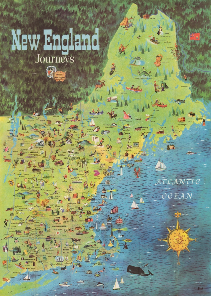
This is a 1954 pictorial map of New England published by the Ford Dealers of New England. The piece uses the scenic beauty and historical attractions of New England to capitalize on a new era of mobility that defined American Automobile Craze - and in fact, the rise of auto-tourism in the Untied States directly correlates with the Federal-Aid Highway Act of 1956, just two years after this piece was issued.
A Closer Look
Depicting from Maine to Long Island, pictorial vignettes highlight attractions, museums, and other sites of touristic interest. Universities, art museums, statues, and historic homes appear alongside zoos, the Maple Sugar Center in St. Johnsbury, beaches, and Acadia National Park.Verso Content
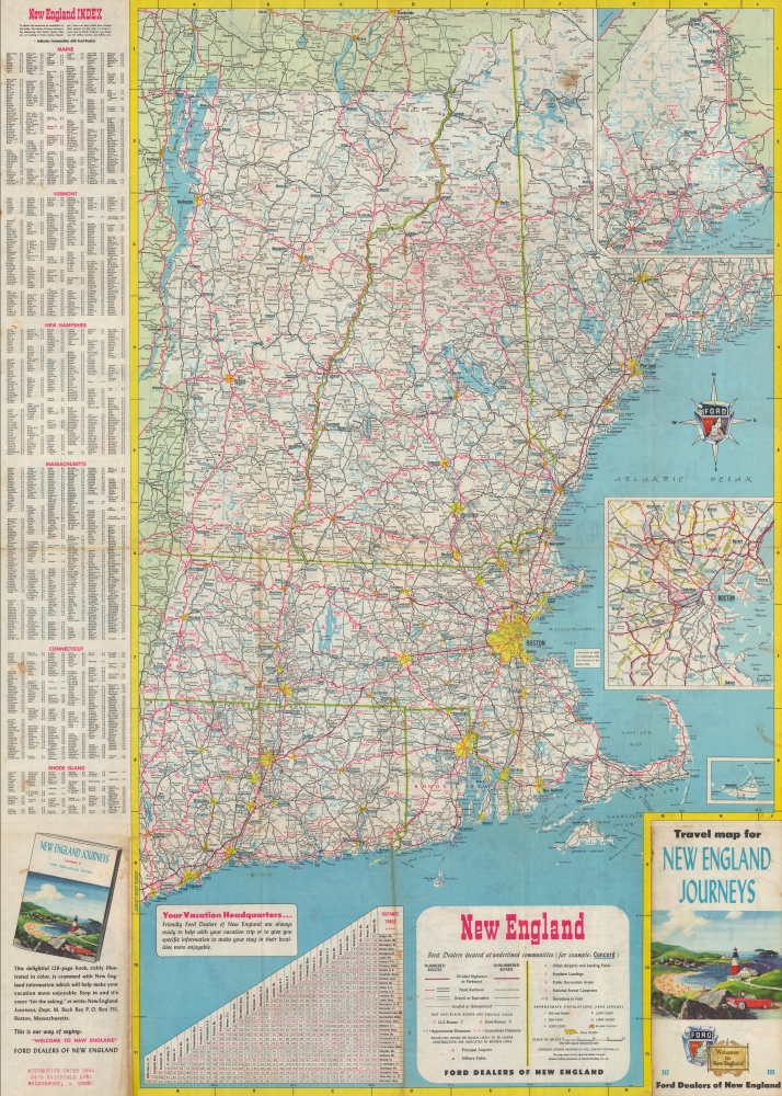
A road map of New England occupies the verso. Yellow spots mark major cities, while red and black roads snake their way throughout. A distance table appears along the bottom border and a town index divided by state is situated outside the left border.Publication History and Census
This map was drawn by an artist known only by the last name 'Berss 'and published by the Ford Dealers of New England in 1954. Unfortunately, decades of General Drafting Company maps of New England have been populated throughout OCLC, making it impossible to trace how many examples of each specific map survive.Cartographer
General Drafting Corporation (1909 - 1992) was one of the 'Big Three' publishers of road maps between 1930 and 1970, along with H. M. Gousha and Rand McNally. Founded in 1909, Otto G. Lindberg, an immigrant from Finland and the company's founder, began his business with a borrowed drafting board and a $500 loan from his father. At the time only twenty-three years old, Lindberg advertised his business as 'any and all general drafting' and was based out of 170 Broadway in New York City. Only two years later, in 1911, the firm secured its first contract from the American Automobile Association to make 'road maps'. Lindberg incorporated his business in 1914 and became its first Chairman of the Board, a position he held until his death in 1968. Lindberg persuaded Standard Oil of New Jersey to let him draw the 'best' road map of the state that they had ever seen, and Standard Oil would distribute it for free. Sufficiently impressed with the finished product, Standard contracted General Drafting to make all their road maps - a relationship that lasted another six decades. This relationship allowed General Drafting to work exclusively for Standard Oil, but when oil companies stopped providing free maps, General Drafting was in a bind. The company tried to expand into the retail map market, and it of course continued creating maps for Exxon (the new name for Standard Oil) to sell, but its returns continued to decline. The firm was purchased in 1992 by Langenscheidt and subsequently absorbed into the American Map Company. General Drafting's state maps became this company's 'Travelvision' lineup. More by this mapmaker...
Condition
Very good. Verso repairs to two fold separations. Road map of New England on verso.
References
OCLC 39113290.