This item has been sold, but you can get on the Waitlist to be notified if another example becomes available, or purchase a digital scan.
1729 Moll Map of New York, New England, and Pennsylvania (First Postal Map of New England)
NewEnglandNewYork-moll-1729$400.00

Title
New England, New York, New Jersey and Pensilvania.
1729 (undated) 8.5 x 11 in (21.59 x 27.94 cm)
1729 (undated) 8.5 x 11 in (21.59 x 27.94 cm)
Description
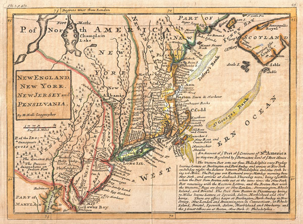
Known among cartographic historic as the 'Post Map,' this is Herman Moll's important 1729 map of New England and the adjacent colonies. Though variants of this map appear as early as 1708, this is the most important of the series due to its thematic focus on the New England, New York, New Jersey Pennsylvania postal system.
Official postal service emerged in the New England colonies around 1639 when the Massachusetts General Court designated a Boston tavern as the official repository for mail arriving from or departing overseas. In 1673 official postal service between New York and Boston was introduced on a monthly basis but it was not until 1691, with the appointment of a Postmaster General to the colonies, that a centralized postal system evolved. The first post route in the Colonies, between New York and Boston, became known as the Boston Post Road and is today still in use as U.S. Route 1.
Moll describes this route in some detail in the lower right quadrant of the map:
Though Barbara McCorkle reports that this map was published in a number of different atlases and histories, this is an early example from the 1729 first edition of Moll's Atlas Minor.
Official postal service emerged in the New England colonies around 1639 when the Massachusetts General Court designated a Boston tavern as the official repository for mail arriving from or departing overseas. In 1673 official postal service between New York and Boston was introduced on a monthly basis but it was not until 1691, with the appointment of a Postmaster General to the colonies, that a centralized postal system evolved. The first post route in the Colonies, between New York and Boston, became known as the Boston Post Road and is today still in use as U.S. Route 1.
Moll describes this route in some detail in the lower right quadrant of the map:
The Western Post setts out from Philadelphia every Fryday leaving Letters at Burlington and Pert Amboy and arrives at New York on Sunday night; the distance between Philadelphia and New York being 106 Miles. The Post goes out Eastward every Monday morning from New York, and arrives at Seabrook Thursday noon; being 150 Miles, where the Post from Boston setts out at the same time; the New York Post returning with the Eastern Letters, and the Boston Post with the Western, Bags are dropt at New London, Stommington, Rhode Island, and Bristol. The Post from Boston to Piscataway being 70 Miles leaves Letters at Ipswich, Salem, Marblehead, and New : berry. There are office keept at Burlington, Perth Amboy in New Jersey, New London and Stommington in Connecticott, at Rhode Island, Bristol, Ipswich, Salem, Marblehead, and Newberry, and the 3 Great Offices are at Boston, New York & Philadelphia.In addition to this maps core details regarding the postal system in America, it also offers additional information on the region including American Indian villages and nations on the west side of the Susquehanna, countless towns and villages, some offshore shoals, and a gross mismapping of Lake Champlain. New Jersey is split into East New Jersey and West New Jersey – an archaic distinction dating to a 28 year period between 1674 and 1702. Delaware is conjoined with Pennsylvania.
Though Barbara McCorkle reports that this map was published in a number of different atlases and histories, this is an early example from the 1729 first edition of Moll's Atlas Minor.
CartographerS
Herman Moll (1654 - 1732) was an important 18th century map publisher and engraver based in London and Holland. Moll's origins are disputed with some suggesting he was born in the Netherlands and others Germany - the Moll name was common in both countries during this period. Most likely Moll was a German from Bremen, as his will, friends, and contemporaries suggest. What is known for certain is that he moved to London in 1678, possibly fleeing the Scanian War, where he worked as an engraver for Moses Pitt and other London map publishers. Around the turn of the century, Moll set up his own shop where he produced a large corpus of work known for its high quality and decorative flair. As a new émigré to England, Moll made himself more English than the English, and through his cartography proved a fierce advocate for his adopted nation. Most of Moll's early maps were issued as loose sheets that would be bound to order, however, he did publish several important atlases late in his career. Moll is said to have made the bold claim that without a doubt "California is an Island" and that he "had in [his] office mariners who have sailed round it." While California may not be an island (yet), it is true that moll had talent for attracting interesting friends and acquaintances. He frequented London's first stock exchange, Jonathan's Coffeehouse at Number 20 Exchange Alley, Cornhill. At the time Jonathan's was known as "a place of very considerable concourse for Merchants, sea faring Men and other traders" (Erleigh, The Viscount, The South Sea Bubble, Manchester: Peter Davies, Ltd., 1933, 21). Eventually this activity attracted the interest of stock brokers, who inspired by sailor's tales, sponsored the ill-fated South Sea Company, the world's first stock bubble. Moll's close circle, mostly from the Coffee House, included scientist Robert Hooke, the writers Daniel Defoe (Robinson Crusoe) and Jonathan Swift (Gulliver's Travels), the pirates William Dampier, William Hacke and Woodes Rogers, and the archeologist William Stukeley. Herman Moll's work was highly regarded for its decorative beauty and was pirated, most notably by the Irish publisher George Grierson, both in his lifetime and after his 1732 death at St. Clement Danes, London. More by this mapmaker...
The Bowles Family (fl. c. 1714 - 1832) were publishers and map sellers active in London from c. 1714 to c. 1832. The firm, under Thomas Bowles (fl. 1714 - 1763), John Bowles (1701 - 1779), Carrington Bowles (1724 - 1793), and as Bowles and Carver (fl. 1794 - 1832), produced a massive corpus of work that included numerous atlases, pocket maps, and wall maps. The Bowles publishing tradition was kept alive for four generations, starting with Thomas Bowles, a print engraver active in the late 17th century. His son, Thomas Bowles II, produced the firm's first maps at St. Paul's Churchyard, London. Thomas's brother, John Bowles (a.k.a. 'Old John Bowles' or 'Black Horse Bowles'), was also an active publisher established at no. 13 Cornhill. He is credited as one of the first publishers of William Hogarth's works. There, John's son, Carrington Bowles, was introduced to the trade. Carrington took over the Cornhill bookshop and eventually merged it with his uncle's shop in St. Paul's Churchyard. On Carrington's 1793 death, the business was passed to his son Henry Carrington Bowles (1763 - 1830), who partnered with his father's former apprentice Samuel Carver (1756 - 1841), renaming the firm 'Bowles and Carver'. Under this imprint, the firm continued to publish maps and atlases until 1832. Henry Carrington Bowles died in 1830, but Samuel Carver, himself in advanced years and poor health, kept it going for another 2 years before closing the business. Learn More...
Source
Moll, H., Atlas minor: or a new and curious set of sixty-two maps, in which are shewn all the empires, kingdoms, countries, states, in all the known parts of the earth; with their bounds, divisions, chief cities & towns, the whole composed & laid down agreable to modern history. By Herman Moll, Geographer, (Thos. and John Bowles, London) 1729.
Condition
Very good. Even overall toning. Blank on verso.
References
Rumsey 5580.049. Phillips (America) p. 500. McCorkle B., New England in Early Printed Maps 1513-1800, 729.2. New York Public Library, Map Division, Map Div. 01-5120.