
This item below is out of stock, but another example (left) is available. To view the available item, click "Details."
Details
1846 Bradford Map of New Hampshire
1846 (dated) $350.00
1842 Bradford Map of New Hampshire
NewHampshire-bradford-1842$150.00

Title
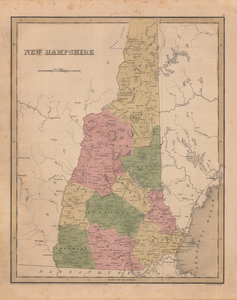
New Hampshire.
1842 (undated) 14.25 x 11.5 in (36.195 x 29.21 cm) 1 : 830000
1842 (undated) 14.25 x 11.5 in (36.195 x 29.21 cm) 1 : 830000
Description
An appealing and scarce 1842 map of New Hampshire, produced by Thomas Bradford and Samuel Goodrich for their Illustrated Atlas. As is prevalent among many maps in Bradford's atlas, the state's nascent rail network is highlighted.
Eventually, the railroads won out, but aside from political opposition, financial and logistical difficulties slowed progress. Of the lines seen here, the Boston and Maine Railroad line to Dover was the only one complete at the time of publication, reaching Exeter in 1840 and Dover in 1842. The Eastern Railroad through Portsmouth to Portland, Maine was not completed until 1843, while the Concord Railroad (also a Boston and Maine project) took much longer to complete, only beginning operations in 1850.
A Closer Look
Highly detailed, the map shades each county a different color to allow for easy differentiation. Numerous cities and towns are labeled, as are rivers, lakes, and other physical features, including Mount Washington, the highest peak in the northeastern United States. Several now-unconventional spellings appear, such as ' Winnipiseogee Lake,' 'Whitefields,' and 'Brettonwoods.' The Dartmouth College grant in the northern part of the state, the 'Society Land' next to the town of Antrim (a relic of the colonial era), and ungranted land near 'Crawford's' Notch and Millsfield in the far northern part of the state are all noteworthy, as is the disputed territory in the northern portion of the state.The Republic of Indian Stream
Territorial disputes between the United States and Great Britain are referred to at top, as the boundary claimed by Great Britain is indicated considerably to the south of that claimed by the U.S. The disagreement stemmed from ambiguous language in the 1783 Treaty of Paris, which ended the American Revolution. Local residents, who considered themselves citizens of the U.S. but not of New Hampshire, were so annoyed by the dispute that they declared an independent republic, the Republic of Indian Stream (named after the local waterway marked 'Indians R.' here), in 1832. Three years later, the sheriff of Coos County, New Hampshire called up militia units and forcibly annexed the republic. Both the British government and some local residents were highly dissatisfied with this action and continued to contest the area's status as part of New Hampshire. Eventually, local residents accepted their fate as New Hampshirites; the town of Pittsburg was incorporated in 1840 (not reflected here), which remains the largest town by area in New England, and the territorial dispute was formally resolved with the 1842 Webster-Ashburton Treaty.Railroads in New Hampshire in the 1830s and 1840s
During the 1830s and 1840s, there was a significant push to build railroads from Boston across New Hampshire and Vermont to Lake Champlain, because New York State was no longer issuing charters to out-of-state railroad companies that might compete with the Erie Canal. Thus, by building railways through New Hampshire and Vermont, New York could be mostly avoided. Efforts were also underway to extend Massachusetts' rail network along the coast to Portland, Maine. Alas, as with all major undertakings, there was plenty of political pressure against the creation of railroad lines in New Hampshire from coach companies and other interests.Eventually, the railroads won out, but aside from political opposition, financial and logistical difficulties slowed progress. Of the lines seen here, the Boston and Maine Railroad line to Dover was the only one complete at the time of publication, reaching Exeter in 1840 and Dover in 1842. The Eastern Railroad through Portsmouth to Portland, Maine was not completed until 1843, while the Concord Railroad (also a Boston and Maine project) took much longer to complete, only beginning operations in 1850.
Publication History and Census
This map was prepared by Thomas Bradford and engraved by George Washington Boynton. It appeared in the 1842 edition of Samuel Goodrich's reprint of Bradford's Universal Illustrated Atlas. Though dated 1838, some details (including the page number at top-right, text offsetting from an opposite page, and rail lines present) distinguish it from Bradford's map of New Hampshire published in the first edition of his General Atlas, as well as the 1841 Goodrich reprint (held by the David Rumsey Historical Map Collection) and the New Hampshire map that appeared in the 1846 edition of Bradford's Universal Illustrated Atlas (previously sold by us). The present state is quite rare, having no known history in institutional collections or on the market, though that is likely because extant examples are understandably yet incorrectly dated to 1838.CartographerS
Thomas Gamaliel Bradford (1802 - 1887) was born in Boston, Massachusetts, where he worked as an assistant editor for the Encyclopedia Americana. Bradford's first major cartographic work was his revision and subsequent republishing of an important French geography by Adrian Balbi, Abrege de Geographie published in America as Atlas Designed to Illustrate the Abridgment of Universal Geography, Modern and Ancient. Afterwards Bradford revised and expanded this work into his own important contributions to American cartography, the 1838 An Illustrated Atlas Geographical, Statistical and Historical of the United States and Adjacent Countries. Bradford's cartographic work is significant as among the first to record Texas as an independent nation. In his long career as a map publisher Bradford worked with William Davis Ticknor of Boston, Freeman Hunt of New York, Charles De Silver of Philadelphia, John Hinton, George Washington Boynton, and others. We have been able to discover little of Bradford's personal life. More by this mapmaker...
George Washington Boynton (fl. c. 1830 - 1850) was a Boston based cartographer and map engraver active in the first half of the 19th century. Boynton engraved and compiled maps for numerous publishers including Thomas Bradford, Nathaniel Dearborn, Daniel Adams, and S. G. Goodrich. His most significant work is most likely his engraving of various maps for Bradford's Illustrated Atlas, Geographical, Statistical, and Historical, of the United States and the Adjacent Countries and Universal Illustrated Atlas. He also engraved for the Boston Almanac. In 1835, Boynton is listed as an employee of the Boston Bewick Company, an engraving, stereotype, and printing concern based at no. 47 Court Street, Boston. Little else is known of his life. Learn More...
Source
Bradford, T. G. and Goodrich, S. G., A Universal Illustrated Atlas, exhibiting a Geographical, Statistical, and Historical view of the World, (Boston: Charles D. Strong) 1842.
The Universal Illustrated Atlas is one of the great American atlases of the first half of the 19th century. The atlas was first published in 1838 under the imprint of Charles D. Strong. It replaced and superseded Bradford's earlier smaller format Illustrated Atlas, Geographical, Statistical, and Historical, of the United States and the Adjacent Countries. Numerous reissues of the Universal Illustrated Atlas followed until about 1848. Although there are minor variations between the editions, most contain about 50 maps, the majority of which focus on the United States. Bradford's atlases are significant for recording North America during the Republic of Texas Era. In later editions, particularly the 1846 edition, Bradford illustrates the boom in railroad construction, possibly with the idea that his maps would aid travelers in planning journeys by rail. It was compiled by Thomas Gamaliel Bradford and Samuel Griswold Goodrich with most of the plates engraved by George Washington Boynton (fl. c. 1830 - 1850). Other contributors include Thomas Gordon (1778 - 1848), Fielding Lucas Jr. (1781 - 1854), Samuel Edward Stiles (1844 - 1901), Sherman and Smith (fl. c. 1829 - 1855), and Horace Thayer (1811 - c. 1874).
Condition
Good. Even toning. Light foxing. Some offsetting present.
References
Rumsey 4453.009 (1841 edition).