This item has been sold, but you can get on the Waitlist to be notified if another example becomes available, or purchase a digital scan.
1928 Mortimer Pictorial City Map or Plan of New Haven, Connecticut
NewHaven-mortimer-1928-2$250.00

Title
New Haven.
1928 (dated) 27.5 x 35.5 in (69.85 x 90.17 cm) 1 : 24000
1928 (dated) 27.5 x 35.5 in (69.85 x 90.17 cm) 1 : 24000
Description
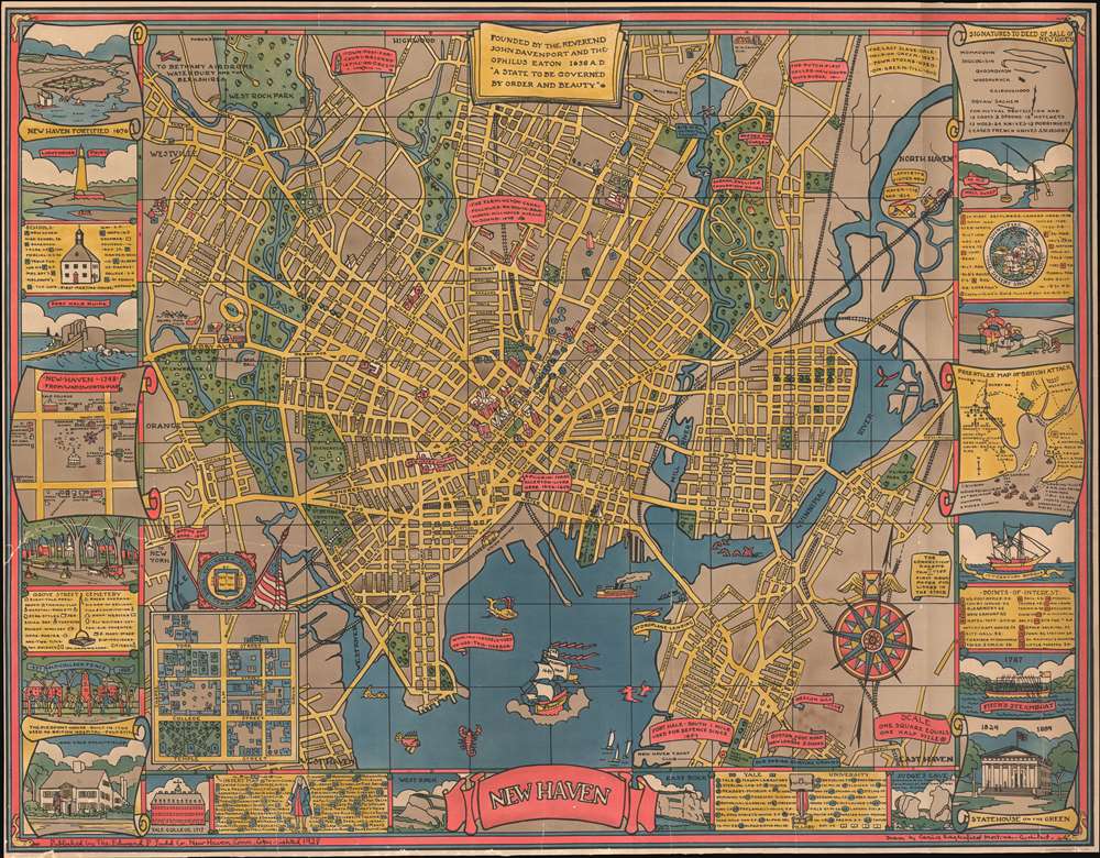
This is a 1928 Carina Eaglesfield Mortimer pictorial city map or plan of New Haven, Connecticut. The map depicts the city from Westville and Orange to the Quinnipiac River, North Haven, and Fairmont Park and from West Rock Park to Fort Wooster Park.
Yale
Mortimer's map focuses significance of Yale University to New Haven's identity. Twenty-nine campus buildings are identified numerically, corresponding to an index situated along the bottom border. The Yale University Coat of Arms is included in the lower left above an inset map of the campus.Other Sites
Other historic sites are labeled through text boxes, such as the site of Eli Whitney's gun factory, the home of a pilgrim, and the Boston Post Road to New York. An inset map, situated on the lower left, depicts central New Haven from between Park Street and York Street to Temp Street and from Chapel Street to Grove Street. Fifty-seven different buildings are numerically labeled and correspond to an index directly below the inset map.Border Work
A border consisting of various vignettes, indexes, and small maps encircles the central map on three sides. Some of the illustrations include vignettes of a fortified New Haven, lighthouse point, the ruins of Fort Hale, the Pierpont House, West Rock, East Rock, the Statehouse on the Green, Fitch's Steamboat, and an old well sweep. Two inset maps detail New Haven in 1748 and Pres. Stiles' Map of the British Attack.Publication History and Census
This map was drawn by Carina Eaglesfield Mortimer and published in 1928 by the Edward P. Judd Company of New Haven, Connecticut. It was printed by the American Lithographic Company.CartographerS
Carina Eaglesfield Mortimer Milligan (March 19, 1890 - September 12, 1978) was an American architect. Born in Indianapolis, Indiana to James Theophilius Eaglesfield and Caroline Buckley Campbell, Milligan attended Sweet Briar College and the Cambridge School of Domestic Architecture. She designed houses, which were advertised in local newspapers. After the outbreak of World War II, Milligan worked with Miss Anne Morgan in the Comite American de Secour Civil in France. She married Ernest Mortimer in 1923, who died in 1937, and John Raymond Milligan in 1941, who died in 1959. More by this mapmaker...
The American Lithographic Company (1892 - 1929) was a New York City printing concern active in the late 19th and early 20th centuries. It is considered the first American printing conglomerate. American Lithographic was formed when Joseph Palmer Knapp (1864 - 1951) of the publishing houses Sarony, Major, and Knapp, Major and Knapp, and Knapp and Company, launched a bold plan to consolidate American lithographic printing under one brand. Leveraging his enormous inherited wealth (is father, Joseph Fairchild Knapp (1832 - 1891), was the major shareholder in the Metropolitan Insurance Company), Palmer Knapp consolidated multiple smaller presses, including George S. Harris and Sons, Heppenheimer's and Sons, the Donaldson Brothers Company, the Giles Company, Eddy and Calaus, Witsch and Schmitt, and Schumacher and Ettinger. The consolidation was a hedge to control the lucrative cigar label printing industry. By 1890, prices for color lithography had fallen below sustainable levels due to both the high expense of producing multiple separate stones (one for each color) and favorable manufacturer terms on the purchase of lithographic equipment. This created a highly competitive market, pushing printing prices below cost and driving many smaller companies out of business. By consolidating American lithographic presses under one brand, Knapp hoped to restore industry stability. Initially, the many companies that entered the American Lithographic Company continued to work separately, but by 1900, Knapp centralized production in one large New York City facility. The American Lithographic Company became a major force in American printing, controlling about 75% of the American market for printed graphics. The firm began to decline in the early 20th century when cheaper halftone photographic processes rose to dominate the market. At the same time, demand for fruit and cigar labels, the mainstay of American Lithographic, began to decline. In 1929, the firm was sold to the United States Printing and Lithographic Company, which in 1930 liquidated the cigar label business to Consolidated Lithographing. Learn More...
Condition
Average. Several large cracks and tears have been stabilized with a linen backing. Priced accordingly.
References
Rumsey 7916.000. New Haven Museum Whitney Library, G3784.N4M676 1928. OCLC 668395148.