This item has been sold, but you can get on the Waitlist to be notified if another example becomes available, or purchase a digital scan.
1777 First Edition Ratzer / Faden Map of New Jersey - Provenance to Revolutionary War!
NewJersey-ratzer-1777$6,000.00

Title
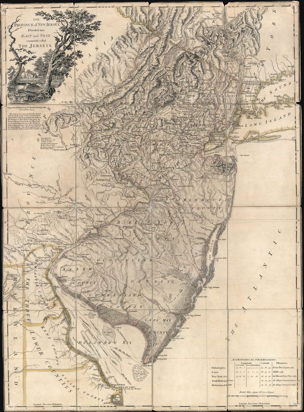
The Province of New Jersey Divided into East and West, commonly called The Jerseys.
1777 (dated) 30.75 x 22.75 in (78.105 x 57.785 cm) 1 : 430000
1777 (dated) 30.75 x 22.75 in (78.105 x 57.785 cm) 1 : 430000
Description
A most fascinating 1777 first-state first-edition map of New Jersey by William Faden and Bernard Ratzer likely used in the field during the American Revolutionary War by the German Hessian supply officer, Friedrich Wilhelm von Wurmb. While focused on New Jersey, coverage extends to include eastern Pennsylvania, Delaware, and New York City. It captures the state's complex topography, noting the Jersey Highlands and the Palisades in the north and the Pine Barrens and coastal marshes in the south. New Jersey is here broken down into 12 counties, as they existed at the time, as well as multiple towns and roads. Note that there are no coastal routes through Monmouth County, requiring travelers instead to travel inland to Crosswicks, then south east to Egg Harbor, before continuing south. There is also an annotation regarding the settlement of Fort Helsingburg, near Salem on the Delaware River, where in 1640, Swedish settlers attempt to establish a colony.
Two other significant boundary lines are indicated, dividing the state on a rough north-south axis. These are 'Keith's Line in 1687', surveyed by George Keith (c. 1639 - 1716), surveyor general of East Jersey; and the 'Division Line Run in 1743 between East New jersey and West New Jersey', surveyed by John Lawrence (1709 - 1794) and generally known as either the 'Quintipartite Line' or 'Lawrence Line'. This latter line was run by corporation of five Quaker partners, among the William Penn, who acquired Lord Berkeley's properties in New Jersey in 1676 and is still used today to resolve boundary and property disputes.
Copies of the documents that Ratzer submitted to the Commission in 1769 survive at Harvard and present a far simpler map, that while geometrically accurate, lacks roads, most cities, and other details. We are also aware of more detailed Ratzer maps surviving in manuscript in British collections, suggesting that there may be a more detailed map of New Jersey by Ratzer's hand that is now lost.
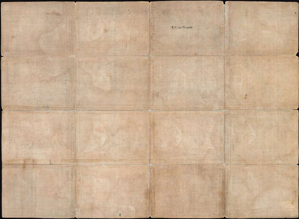
Friedrich Wilhelm von Wurmb
The stamp on the verso identifies the original owner of this map as Friedrich Wilhelm von Wurmb (June 14, 1744 - September 18, 1827), providing provenance as well as a glimpse of its original use and purpose. Wurmb, during the American Revolutionary War, was a Colonel Hessian Leib Infantry in the 2nd Division under General von Knyphausen. The British contracted more than 30,000 Hessian mercenaries to help suppress the Rebels. In mid-June 1778, Wurmb's division was responsible for transporting the British army's massive baggage train in an overland march across central New Jersey from Philadelphia to New York. As the largest and most detailed map of New Jersey available at the time, we can assume with some confidence that this is the map he used for that critical mission.The Ratzer Surveys
The underlying surveys for this map were completed in 1769 by Bernard Ratzer, a German military surveyor in the British New American Regiment famous for his two large Revolutionary War Era maps of New York City. Following the French and Indian War he was appointed by King George III's New York-New Jersey Boundary Commission to resolve the long-disputed boundary between the two colonial provinces. Samuel Holland and William De Brahm, the Commission heads, agreed on the boundary in 1764, but it was not properly surveyed until Ratzer completed his assignment in 1769. Accordingly, the 'Boundary as settled by the Commissioners in 1759' runs from the conjunction of the Delaware and the Mahacamack (Neversink) River to a point on the Hudson River marked as 'Rockland', roughly corresponding to modern day 'Rockleigh'.Two other significant boundary lines are indicated, dividing the state on a rough north-south axis. These are 'Keith's Line in 1687', surveyed by George Keith (c. 1639 - 1716), surveyor general of East Jersey; and the 'Division Line Run in 1743 between East New jersey and West New Jersey', surveyed by John Lawrence (1709 - 1794) and generally known as either the 'Quintipartite Line' or 'Lawrence Line'. This latter line was run by corporation of five Quaker partners, among the William Penn, who acquired Lord Berkeley's properties in New Jersey in 1676 and is still used today to resolve boundary and property disputes.
Copies of the documents that Ratzer submitted to the Commission in 1769 survive at Harvard and present a far simpler map, that while geometrically accurate, lacks roads, most cities, and other details. We are also aware of more detailed Ratzer maps surviving in manuscript in British collections, suggesting that there may be a more detailed map of New Jersey by Ratzer's hand that is now lost.
Gerard Bancker
Although Faden primarily compiled the map based upon the work of Ratzer, for the northern parts of New Jersey, he turned to surveys completed by Gerard Bancker (February 14, 1740 - January 1799). Bancker was descended from early Dutch settlers, including Johanns de Peyster (1666 - 1719), the 23rd Mayor of New York City. He worked as City Surveyor of New York in the late 18th century, but no record survives of his work in New Jersey - which we can only assume was extensive although never published. Faden acquired Bancker's surveys from John Murray, the Earl of Dunmore and former governor of Virginia, who collected a manuscript copy while traveling in New York. That manuscript is unfortunately not known to have survived.Publication History and Census
This map was originally published, as here, in London in 1777 by William Faden. There are three known states: this, the first state bearing the imprint 'Wm. Faden, Dec. 1st 1777'; a second state issued in 1778 with the imprint 'Second Edition with considerable improvements'; and a third state issued in 1794, identical to the second, but printed on 'J. Whatman 1794' woven paper. The map was issued both separately, as here, and in Faden's landmark 1777 work, The North American Atlas. Due to its publication in the popular Faden atlas, this map is well represented in institutional collections. Such examples are usually identifiable by manuscript page numbers and fold metric. Separate issue examples, as here, are far rarer and the unique provenance evident here, tracing the map to field action during the war, make this piece unique.CartographerS
Bernard Ratzer (aka Bernhard, aka Ratzen) (fl. 1756 - 1782) was an important military engineer, cartographer, and surveyor active in the mid to late 18th century. While he is often referred to as 'British', Ratzer was most certainly German. Nothing is known of Ratzer's youth. He first appears on February 20, 1756, when he is identified as one of the German officers recruited under the Commissions to Foreign Protestants Act 1756 (29 Geo. 2 c. 5) as a Lieutenant in the First Battalion of the British Royal American Regiment. The Regiment was raised to compensate for British troop shortages during French and Indian War (1754 - 1763). The Act called for engineers and officers to be German-speaking so they could effectively command the all-Germanic regiment. According to the mandate, in addition to regulars, there would be 50 officers and 20 engineers, none of which would be allowed to advance beyond the rank of lieutenant-colonel. Many of the officers and engineers, likely including Ratzer, were recruited in Europe by the swiss Engineer James Prévost. He must have already had extensive engineering training, as he was immediately assigned to work under the Dutch surveyor Samuel Holland as a lieutenant in military engineer's division. Most of his earliest survey work survives only in manuscript form, and is related to the activities of the Royal Americans. Ratzer's first recorded map, created when he was an ensign, details Maine's Passamaquoddy Bay (1756). He also completed several smaller surveys of French and Indian War forts around Lake Ontario and on the Niagara River. After the war, Ratzer was one of the 1500 victorious British troops that arrived in New York. The New York Governor Henry Moore assigned him the task of improving upon the critically flawed John Montresor map of 1767. This resulted in Ratzer's two most important maps, the 'Ratzen Plan' (1767) and the much larger 'Ratzer Map' (1776), both considered to be among the finest maps of any American city issued during the 18th century. Between surveying the 'Ratzen Plan' and the larger 'Ratzer Map,' Ratzer was next assigned to work with Samuel Holland on the New York - New Jersey Border Line Survey producing an important manuscript map in 1769, now in the Harvard University Collections. This survey work was published by William Faden in 1777, during the American Revolutionary War, as 'The Jerseys.' Due to the engraver Thomas Kitchin's misspelling of his name on the title of the 1767 Plan of the City of New York, also known as the 'Ratzen Plan,' Ratzer's name is often confused as 'Ratzen.' Ratzer must have found military life to his liking, as he remained in the British Army, achieving the rank of Captain in 1773, and Major in 1782. More by this mapmaker...
William Faden (July 11, 1749 - March 21, 1836) was a Scottish cartographer and map publisher of the late 18th century. Faden was born in London. His father, William MacFaden, was a well-known London printer and publisher of The Literary Magazine. During the Jacobite Rebellion (1745 - 1746), MacFaden changed his family name to Faden, to avoid anti-Scottish sentiment. Faden apprenticed under the engraver James Wigley (1700 - 1782), attaining his freedom in 1771 - in the same year that Thomas Jefferys Sr. died. While Thomas Jefferys Sr. was an important and masterful mapmaker, he was a terrible businessman, and his son, Jefferys Jr., had little interest in building on his father's legacy. MacFaden, perhaps recognizing an opportunity, purchased his son a partnership in the Jefferys firm, which subsequently traded as 'Faden and Jefferys'. Jefferys Jr. also inherited Jefferys Sr.'s title, 'Geographer to the King and to the Prince of Wales'. With little interest in cartography or map publishing, Jefferys Jr. increasingly took a back seat to Faden, and by 1776, he had withdrawn from day-to-day management, although he retained his financial stake. The American Revolutionary War (1775 - 1783) proved to be a boom for the young 'Geographer to the King', who leveraged existing materials and unpublished manuscript maps to which he had access via his official appointment to publish a wealth of important maps, both for official use and the curious public - this period of prosperity laid the financial underpinning for Faden, who by 1783, at the end of the war, acquired full ownership of the firm and removed the Jefferys imprint. In 1801, he engraved and published the first maps for the British Ordnance Survey. By 1822, Faden published over 350 maps, atlases, and military plans. He retired in 1823, selling his plates to James Wyld Sr. Faden died in 1836. Learn More...
Condition
Average. Map is dissected and mounted on original linen, which bears the original owner's personal stamp. Old color. SOme edge wear, especially along old folds. Some of the old linen backing is worn and split here and there on fold lines. Could be reinforced, we have avoided all restoration given the map's significant provenance.
References
OCLC 5400894. Library of Congress, Maps of North America, 1750-1789, #1240. Stevens, H. and Tree, R., 'Comparative Cartography', in Tooley, R. V., The Mapping of America, #37(a), page 73. Delaney, J., Nova Caesarea: A Cartographic Record fo the Garden State 1666 -1888, pages 33 - 38.