This item has been sold, but you can get on the Waitlist to be notified if another example becomes available, or purchase a digital scan.
1862 John Pope Map of the Mississippi River around New Madrid, Missouri
NewMadridIsland102-wardept-1862$225.00

Title
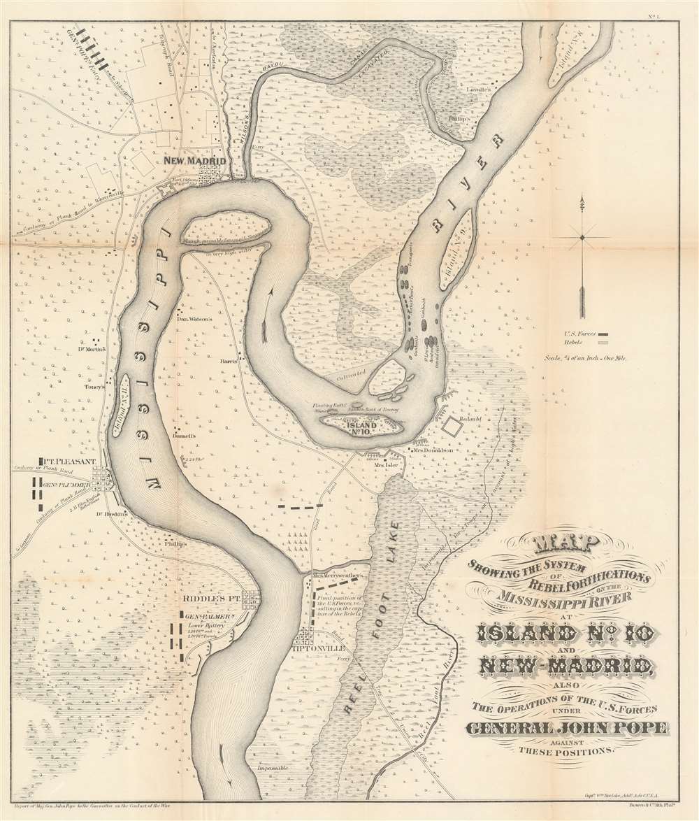
Map showing the system of rebel fortifications on the Mississippi River at Island No. 10 and New Madrid, also the operations of the U.S. forces under General John Pope against these positions.
1862 (undated) 18 x 21 in (45.72 x 53.34 cm) 1 : 84480
1862 (undated) 18 x 21 in (45.72 x 53.34 cm) 1 : 84480
Description
A scarce and important 1862 Civil War map illustrating the course of the Mississippi River in the vicinity of New Madrid, Point Pleasant, Riddles Point, and Tiptonville. This region, collectively known as the Kentucky Bend, is situated at the meeting point of Missouri, Kentucky, and Tennessee. The map was prepared by Major General John Pope, a Union Commander, to illustrate his decisive siege and take over the strategically situated and heavily fortified Island No. 10. Located just upriver from New Madrid, Island No. 10 is situated at a sharp northward curve in the Mississippi. The Confederate Army fortified the island realizing that, if they could control Island No. 10, they could effectively prevent Union forces from using the Mississippi as gateway to the Deep South.
About the General
General John Pope (March 16, 1822 - September 23, 1892) was the commander of Union Forces in the region. As former surveyor and member of the Army Corps of Engineers, Pope came up with an unusual solution. While distracting the Confederate Army with his troops positioned around Point Pleasant, he sent another part of his army northward to New Madrid, which the Confederacy had recently abandoned in favor of the more defensible position at Island No. 10. He had the New Madrid contingent of his forces excavate a wide canal through the Bayous east of New Madrid to reconnect with the Mississippi between Island Nos. 8 and 9. By passing transports and gunboats through the canal, Pope not only limited the strategic importance of Island No. 10, but also positioned troops on both the Missouri and Kentucky side of the river, thus surrounding the island and effectively cutting off its single supply line.Confederate Loss
The Confederate forces, outnumbered and surrounded, surrendered their position on Island No. 10 on April 8, 1862. The Union victory at Island No. 10 marked the first time the Confederate army lost a defensive position on the Mississippi River. It opened the Mississippi to navigation by the Union Navy nearly as far as Memphis and marked a major turning point in the Mississippi theater. When Admiral Farragut seized control of the Confederate city of New Orleans only three weeks later, the Confederacy found itself nearly cut in half by its most important artery - the Mississippi River.Publication History and Census
This map was laid down by William Hoelcke, a Union Officer and Chief engineer of the Department of the Missouri, on the instruction of the victorious Union commander, Major General John Pope. The map is derived from various sources, including Coast Survey preliminary studies, original survey work commanded by Pope, and earlier street plans of New Madrid, Point Pleasant, Riddles Point and Tiptonville. This map was published for the Report of Major General John Pope to the Committee on the Conduct of the War. It is considered a cardinal piece for collections focused on the early days of the American Civil War and the Mississippi River theater. The present example is identifiable as an exceptionally early edition by the use of the term 'Rebel' in the title, as subsequent editions substituted the term 'Confederate.' Later variants of this map appear in several subsequent publications, including the Civil War Atlas. We note five examples cataloged in OCLC: New York Historical Society Library, the Library of Congress, Pennsylvania State University, the David Rumsey Map Center at Stanford University, and the Birmingham Public Library in Birmingham, Alabama.CartographerS
Friedrich Handtke (December 7, 1815 - January 25, 1879) was a German engraver and cartographer active in the second half of the 19th century. Handtke was formally trained as a surveyor in the Prussian army. Following his discharge in 1838 he took a position as the head of cartography at the Głogów, Poland, publishing house of Carl Flemming. Initially, Handtke, in an attempt to hide his youth, inscribed his map publications as "Dr. Karl Sohr". From 1838 to 1874, Handtke and Flemming issued some 260 maps, about 168 of which Handke drew himself. Both Flemming and Handke died in 1879 leaving the powerful Flemming publishing house without its heads. Nonetheless, the firm continued to publish, and republish, well into the 20th century. Głogów, where Handtke was based, is currently part of modern day Poland's Lower Silesian Voivodeship. More by this mapmaker...
John Pope (March 16, 1822 - September 23, 1892) was an American military officer active in the middle part of the 19th century. Pope was born in Louisville Kentucky to a prominent family with close ties to future president Abraham Lincoln. He graded from West Point in 1842 and served in the Mexican American War before being appointed to the Army Bureau of Topographical Engineers. He served briefly under explorer John C. Fremont, but the two never really got along. During the American Civil War, Pope, now a Major General successfully led several campaigns in the Western Theater, including the strategic capture of the fortified Mississippi River Island No. 10, near New Madrid, Missouri. He was subsequently reassigned to the Eastern Front where he was less successful ultimately suffering a disastrous defeat in the Second Battle of Bull Run. Following the Civil War, Pope served briefly as Reconstruction Governor of the Third Military District (Georgia, Florida, and Alabama) and was eventually sent west for the Apache Wars. Despite having a brash argumentative manner, he argued for humane treatment of Native Americans and campaigned against the activities of the corrupt Indian Bureau. Pope retired in 1886 and died at the Ohio Soldiers Home in Sandusky, Ohio. Learn More...
John T. Bowen (b. c. 1801 - 1856) was a lithographer active in Philadelphia during the mid-19th century. Born in England, Bowen immigrated to the United States in 1834 and worked as a colorist and lithographer in New York City before moving to Philadelphia in 1838, most like with his collaborator and lithographic artist Alfred Hoffy. Once in Philadelphia, Bowen took over the business of Wild and Chevalier, located at 94 Walnut Street, and began publishing History of the Indian Tribes by McKenney and Hall. He also acquired the rights to Wild and Chevalier's series of views of Philadelphia, which he reissued at the end of 1838 and again in a hand colored edition in 1848. By the early 1840s, Bowen's work was garnering praise, and gained a reputation as one of the best lithographers in Philadelphia. He published the 'Architect's Digest' in 1839 and printed plates for Audubon's Quadrupeds (1845 - 1848) and the octavo edition of Birds of America (1839 - 1844). Despite numerous successes, Bowen field for bankruptcy in 1842, though it did not prove to be too much of a hindrance to his career, as, after 1844, he began working predominantly with Audubon and his sons on their works. Over the course of his career, Bowen became the preeminent Philadelphia lithographer and the most important mid-19th century American publisher of publication plates. By Bowen's death in 1856, he had a fairly substantial estate and a prosperous business. His wife, Lavinia, with whom he had a son, took over the business after her husband's passing and the firm Bowen and Company operated until around 1870. Learn More...
Source
Pope, J., Report of Maj. Gen. John Pope to the Committee on the Conduct of the War, (Washington D. C.: War Department) 1862.
Condition
Very good. Wear and toning along original fold lines. Closed tears extending 1.25 inches and 1.5 inches into printed area from left margin professionally repaired on verso. Verso repairs to fold separations. Blank on verso.
References
Rumsey 1780.010 (1895 edition with additional panels). Library of Congress Catalog no. 99447443. Stephenson, R. W., Civil War Maps: An Annotated List of maps and Atlases in the Library of Congress, 299.8. OCLC 47909293.