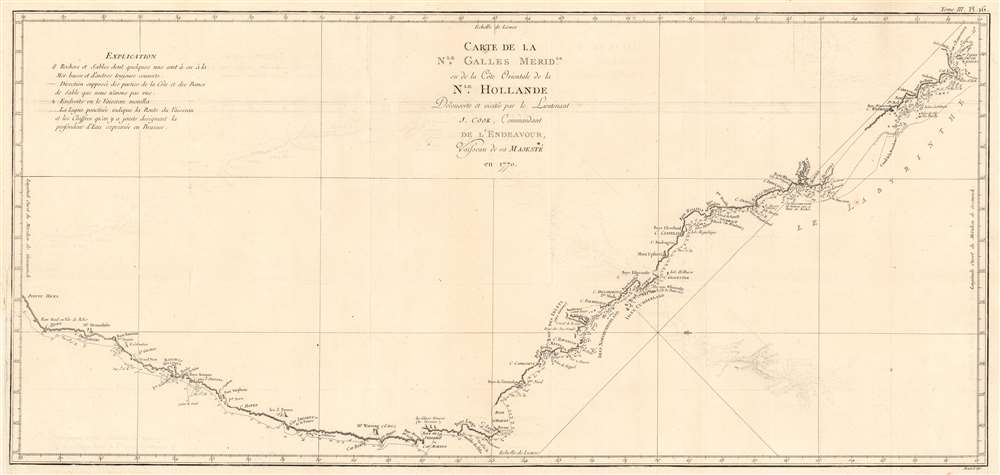
1774 Cook Map of New South Wales, Australia
NewSouthWales-cook-1774-2$1,200.00


Title
Carte de La Nle. Galles Meridle. Ou de la Cote Orientale de la Nle. Hollande Decouverte et visitee par le Lieutenant J. Cook, Commandant de L'Endeavour, vaisseau de sa Majeste en 1770.
1774 (undated) 14 x 30.5 in (35.56 x 77.47 cm) 1 : 4500000
1774 (undated) 14 x 30.5 in (35.56 x 77.47 cm) 1 : 4500000
Description
This is the 1774 first French edition of James Cook's seminal first map of New South Wales, Australia. The map is a product of Cook's search for the often speculated upon southern continent or 'Terra Australis,' which scholars from the 16th century on believed, based upon ancient Greek texts, must exist at the base of the world. This map is significant for Australia collectors as the first definitive mapping of the coasts of New South Wales.
A Closer Look
Oriented to the West, the map extends from Cape York, Prince of Wales Island, and the Endeavour Straits to Point Hicks (Victoria). The map notes both Botany Bay and Port Jackson.Cook's Voyage
After observing the Transit of Venus on June 3, 1769, Cook sailed westward, planning to return to England via the Cape of Good Hope, as he believed the Endeavour would not survive a second trip around Cape Horn. Instead, he sailed west, where he hoped to discover Terra Australis. He sailed around New Zealand and headed for Tasmania, intending to follow up on Abel Tasman's work, when gales forced him northward. On April 19, 1770, his second, Zachary Hicks, sighted land, what Cook immediately named Point Hicks. While Cook was most certainly aware he had not discovered 'Terra Australis,' he did spend several months, from April 19 to August 22, 1770, mapping the long sought east coast of New Holland (Australia), what he came to call New South Wales. He proceeded northwards, navigating the coast with great care, naming notable locations along the way.Unmapped Coast
It is of note that the coast between Cape Flattery and Weymouth remains unmapped. This area is so full of small islands and dangerous reefs that Cook aptly named it 'The Labyrinth.' Just as he entered this area, near Cape Tribulation, the Endeavour struck a reef. On our map, there is a note reading, 'On this ledge the ship laid 23 hours.' Rather than risk his ship further Cook sailed the Endeavour further out to sea, around the perilous reefs, landing at Cape York to officially name New South Wales and claim the land for England,I now once more hoisted English Coulers and in the Name of His Majesty King George the Third took possession of the whole Eastern Coast from the above Latitude [38] down to this place by the name of New South Wales, together with all the Bays, Harbors, Rivers, and Island s situate upon the said coast. (Cook, J., Journal, August 22, 1770)Until this time, it was assumed that Australia, or New Holland as it was known, was a barren wasteland, as the Dutch navigators had explored only a small part of the arid western coast. On the other hand, Cook sailed up the fertile east coast and was impressed by what he saw. It was Cook who recommended settlement and persuaded Joseph Banks to argue for using the remote continent as a penal colony. Cook's nomenclature largely remains in use today.
Publication History and Census
This map was engraved by Robert Bénard for the 1774 French edition of James Hawkesworth's 1773 account of Cook's voyages. It follows the 1772-1773 English edition engraved by William Whitchurch and published in 1773. There are known editions in English, French, and German. While well represented institutionally, this map is rare to the market.CartographerS
Captain James Cook (7 November 1728 - 14 February 1779) is a seminal figure in the history of cartography for which we can offer only a cursory treatment here. Cook began sailing as a teenager in the British Merchant Navy before joining the Royal Navy in 1755. He was posted in America for a time where he worked Samuel Holland, William Bligh, and others in the mapping of the St. Lawrence River and Newfoundland. In 1766 Cook was commissioned to explore the Pacific and given a Captaincy with command of the Endeavour. What followed were three historic voyages of discovery, the highlights of which include the first European contact with eastern Australia, the discovery of the Hawaiian Islands (among many other Polynesian groups), the first circumnavigation of New Zealand, some of the first sightings of Antarctica, the first accurate mapping of the Pacific Northwest, and ultimately his own untimely death at the hands of angry Hawaiians in 1779. The influence of Cook work on the mapping and exploration of the Pacific cannot be understated. More by this mapmaker...
John Hawkesworth (c. 1715 - November 16, 1773) was an English born writer and editor born London. Hawkesworth, who is said to have been self educated, succeeded Samuel Johnson as the parliamentary debate compiler for "Gentleman's Magazine". He was a deeply religious and moral map who brilliant defense of morality earned him an LL. D degree from the Archbishop of Canterbury. Hawkesworth went on to publish a series of scholarly books and essays including a 12 volume edition of Jonathan Swift's work. In 1772 Hawkesworth was commissioned by the Admiralty to compile and edit James Cook's journals. The resultant work An Account of the Voyages undertaken ... for making discoveries in the Southern Hemisphere was one of the first ethnographic account of the South Seas and was widely published in England and abroad. Though highly influential, Hawkesworth's work received heavy criticism from scholars who claim that he liberally altered much of the text in the name of morality. Learn More...
Robert Bénard (1734 - c. 1785) was a French engraver. Born in Paris, Bénard is best known for supplying a significant number of plates (at least 1,800) for the Encyclopédie published by Diderot and Alembert. He also is remembered for his work with the Académie des Sciences, most notably the Descriptions des Arts et Métiers Learn More...
Source
Hawkesworth, J., Relation des voyages entrepris par ordre de Sa Majeste britannique, actuellement regnante; pour faire des decouvertes dans l'hemisphere meridional ..., (Paris: Chez Saillant et Nyon ... Chez Panckoucke, Hotel de Thou) 1774.
Condition
Very good. Margin reinstated at insertion point not affecting image, else excellent.
References
OCLC 977416224. Australia in Maps, (National Library of Australia), page 51. National Library of Australia, MAP T 325. Tooley, R.V. (Australia) 325, pl.20. Tooley, R.V., Bricker, C.; Crone, Gerald Roe, Landmarks of Mapmaking; an Illustrated Survey of Maps and Mapmakers, p.263. Clancy, R. 6.33. Perry, T. M., and Prescott, D. F., A Guide to Maps of Australia in Books Published 1780-1830, 1773.02.