This item has been sold, but you can get on the Waitlist to be notified if another example becomes available, or purchase a digital scan.
1806 Blunt Map or Nautical Chart or New York City, New York
NewYork-blunt-1806$100.00

Title
New York.
1806 (dated) 8 x 4.5 in (20.32 x 11.43 cm) 1 : 200000
1806 (dated) 8 x 4.5 in (20.32 x 11.43 cm) 1 : 200000
Description
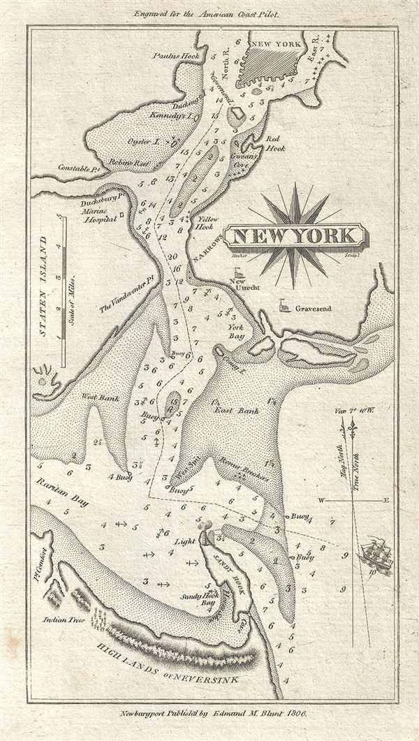
This is a scarce 1806 nautical chart or maritime map of New York City by Edmund Blunt. It covers the region including parts of lower Manhattan, Staten Island, Brooklyn and New Jersey. The map identifies several points, islands, bays including Sandy Hook, Red Hook, Yellow Hook, Point Comfort, etc. The towns of Gravesend and Utrecht are identified along with the Marine Hospital on Staten Island and a beautifully rendered lighthouse on Sandy Hook. Various banks and reefs are noted, along with some depth soundings, buoys and relief shown by hachure. This map was published by Edmund M. Blunt for issue in the 1806 edition of the American Coast Pilot.
Cartographer
Edmund March Blunt (June 20, 1770 - 1862) was an American navigator, bookseller, chartmaker, and cartographer based in Newburyport, Massachusetts. Blunt was born in Portsmouth, New Hampshire in 1770. In 1796, along with the nominal assistance of prominent navigator Captain Lawrence Furlong, Blunt published The American Coast Pilot, one of the most important published works on American navigation. Although much of the work was plagiarized from British publications, the Coast Pilot was an immediate popular success. In response to the popularity of his work, Blunt published 21 subsequent editions, each with important updates and revisions. The first edition to contain map plates was printed in 1804. Following a fire that destroyed his offices at The Sign of the Bible in 1811, Blunt moved his business to New York and opened a new shop, The Sign of the Quadrant. His sons Edmund Jr. (1799 - 1866) and George William (1802 - 1878), joined the firm in 1824 and eventually took over the family business, renaming the firm 'E. and G. W. Blunt'. They both produced their own nautical books, charts, and instruments, as well as republished their father’s work. In 1830, Edmund accepted a position under Ferdinand Hassler at the United States Office of the Coast Survey. Much of Blunt's original work eventually found its way into U.S. Coast Survey Publications. George closed the firm in 1872 and sold the plates and chart copyrights to the U.S. Coast Survey and the U.S. Navy Hydrographic Office. Due to the quality and detail of Blunt's work, revised editions of his most important charts were republished well into the 1880s. More by this mapmaker...
Source
Blunt, E.,American Coast Pilot, 1806.
Condition
Very good. Original plate mark visible. Minor spotting.