
This item below is out of stock, but another example (left) is available. To view the available item, click "Details."
Details
1846 Bradford Map of New York
1846 (dated) $250.00
1846 Bradford City Map or Plan of New York City and Brooklyn
NewYork-bradford-1846$250.00

Title
New York.
1846 (dated) 15 x 12 in (38.1 x 30.48 cm) 1 : 24000
1846 (dated) 15 x 12 in (38.1 x 30.48 cm) 1 : 24000
Description
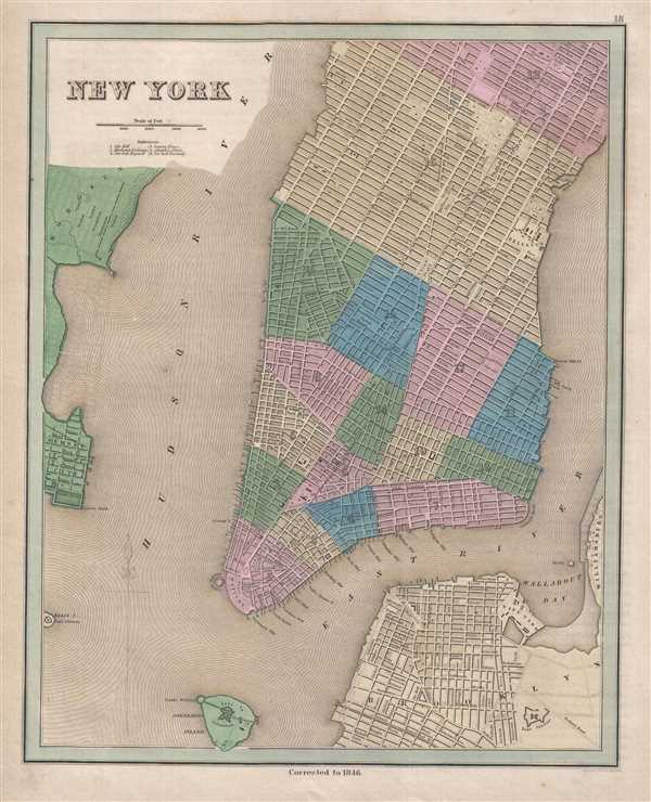
This is an 1846 Thomas Bradford city map or plan of New York City. The map depicts the region from Hoboken, New Jersey to the East River and Williamsburg and from Fifty-Third Street to Brooklyn and Governor's Island. At this point in New York City's history, New York, Brooklyn, and Williamsburg were each a separate entity. Williamsburg had been a part of the Town of Bushwick until it separated from Bushwick in 1840 and would remain independent until both Williamsburg and Bushwick were annexed by the City of Brooklyn in 1855 as the 'Eastern District'. Brooklyn would become part of the City of Greater New York in 1898, along with Staten Island, the Bronx, and Queens.
New York (Manhattan) is divided into sixteen wards with all of the major streets and avenues labeled from the Battery to Fifty-Third and from the Hudson River to the East River. Six locations on Manhattan are identified numerically, including City Hall, the Merchants Exchange, Columbia College (which would become Columbia University) and New York University. Each of the major squares and places is labeled, such as Washington Square, Madison Square, and Union Place, along with the Deaf and Dumb Asylum between Forty-Eighth and Fiftieth Streets on Fourth Avenue. The Harlem Railroad is illustrated in its original route along Fourth Avenue and then the Bowery to City Hall Park. Nearly one dozen slips are labeled along the East River. In Brooklyn, the city's streets are illustrated and labeled, along with the Navy Yard, the Long Island Railroad, and Fort Greene. First Street is the only street labeled in Williamsburg, although a handful of others are illustrated. Fort Columbus and Castle William are illustrated on Governor's Island, along with Fort Gibson on Ellis Island.
This map was engraved by George Boynton and published by Thomas Bradford in 1846.
CartographerS
Thomas Gamaliel Bradford (1802 - 1887) was born in Boston, Massachusetts, where he worked as an assistant editor for the Encyclopedia Americana. Bradford's first major cartographic work was his revision and subsequent republishing of an important French geography by Adrian Balbi, Abrege de Geographie published in America as Atlas Designed to Illustrate the Abridgment of Universal Geography, Modern and Ancient. Afterwards Bradford revised and expanded this work into his own important contributions to American cartography, the 1838 An Illustrated Atlas Geographical, Statistical and Historical of the United States and Adjacent Countries. Bradford's cartographic work is significant as among the first to record Texas as an independent nation. In his long career as a map publisher Bradford worked with William Davis Ticknor of Boston, Freeman Hunt of New York, Charles De Silver of Philadelphia, John Hinton, George Washington Boynton, and others. We have been able to discover little of Bradford's personal life. More by this mapmaker...
George Washington Boynton (fl. c. 1830 - 1850) was a Boston based cartographer and map engraver active in the first half of the 19th century. Boynton engraved and compiled maps for numerous publishers including Thomas Bradford, Nathaniel Dearborn, Daniel Adams, and S. G. Goodrich. His most significant work is most likely his engraving of various maps for Bradford's Illustrated Atlas, Geographical, Statistical, and Historical, of the United States and the Adjacent Countries and Universal Illustrated Atlas. He also engraved for the Boston Almanac. In 1835, Boynton is listed as an employee of the Boston Bewick Company, an engraving, stereotype, and printing concern based at no. 47 Court Street, Boston. Little else is known of his life. Learn More...
Source
Bradford, T. G. and Goodrich, S. G., A Universal Illustrated Atlas, exhibiting a Geographical, Statistical, and Historical view of the World, (Boston: Charles D. Strong) 1846.
The Universal Illustrated Atlas is one of the great American atlases of the first half of the 19th century. The atlas was first published in 1838 under the imprint of Charles D. Strong. It replaced and superseded Bradford's earlier smaller format Illustrated Atlas, Geographical, Statistical, and Historical, of the United States and the Adjacent Countries. Numerous reissues of the Universal Illustrated Atlas followed until about 1848. Although there are minor variations between the editions, most contain about 50 maps, the majority of which focus on the United States. Bradford's atlases are significant for recording North America during the Republic of Texas Era. In later editions, particularly the 1846 edition, Bradford illustrates the boom in railroad construction, possibly with the idea that his maps would aid travelers in planning journeys by rail. It was compiled by Thomas Gamaliel Bradford and Samuel Griswold Goodrich with most of the plates engraved by George Washington Boynton (fl. c. 1830 - 1850). Other contributors include Thomas Gordon (1778 - 1848), Fielding Lucas Jr. (1781 - 1854), Samuel Edward Stiles (1844 - 1901), Sherman and Smith (fl. c. 1829 - 1855), and Horace Thayer (1811 - c. 1874).
Condition
Very good. Even overall toning. Closed margin tear professionally repaired on verso. Blank on verso.
References
Rumsey 0089.001 (1838 edition).